Report on Monowai (New Zealand) — November 1997
Bulletin of the Global Volcanism Network, vol. 22, no. 11 (November 1997)
Managing Editor: Richard Wunderman.
Monowai (New Zealand) Inferred eruption during 15-18 December
Please cite this report as:
Global Volcanism Program, 1997. Report on Monowai (New Zealand) (Wunderman, R., ed.). Bulletin of the Global Volcanism Network, 22:11. Smithsonian Institution. https://doi.org/10.5479/si.GVP.BGVN199711-242050
Monowai
New Zealand
25.887°S, 177.188°W; summit elev. -132 m
All times are local (unless otherwise noted)
A cluster of high-amplitude acoustic signals from Monowai was recorded during 15-17 December (figure 4). During the activity, 171 acoustic waves of varying duration were recorded. Of the waves, nine were interpreted as explosive, determined according to seismic signal characteristics. The explosive waves occurred during the first episode of heightened activity on 15 December. The signals indicated that an eruptive event stronger than those of September 1996 (BGVN 21:11) and April 1997 (BGVN 22:05) was occurring. However, infrared and visible GOES-9 imagery showed no evidence of near-surface activity.
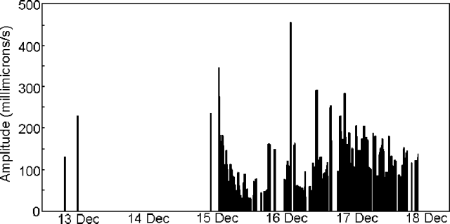 |
Figure 4. Acoustic signals from Monowai Seamount during 13-18 December. Courtesy of O. Hyvernaud. |
Three small acoustic waves on 12 and 14 December preceded the heightened activity. The first high- amplitude acoustic wave was generated at 2330 GMT on 14 December; the last was generated at 2021 GMT on 17 December. The acoustic activity stopped suddenly after a sequence of weak, very long acoustic waves. The strongest wave, generated at 0021 GMT on 16 December, had a peak-to-peak amplitude of 0.46 mm/s but was not explosive.
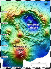
Monowai Seamount lies midway between the Kermadec and Tonga Islands, ~1,400 km NE of New Zealand. The adjacent trench is significantly shallower (~4 km) than the Tonga and Kermadec trenches (9-11 km deep). A T-wave swarm was detected in November 1995 (BGVN 20:11/12). Other noteworthy recent activity at Monowai included a possible eruption in 1944, and about seven documented eruptions during 1977-90 (BGVN 16:03).
Geological Summary. Monowai, also known as Orion seamount, is a basaltic stratovolcano that rises from a depth of about 1,500 to within 100 m of the ocean surface about halfway between the Kermadec and Tonga island groups, at the southern end of the Tonga Ridge. Small cones occur on the N and W flanks, and an 8.5 x 11 km submarine caldera with a depth of more than 1,500 m lies to the NNE. Numerous eruptions have been identified using submarine acoustic signals since it was first recognized as a volcano in 1977. A shoal that had been reported in 1944 may have been a pumice raft or water disturbance due to degassing. Surface observations have included water discoloration, vigorous gas bubbling, and areas of upwelling water, sometimes accompanied by rumbling noises. It was named for one of the New Zealand Navy bathymetric survey ships that documented its morphology.
Information Contacts: Olivier Hyvernaud, BP 640, Laboratoire de Geophysique, Papeete, Tahiti, French Polynesia.