Report on Popocatepetl (Mexico) — December 1997

Bulletin of the Global Volcanism Network, vol. 22, no. 12 (December 1997)
Managing Editor: Richard Wunderman.
Popocatepetl (Mexico) Explosion on 1 January causes fires, ashfall
Please cite this report as:
Global Volcanism Program, 1997. Report on Popocatepetl (Mexico) (Wunderman, R., ed.). Bulletin of the Global Volcanism Network, 22:12. Smithsonian Institution. https://doi.org/10.5479/si.GVP.BGVN199712-341090
Popocatepetl
Mexico
19.023°N, 98.622°W; summit elev. 5393 m
All times are local (unless otherwise noted)
Following the 24 December 1997 eruption (BGVN 22:11) Popocatépetl had several days of low activity followed by two moderate type-A seismic events and an explosion on 1 January. The earthquakes occurred 5.8 and 7.5 km SE of the crater at depths of 4.4 and 4.7 km, respectively. An eruption at 1827 on 1 January (figure 23) sent a large ash column 5 km above the summit and caused ashfall on towns to the SE such as San Baltasar Atlimeyaya, Metepec, and Atlixco. Incandescent material was ejected NW from the crater and started grass fires (figure 23). The event lasted for 1.5 minutes; after 20 minutes, activity returned to normal. Later observations revealed that no substantial changes had taken place but that a flow-detection station on the Espinera ravine had been destroyed by rockfall.
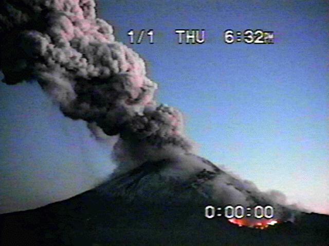 |
Figure 23. Image of the N flank of Popocatépetl taken at 1832 on 1 January 1998. The bright area in the right-hand corner corresponds to grass fires. Courtesy of CENAPRED. |
During 2-20 January, normal conditions prevailed; continuous gas-and-steam emissions, small ash exhalations, and occasional low- to moderate-intensity Type-A events were observed. On 6 January, a moderate exhalation at 0049 produced a glow and was followed by a sequence of moderate tectonic events leading to 8 minutes of small tremor. The seismic activity was probably associated with movement of the lava dome. A 3-minute tremor was recorded at 0105 on 16 January and on the next day a 2-minute sequence of volcanic events occurred. During 18-20 January, seismicity and the number of exhalations increased slightly.
Geological Summary. Volcán Popocatépetl, whose name is the Aztec word for smoking mountain, rises 70 km SE of Mexico City to form North America's 2nd-highest volcano. The glacier-clad stratovolcano contains a steep-walled, 400 x 600 m wide crater. The generally symmetrical volcano is modified by the sharp-peaked Ventorrillo on the NW, a remnant of an earlier volcano. At least three previous major cones were destroyed by gravitational failure during the Pleistocene, producing massive debris-avalanche deposits covering broad areas to the south. The modern volcano was constructed south of the late-Pleistocene to Holocene El Fraile cone. Three major Plinian eruptions, the most recent of which took place about 800 CE, have occurred since the mid-Holocene, accompanied by pyroclastic flows and voluminous lahars that swept basins below the volcano. Frequent historical eruptions, first recorded in Aztec codices, have occurred since Pre-Columbian time.
Information Contacts: Roberto Meli, Roberto Quaas Weppen, Alejandro Mirano, Bertha López Najera, Alicia Martinez Bringas, A. Montalvo, G. Fregoso, and F. Galicia, Centro Nacional de Prevencion de Desastres (CENAPRED); J.L. Macias, Instituto de Geofisica, UNAM, Circuito Cientifico C.U. 04510 México D.F., México.