Report on Nevado del Huila (Colombia) — February 1998

Bulletin of the Global Volcanism Network, vol. 23, no. 2 (February 1998)
Managing Editor: Richard Wunderman.
Nevado del Huila (Colombia) Significant increase in seismicity in December 1997
Please cite this report as:
Global Volcanism Program, 1998. Report on Nevado del Huila (Colombia) (Wunderman, R., ed.). Bulletin of the Global Volcanism Network, 23:2. Smithsonian Institution. https://doi.org/10.5479/si.GVP.BGVN199802-351050
Nevado del Huila
Colombia
2.93°N, 76.03°W; summit elev. 5364 m
All times are local (unless otherwise noted)
The Observatorio Vulcanológico y Sismológico de Popayán (OVSP) reported increased seismicity at the Nevado del Huila volcanic complex. The complex is studied using three seismic stations in SW Colombia. One substantial seismic increase occurred during 20-25 December 1997. About 108 volcano-tectonic earthquakes in three swarms were located in a small area 3 km east of Pico Norte (figure 2). Seismic activity has not previously been known in this area. The swarms were 6-8.5 km in depth (figure 3) with magnitudes ranging from 0.93 to 2.98 (Richter scale).
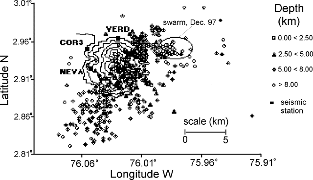 |
Figure 2. Epicenter map showing volcano-tectonic seismicity at the Nevado del Huila complex during January to December 1997. Courtesy OVSP. |
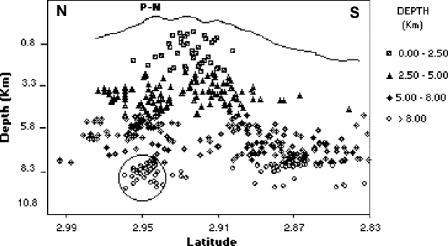 |
Figure 3. Depths of volcano-tectonic seismicity at Nevado del Huila during January to December 1997. Courtesy OVSP |
A second increase, energy released by volcano-tectonic earthquakes, has grown over the last two years. The period with the largest recorded energy was associated with the swarms of late December 1997, which totaled 1.20 x 10⁸ ergs (figure 4).
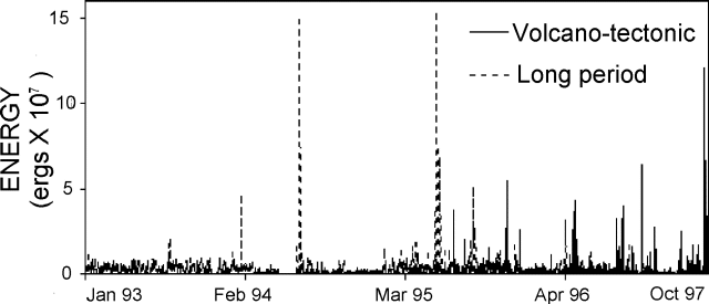 |
Figure 4. Seismic energy from volcano-tectonic and long-period (LP) earthquakes recorded at stations monitoring Nevado del Huila, 1993-1998. Courtesy OVSP. |
The Nevado del Huila volcanic complex is comprised of three main peaks aligned N-S; these are named Pico Norte, Pico Central and Pico Sur. Pico Central is the highest summit in the Cordillera Central, is composed of interbedded tephra and steep-sided lava flows located inside an old caldera. The sole known eruption recorded in historical time was an explosion in the 16th century. Two persistent steam columns rise from the southern peak and hot springs surround the volcano. The volcano has 13.4 km2 of glacial cover.
Geological Summary. Nevado del Huila, the highest peak in the Colombian Andes, is an elongated N-S-trending volcanic chain mantled by a glacier icecap. The andesitic-dacitic volcano was constructed within a 10-km-wide caldera. Volcanism at Nevado del Huila has produced six volcanic cones whose ages in general migrated from south to north. The high point of the complex is Pico Central. Two glacier-free lava domes lie at the southern end of the volcanic complex. The first historical activity was an explosive eruption in the mid-16th century. Long-term, persistent steam columns had risen from Pico Central prior to the next eruption in 2007, when explosive activity was accompanied by damaging mudflows.
Information Contacts: Fabiola Patricia Rodríguez and Juan Carlos Diago, Observatorio Vulcanológico y Sismológico de Popayán, Calle 5B 2-14, Popayán, Colombia.