Report on Peuet Sague (Indonesia) — April 1998
Bulletin of the Global Volcanism Network, vol. 23, no. 4 (April 1998)
Managing Editor: Richard Wunderman.
Peuet Sague (Indonesia) Pilots spot ash erupting from remote volcano in N Sumatra beginning in late April
Please cite this report as:
Global Volcanism Program, 1998. Report on Peuet Sague (Indonesia) (Wunderman, R., ed.). Bulletin of the Global Volcanism Network, 23:4. Smithsonian Institution. https://doi.org/10.5479/si.GVP.BGVN199804-261030
Peuet Sague
Indonesia
4.903°N, 96.289°E; summit elev. 2785 m
All times are local (unless otherwise noted)
An eruption of Mount Peuet Sague, in a remote part of northern Sumatra, was first seen the morning of 26 April by pilots. Indonesia's Antara news agency reported on 27 April that a pilot of the national airline, Garuda, saw a volcano erupting in the province of Aceh, in the Pidie area. The report said the pilot saw ash to an altitude of ~3 km as he flew over at ~7 km altitude. The report also quoted the local Air Force chief as saying a fighter pilot spotted fire and thick smoke issuing from the mountain. It was the second recent eruption there: the first, on 19 April, was obscured by thick smoke from forest fires.
Officials at the Ministry of Mines and Energy, which has responsibility for monitoring volcanic activity in Aceh Province, reported a phreatic eruption. The active crater is near Mount Tutung, 2 km W of the peak of Peuet Sague. The nearest village sits 8 km W of the eruption center. No one was harmed and it appears few noticed, as there were no accounts from local residents of sounds, tremors, or ashfall. There were some indications of material ejected from the crater. A 15 May statement said white smoke was weakly issuing from the volcano, but that all other activity had ceased.
Peuet Sague is remote and scientific information is accordingly difficult to collect. VSI observers who went to the area shortly after the latest eruption were delayed because they had to walk nearly four days to reach the volcano. The Mount Peuet Sague Volcano Observatory was initiated at the end of 1997 but had been equipped with neither monitoring devices nor observers at the time of this activity. VSI planned to install one radio telemetric seismograph and to employ one observer by late May 1998.
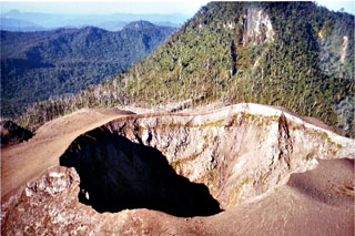
Background. The name Peuet Sague, which has numerous spelling variants (e.g. Peut Sagoe, Peuet Sagu, Puet Sagu, Peuet Sagoee), means "square." Accordingly, Peuet Sague, a stratovolcano, contains four summit peaks. It is located in Sigli Regency, Aceh Province near Seulawah Agam and Burni Telong volcanoes. The crater believed to be active resides SE of one of the peaks of the lava dome (Mount Tutung). This narrow crater has a diameter of about 70 m and a depth of 80 m.
According to Igan Sutawidjaja, a May 1920 expedition was stopped by heavy ashfall and a 1952 expedition spent 20 days without reaching the volcano. A 1975 team reached the peak after nine days but found no eruptive activity. They documented a lake (500 x 800 m) at the foot of Mount Tutung containing water at a temperature of 19°C. Within Tutung's crater they found a small (40 x 75 m) blue lake with a temperature of 21°C. This intracrater lake was surrounded by four solfataras (with temperatures of 59-78°C).
The last major eruption occurred in 1918-21 when ash was emitted, a lava dome was formed, and pyroclastic flows spilled into surrounding uninhabited forests. Scientists inspecting the summit area in 1984 found burned trees surrounding the main crater, likely due to a 1979 eruption. Local eye-witnesses and pilots reported ash columns above the summit in 1979, 1986, and 1991. An expedition in 1984 found burned trees surrounding the crater, attributed to the 1979 eruption. Uncertain activity was reported in 1949.
Geological Summary. Peuet Sague is a large volcanic complex in NW Sumatra. The volcano, whose name means "square," contains four summit peaks, with the youngest lava dome being located to the N or NW. This extremely isolated volcano lies several days journey on foot from the nearest village and is infrequently visited. The first recorded historical eruption took place from 1918-21, when explosive activity and pyroclastic flows accompanied summit lava-dome growth. The active crater is located NE of the Gunung Tutung lava dome and has typically produced small-to-moderate explosive eruptions.
Information Contacts: Mahbub Iskandar, Ministry of Mines and Energy, Banda Aceh, Sumatra, Indonesia; Igan S. Sutawidjaja, Volcanological Survey of Indonesia (VSI), Jalan Diponegoro No.57, Bandung 40122, Indonesia (URL: http://www.vsi.esdm.go.id/); Reuters News Agency; Associated Press.