Report on Kilauea (United States) — April 1998

Bulletin of the Global Volcanism Network, vol. 23, no. 4 (April 1998)
Managing Editor: Richard Wunderman.
Kilauea (United States) Brief magma surge on 5 April, bench collapse 13-14 April
Please cite this report as:
Global Volcanism Program, 1998. Report on Kilauea (United States) (Wunderman, R., ed.). Bulletin of the Global Volcanism Network, 23:4. Smithsonian Institution. https://doi.org/10.5479/si.GVP.BGVN199804-332010
Kilauea
United States
19.421°N, 155.287°W; summit elev. 1222 m
All times are local (unless otherwise noted)
During April, Kīlauea's steady eruption continued. On most days lava issued quietly from an area near the S flank of Pu`u `O`o and traveled ~12 km in tubes to the coast. At the coast, the tube system discharged ~300,000-400,000 m3 of lava per day and built benches at Waha`ula and Kamokuna. In past months these sites have discharged roughly equal amounts of lava, but in April the Kamokuna site discharged a higher percentage of the lava. On 13-14 April a bench collapse removed 1.5 hectares of newly formed land at Kamokuna. Before the collapse the bench was 400 m long and 80 m wide at its greatest breadth.
On 4 April the magma supply to the tube system was obstructed, causing activity at the coastal entry sites to dissipate. Coincident with the blockage, the summit area inflated gradually (figure 120), gaining about 3 µrad of tilt. The inflation ended roughly coincident with a M 4.1 earthquake near the summit at 1243 on 5 April. Deflation at the summit sent a surge of magma into the tube system; lava issued from numerous weak points in tubes at the top of Pulama Pali. The surface flows lasted about 12 hours, and by the next day, the tube system had returned to normal activity. These short-lived pauses have occurred irregularly; since March 1997, 16 such pauses have occurred.
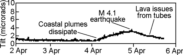 |
Figure 120. Tiltmeter record showing the N-S component at Kīlauea's Uwekahuna 7-m borehole site during 2-6 April 1998. Courtesy of HVO. |
Three small, recent pits on the crater floor periodically spilled small lava flows across the floor during 1-17 April. All these flows remained within Pu`u `O`o's crater. In mid-April, a new collapse pit ~50 m in diameter formed on the outer S flank of Pu`u `O`o. This and another pit 70 m to the SW were adjacent to a large December 1997 collapse pit (BGVN 22:11). These pits were formed when magma moving beneath Pu`u `O`o entrained blocks from its conduit into the tube system, causing the ground surface to collapse where the conduit was shallow.
During the last week of April, eruptive activity within Pu`u `O`o crater subsided; lava was not seen on the crater floor during 25 April-7 May and no night glow was visible. Residents of the Big Island felt 5 earthquakes, M 3.3-4.3, during 3-7 May. The largest earthquake occurred on 7 May and was located in the Pahala region of Ka`u (immediately W of Hawaii Volcanoes National Park) at 8.6 km depth.
During 10-11 May, University of Hawaii professor Steve Self observed a sequence of lava effusion and drainage that had developed within Pu`u `O`o cone. The E pit of the crater filled with lava from 1-2 vents over 10-20 minutes, followed by lava overspill back to the main Pu`u `O`o vent. Minor lava fountaining in both pits accompanied the pit-filling phases. After 10-20 minutes of vigorous mixing of the lava in the pits, a brief period of lava fountaining occurred followed by rapid drainage to the tube system. This activity was accompanied by 30-m-high fountains and vigorous gas release, although none of the fountaining lava fell outside the crater wall.
Kīlauea is one of five coalescing volcanoes that comprise the island of Hawaii. Historically its eruptions originated primarily from the summit caldera or along one of the lengthy E and SW rift zones that extend from the summit caldera to the sea. This latest Kīlauea eruption began in January 1983 along the E rift zone. The eruption's early phases, or episodes, occurred along a portion of the rift zone that extends from Napau Crater on the uprift end to ~8 km E on the downrift end. Activity eventually centered on what was later named Pu`u `O`o. More than 223 hectares of new land have been added to the island and local communities have suffered more than $100 million in damages since the beginning of the eruption.
Geological Summary. Kilauea overlaps the E flank of the massive Mauna Loa shield volcano in the island of Hawaii. Eruptions are prominent in Polynesian legends; written documentation since 1820 records frequent summit and flank lava flow eruptions interspersed with periods of long-term lava lake activity at Halemaumau crater in the summit caldera until 1924. The 3 x 5 km caldera was formed in several stages about 1,500 years ago and during the 18th century; eruptions have also originated from the lengthy East and Southwest rift zones, which extend to the ocean in both directions. About 90% of the surface of the basaltic shield volcano is formed of lava flows less than about 1,100 years old; 70% of the surface is younger than 600 years. The long-term eruption from the East rift zone between 1983 and 2018 produced lava flows covering more than 100 km2, destroyed hundreds of houses, and added new coastline.
Information Contacts: Hawaiian Volcano Observatory (HVO), U.S. Geological Survey, PO Box 51, Hawaii Volcanoes National Park, HI 96718, USA (URL: https://volcanoes.usgs.gov/observatories/hvo/); K. H. Rubin and Mike Garcia, Hawaii Center for Volcanology, University of Hawaii, Dept. of Geology & Geophysics, 2525 Correa Rd., Honolulu, HI 96822 USA (URL: http://www.soest.hawaii.edu/GG/hcv.html).