Report on Sabancaya (Peru) — May 1998

Bulletin of the Global Volcanism Network, vol. 23, no. 5 (May 1998)
Managing Editor: Richard Wunderman.
Sabancaya (Peru) Summit activity, ice observed on visit in May
Please cite this report as:
Global Volcanism Program, 1998. Report on Sabancaya (Peru) (Wunderman, R., ed.). Bulletin of the Global Volcanism Network, 23:5. Smithsonian Institution. https://doi.org/10.5479/si.GVP.BGVN199805-354006
Sabancaya
Peru
15.787°S, 71.857°W; summit elev. 5960 m
All times are local (unless otherwise noted)
Sabancaya was observed by scientists of the National Air and Space Museum's Colca Valley Geohazard Project during a four-day visit (18-21 May) made in preparation for field work later in the year. Continuous fumarolic activity at the E side of the crater rim was observed during this visit. Seasonal snow patches were visible on the SE flank that were not present when the team made an aerial observation in July 1997 (BGVN 22:07).
On 18 May a seismic event was noted by observers traveling in a vehicle on the Pampa Lliullipampa, SE of the volcano. The disturbance produced a dust cloud that spanned the entire Ampato-Sabancaya-Hualca Hualca complex along its E slopes, a distance of 15 kilometers. A video camera recorded the disturbance at 1525 on 18 May. Roughly concurrently, scientists at the Instituto Geofísico in Arequipa detected a deep focus M 6 earthquake centered 250 km to the N near Ayacucho. Tremors occurred at this time in the pueblo of Cabana Conde located 15 kilometers NW of Hualca Hualca.
On 20 May A. Seimon of the University of Colorado ascended Sabancaya's SE flank and recorded a video of the fumarolic activity inside the crater rim, including the steady emission of gas from the crater floor (figure 8). He noticed ice along the route up the E flank. The ice lies beneath a layer of ash 5 to 10 cm thick, a depth that seemed sufficient to insulate it from higher surface temperatures. Ice was also observed filling a breach in the N side of the crater rim.
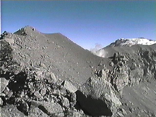 |
Figure 8. Video frame showing the inside of the S rim of Sabancaya's crater. The fumarole was continuous during the observation period (18-21 May). Snow-covered Nevado Ampato is visible beyond the crater rim. Courtesy of A. Seimon. |
Sabancaya is the youngest of the three adjacent stratovolcanoes located 75 km NW of Arequipa. The volcano's 29 May 1990 eruption produced a plume reaching a maximum height of 7 km (BGVN 15:05). The plume traveled NE and carried fine ash that fell up to 20 km away. Extensive mudflows (not mudslides) had occurred in the area in the months after the Sabancaya eruptions that began in late May 1990. These mudflows resulted from fallen ash and the subsequent melting of snow and ice on Hualca Hualca (BGVN 16:05; v. 15, no. 5).
Geological Summary. Sabancaya, located in the saddle NE of Ampato and SE of Hualca Hualca volcanoes, is the youngest of these volcanic centers and the only one to have erupted in historical time. The oldest of the three, Nevado Hualca Hualca, is of probable late-Pliocene to early Pleistocene age. The name Sabancaya (meaning "tongue of fire" in the Quechua language) first appeared in records in 1595 CE, suggesting activity prior to that date. Holocene activity has consisted of Plinian eruptions followed by emission of voluminous andesitic and dacitic lava flows, which form an extensive apron around the volcano on all sides but the south. Records of observed eruptions date back to 1750 CE.
Information Contacts: F. Engle, Center for Earth and Planetary Studies (CEPS), National Air and Space Museum, Smithsonian Institution, Washington, D.C. 20560 USA; A. Seimon, Department of Geography, University of Colorado, Boulder, CO 80309-0260 USA; S.O. Brooks, Department of Geography, University of Wisconsin, Madison, WI USA 53706-1491.