Report on Guagua Pichincha (Ecuador) — August 1998

Bulletin of the Global Volcanism Network, vol. 23, no. 8 (August 1998)
Managing Editor: Richard Wunderman.
Guagua Pichincha (Ecuador) Phreatic discharges reappear after robust off-flank seismicity
Please cite this report as:
Global Volcanism Program, 1998. Report on Guagua Pichincha (Ecuador) (Wunderman, R., ed.). Bulletin of the Global Volcanism Network, 23:8. Smithsonian Institution. https://doi.org/10.5479/si.GVP.BGVN199808-352020
Guagua Pichincha
Ecuador
0.171°S, 78.598°W; summit elev. 4784 m
All times are local (unless otherwise noted)
A seismic swarm occurred off Guagua Pichincha's NE flank during May-September 1998. On 4 August during the course of this swarm a M 7.1 earthquake struck near the coast; days later the stratovolcano began a series of modest phreatic eruptions. The eruptions continued through at least early October when they prompted local front-page news stories. As this report went to press in early October, the hazard status was Yellow, the second stage in an alert scheme of White, Yellow, Orange, and Red.
During the seismic swarm, earthquakes were centered in a zone ~15 km NE from Pichincha's summit. The epicentral zone lies on the S fringes of Casitagua, a volcano with no known eruptions in at least the last ~100,000 years.
The May-September swarm had not ended when this report was compiled in early September, and in total produced ~2,500 earthquakes through that time. During successive months of the swarm's progression, earthquakes became more numerous. Scientists located about 10 of the swarm's events of local magnitude 4.0-4.2, and they found that the hypocenters progressed towards the surface, from ~14 km depth during June to ~8 km depth during September. When these hypocenters were plotted on a vertical section oriented SW-NE, no lateral offset was visible, implying that the foci of these larger, located earthquakes rose vertically over time.
An active compressional fault along the Quito's E margin (the Quito fault) dips W beneath the city and underlies both volcanoes at depth. As noted above, the located earthquakes did not appear to follow the W-dipping fault, and epicenters trended oblique to the fault's N-S surface trace as they defined a zone aligned NW-SE. Still, the swarm was interpreted as tectonic, associated with the Quito fault.
The M 7.1 earthquake on 4 August struck ~175 km to Pichincha's SW on Ecuador's coast, a few tens of kilometers NE and inland from the port of Bahìa de Caràquez (0.59°S, 80.39°W). The U.S. Geological Survey made a preliminary assessment of the 4 August earthquake as Ms 7.1. The earthquake occurred at 1359 (1859 GMT); the preliminary depth was given as 33 km.
Phreatic eruptions began at 0156 on 7 August; 10-15 others followed into early September. Seismic signals indicated that in some cases eruptive degassing persisted up to 25 hours, type-A earthquakes occurred, but tremor was rare. The eruptions discharged gas, mud, and lithics, but no juvenile tephra. A veneer of these deposits appeared over the N crater floor when photographed on 15 September (figures 7 and 8). At that time, the crater's post-1660 dome gently steamed. The dome's N surface lay beneath a veneer of material deposited during and after phreatic eruptions on 7 August. The veneer contained mud and lithics but no juvenile tephra; some of this material formed small lahars that traversed around the dome and spilled out of the crater (figures 7 and 8). A visit to a crater overlook on 15 September disclosed that just beyond the rim of the explosion crater's N side, some new fractures arc around its circumference (arrow, figure 8).
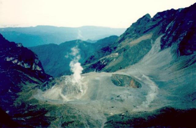 |
Figure 7. Photograph of the Guagua Pichincha crater taken at 0930 on 15 September 1998 looking out the breached W-crater wall (N is to the right). The photo was shot from a terrace inside the 2-km-diameter crater at a point ~ 1.2 km from the dome. The dome, which grew after the 1660 eruption, contains a prominent phreatic explosion crater on its NE slope. This explosion crater formed in 1981 and has since enlarged towards the dome's summit so that at the time of the photo it had a maximum diameter of ~ 150 m. Due to recent phreatic eruptions from this explosion crater, a thin veneer of non-juvenile ash coated the N dome and crater. Some of this ash later eroded and formed a narrow lahar circling around the dome's E margin and escaping the crater's confines at the W-opening breach. Courtesy of Patty Mothes, Escuela Politécnica Nacional. |
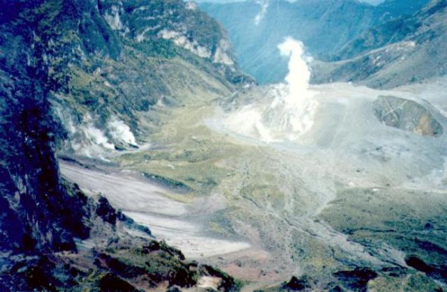 |
Figure 8. Photograph of the Guagua Pichincha crater taken around 0930 on 15 September 1998 looking out the breached W-crater wall (N is to the right); the photo was shot ~1.2 km from the dome. The label indicates the center of the narrow lahar circling clockwise around the dome's E margin and leaving the crater through the W-opening breach. The white arrow at the right side of the figure indicates the location of new fractures arcing around the explosion crater's N side. Courtesy of Patty Mothes, Escuela Politécnica Nacional. |
This phreatic episode lacked non-seismic precursors. EDM on the crater walls, on the SE flank, and on the dome showed relatively little change. SO2 flux, measured with COSPEC, lacked a spike. The crater, however, was judged too dangerous to enter for the purpose of obtaining in-situ gas samples. In 1997, the maximum temperature of gases escaping the dome was ~120°C.
During the first week of September seismicity consisted largely of A-type events, although some long-period events registered and meager tremor was seen. Degassing was too small to produce a conspicuous plume. On 6 September Quito residents felt two earthquakes; they were M 3.5 and 3.8 at ~12 km depth.
Long-term trends in Pichincha's overall seismicity and explosion-type earthquakes were plotted through August 1998 (figure 9); however, the earthquakes comprising the seismic swarm discussed above were omitted. The prominent seismic peak during 1988 coincided with the installation of a new telemetered seismic system just prior to an interval when fumarolic areas expanded, when fumarolic vigor increased, but when no phreatic eruption discharged (SEAN 13:09). Interestingly, the 1988 increases also occurred in conjunction with a seismic swarm, in this case on the volcano's S flank 6-8 km from the summit; associated hypocenters were at 12-16 km depth. Phreatic activity took place in 1981, 1982, and 1985, and then again in 1990, 1993, 1994, 1995, 1997, and 1998 (figure 3 and SEAN 06:09, 06:11, 07:06; BGVN 15:02, 15:03, 15:09, 18:02, and 23:03).
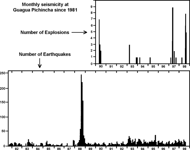 |
Figure 9. Monthly seismicity recorded at Guagua Pichincha from September 1981 through August 1998; however, the earthquakes comprising the August 1998 seismic swarm discussed above were omitted. Monthly explosions detected seismically since January 1990 are shown in the top diagram. Eruptions occurred on the NE side of the lava dome beginning in 1981, 1985, 1990, and several times between 1993 and 1998. The 1988 seismic increases (bottom) failed to lead to an eruption. Courtesy of the Instituto Geofísico. |
Geological Summary. Guagua Pichincha and the older Pleistocene Rucu Pichincha stratovolcanoes form a broad volcanic massif that rises immediately W of Ecuador's capital city, Quito. A lava dome grew at the head of a 6-km-wide scarp formed during a late-Pleistocene slope failure ~50,000 years ago. Subsequent late-Pleistocene and Holocene eruptions from the central vent consisted of explosive activity with pyroclastic flows accompanied by periodic growth and destruction of the lava dome. Many minor eruptions have been recorded since the mid-1500's; the largest took place in 1660, when ash fell over a 1,000 km radius and accumulated to 30 cm depth in Quito. Pyroclastic flows and surges also occurred, primarily to then W, and affected agricultural activity.
Information Contacts: Instituto Geofísico, Escuela Politécnica Nacional, Apartado 2759, Quito, Ecuador; El Comercio newspaper, Quito, Ecuador (URL: http://www.elcomercio.com); El Universo newspaper, Quito, Ecuador (URL: http://www.eluniverso.com); La Hora newspaper, Quito, Ecuador (URL: http://www.lahora.com).