Report on Ol Doinyo Lengai (Tanzania) — September 1998

Bulletin of the Global Volcanism Network, vol. 23, no. 9 (September 1998)
Managing Editor: Richard Wunderman.
Ol Doinyo Lengai (Tanzania) New cones, vigorous activity since February
Please cite this report as:
Global Volcanism Program, 1998. Report on Ol Doinyo Lengai (Tanzania) (Wunderman, R., ed.). Bulletin of the Global Volcanism Network, 23:9. Smithsonian Institution. https://doi.org/10.5479/si.GVP.BGVN199809-222120
Ol Doinyo Lengai
Tanzania
2.764°S, 35.914°E; summit elev. 2962 m
All times are local (unless otherwise noted)
From February through August 1998, several visitors to the crater of Ol Doinyo Lengai produced photographs and descriptions of eruptive activity. The following are taken from a summary of those visits provided by Celia Nyamweru, including detailed observations of certain hornitos made by Fred Belton and Chris Weber during their visits in June and August.
Orientation. Figure 51 locates the prominent features in the crater based on a photograph taken on 23 February 1998. A similar sketch map based on a photograph taken in February 1997 from nearly the same perspective appeared in a previous report (BGVN 23:06). Among the conspicuous new features appearing in 1998 are three large hornitos labeled T45, T46, and T47. T45 was described in February 1998 as being "possibly a new cone," but it may have been active as early as December 1997; by August it had grown to a height of ~7 m and was the dominant landmark in the E of the crater. T46 is a broad, darkly colored feature near the T20/T44 cluster. T46 was erroneously identified as T47 in the last Bulletin report. T47 is a tall, very narrow cone with a pointed top. It is located in the south-central area of the crater near the site of T23, which has nearly vanished. The cone cluster known as "A" has completely disappeared beneath recent lava.
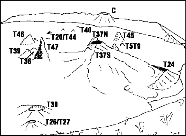 |
Figure 51. View of the crater of Ol Doinyo Lengai looking N from the S crater wall as it appeared 23 February 1998. The oblique view has a variable scale: it is ~ 300 m from T47 to C, and ~ 100 m from T47 to both T37S and T26/T27. Courtesy of C. Nyamweru from a photo by J.S. Antonio. |
General appearance. During a visit to the summit on 12 March, observers noted no major changes to the crater since 23 February. Pale-brown, brown, and gray lava of differing ages covered the floor (figure 52). Pahoehoe flow patterns were clear in some areas, particularly N and NE of T45. An open vent in the T23 area contained a bubbling lava pool and steam issued from various vents. T47 was described as a very tall cone with a vertical crack and sharp peak, making it easily distinguishable from other nearby cones.
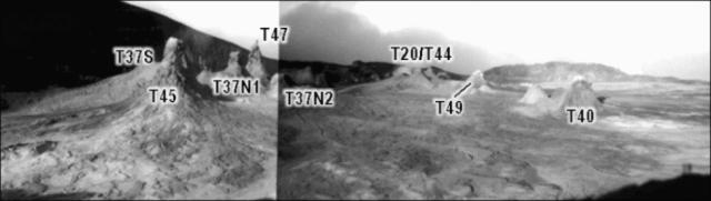 |
Figure 52. Composite panoramic view to the SW from the E crater rim taken on 12 March. T45 is prominent in the foreground. The scale is oblique: it is ~ 150 m from T45 to T47 and ~ 100 m from T45 to T40. Courtesy of C. Nyamweru; photos by B.A. Gadiye. |
An aerial photograph taken during May showed no important changes (figure 53). No steam or fresh lava was seen. The crater floor was covered with white or pale gray lava. A summit visit on 12 June revealed few changes (figure 54). No fresh lavas were seen, but recent flows of gray and brown lava were noticed, particularly in the area of T45 and from T37S in the direction of T24.
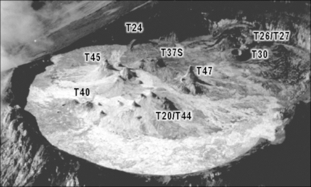 |
Figure 53. Aerial view of the Ol Doinyo Lengai crater looking to the SE in May 1998. Courtesy of C. Nyamweru; photo by B. Wangermez. |
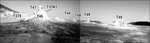 |
Figure 54. Composite panoramic view of Ol Doinyo Lengai looking SW from the E crater rim (compare with figure 52) taken on 12 June. Courtesy of C. Nyamweru; photos by B.A. Gadiye. |
There were no signs of fresh surface activity when observers arrived on 17 June. The entire crater floor was grayish white and mostly soft, and no new spatter was visible on any hornito. The lowest point on the crater rim, to the NW, was 30 cm above the crater floor. T47 was the tallest cone in the crater (~11 m) and was lightly steaming. A 150-m-long steaming fracture, rich in sulfur deposits, was oriented SW-NE; the fracture passed over the site of T41 and T42, both of which had disappeared.
During visits through the first week of August, the steaming fissure was no longer visible, but a new fissure of the same type had developed. This was oriented NW-SE with its SE end located near the base of T20. T37S had two small cones recently added to the S part of its summit and a small lava flow down its W flank. A few clots of lava were ejected from T44C around 1300 on 2 August; although no taller, it showed recently added lava cascades on its N flank. At 0615 on 7 August T44 splashed black liquid lava out of its 6-m-high peak.
T37N1. On 17 June, T37N1 was open to the SE and contained a lava platform consisting of a 2-m-diameter circular pit beneath a 5-m overhanging wall. The pit opened into a cave that was ~4 m deep. A small spatter cone, 4 m W and 2.5 m above the pit, was located on the shoulder of the overhanging wall. At 0630 on 18 June a vigorously sloshing pond of very gas-rich lava rose slowly inside the circular pit. Lava was also visible through the vent of the spatter cone. Within an hour the pond overflowed and the spatter cone began ejecting lava clots up to 2 m above the cone, eventually producing pahoehoe and aa flows that traveled ~100 m ESE. This activity continued until 1200. At 1815 on 19 June a 20-minute eruption resulted in an overflow of the pond. Continuous lava fountains rose up to 1 m above the spatter cone, covering the flows from the previous day. At 1600 on 20 June an eruption lasting more than 15 hours began with a high-volume pond overflow and explosions every 2 seconds from the spatter cone. By 2245 the explosions had stopped and an orange flame was seen at the cone's vent. Lava continued to pour from the pond all night. A tube-fed flow first traveled N, then curved E as a narrow strip ~80 m long containing a single tube, and finally spread out into a wide stacked flow-field that piled up against the E rim.
At 1800 on 5 August a lava lake was seen in the cave under the spatter cone, ~5 m below the rim. At 1930 the lake began to glow dull red in the darkness, revealing that the cave was much larger than it had first appeared. The entire T37N1 hornito was hollow with a lake slowly rising inside that flowed toward the SW and entered a westward-directed tube or cave. As the lake rose higher lava appeared on the crater floor at the W base of T37N1, flowing slowly along the bottom of an old tube. Within 10 minutes the lake rose up to vent level and began to slosh over the rim, but lava could no longer be seen on the crater floor. From 2000 to 2330 the lake overflowed numerous times and lava advanced to a point near the base of T5T9. Due to frequent fluctuations in lake level, no long tubes developed; instead the flows were short and thickly stacked.
Similar activity occurred in the early morning hours of 6 August; just before 0715 the lake was ~3 m below the rim of the spatter cone, which had been increased in height and reduced in diameter during the eruption. The open interior of T37N1 filled with lava to a depth of 2 m, completely burying the pit that had contained the overflowing lava pond in June. The T37N1 spatter cone, positioned on the W side of the new, higher lava platform, was taller and had a larger vent than in June. Foaming white to pale gray carbonatite lava splashed out and fed short lava flows a few meters long down the W slope. Its vent opened into a large cave, ~8 m deep. A recent tube-fed flow from the vent extended to the W crater wall. The vesiculation of the gas-rich lava was high. Activity stopped around 1100 causing a 4-m drop of the lava level.
T48. At 0800 on 18 June (while T37N1 was erupting) T48 produced lava fountains up to 3 m high for 10 minutes, forming short aa flows on its N side. Throughout the morning of 19 June it occasionally ejected solid lapilli along with loud puffs of steam. At 2335 that night it began exploding loudly every 2 seconds and produced lava fountains up to 7 m high. After less than 2 minutes of these explosions the fountains decreased in height to 3 m but increased in volume. Each explosion covered the NW half of T48 with a thick layer of spatter that glowed dull red.
By August T48 had increased in height by at least 2 m and had produced many fresh flows extending in all directions. Aerial photographs taken by Benoit Wangermez on 1 August showed several fresh lava flows originating from vents in the approximate location of T48 and T49 extending to the NE and W crater rims. At 1300 on 2 August, low lava fountaining began from the summit vent and within an hour a lava stream was cascading down the nearly vertical SW flank of T48. Over the next 7 hours a large tube formed from the summit down the SW flank. Lava from this tube advanced past the N slope of T20 more than halfway to the WNW crater wall. Near the base of T48 the tube was ~60 cm in diameter and had several skylights from which lava often overflowed. The lava was gas-rich with a surface that appeared to be covered with gray foam.
The eruption continued all night but lava never reached the crater wall. At 0800 on 3 August a close inspection of the vertical lava tube revealed a small crack expelling hot air. Near 1000 the tube ruptured at that point, creating a powerful horizontal lava fountain that played on the N flank and base of nearby T44C. As the rupture progressed, other fountains directed at various angles of inclination developed, and eventually a flow began to form a second tube. The original tube was still full of flowing lava. By 1800 no lava was visible in the skylights. At 1930 a thin lava stream was spraying horizontally from the E side of T48's summit. At 0600 on 4 August T48 was inactive but at 0800 fountains developed on its upper east flank, creating pahoehoe and aa flows that reached the base of T40B. Similar activity continued until 2000. There was no further activity until 2330 on 5 August when a wide lava fountain sprayed horizontally for 20 minutes from just above a small ledge on the E flank, 2 m below the summit.
On 6 August at 1400 lava splashed out of two openings close to the peak of T48. Black, degassed, very liquid lava fed little lava flows reaching 8 m down the E slope. The activity stopped shortly after 1600.
T40. Sloshing lava was heard inside T40 during the entire June visit. During the night of June 19 a pahoehoe flow traveled ~10 m from a small vent in its base. Lava flowed into a cave under a low, broad hornito just NE of T40. This new lava flow was ~1 m thick. The cave had contained an impressive group of white lava stalactites. On 20 June a 3-m2 section of the SW flank collapsed into its interior.
On 2 August at 1000 occasional lava clots were being ejected from T40's summit, but this continued for only ~30 minutes. During the August visit T40 was noisily degassing. The collapse pit that formed on 20 June in the SW flank of T40 was no longer visible, having been filled in by lava. Recent flows extended a short distance SW and SE of T40, partially covering a low mound to the SE. A tall, narrow cone had very recently been formed on the summit of T40 and was the source of several very fresh aa flows extending to the base of T40.
T49. A small cone just NE of T49 extended toward the NW and grew in height between visits. Sloshing lava was frequently heard there. After several earthquakes during the night of 6 August, at 0408 on 7 August a loud explosion blew off the top and N side of T49. Rocks up to 1 m3 were thrown or rolled a few meters. A dark-red lava fountain ~15 m high continued until 0413 with a loud, jet-like noise. Pahoehoe lava with little viscosity (1-5 Pa s) splashed N of T49 and traveled NW. The flow was thin (10-20 cm) and stopped shortly after the end of the eruption. The amount of erupted lava was ~70-100 m3. Lava pearls up to 4 mm diameter and fine ash were blown over 200 m NW.
Geological Summary. The symmetrical Ol Doinyo Lengai is the only volcano known to have erupted carbonatite tephras and lavas in historical time. The prominent stratovolcano, known to the Maasai as "The Mountain of God," rises abruptly above the broad plain south of Lake Natron in the Gregory Rift Valley. The cone-building stage ended about 15,000 years ago and was followed by periodic ejection of natrocarbonatitic and nephelinite tephra during the Holocene. Historical eruptions have consisted of smaller tephra ejections and emission of numerous natrocarbonatitic lava flows on the floor of the summit crater and occasionally down the upper flanks. The depth and morphology of the northern crater have changed dramatically during the course of historical eruptions, ranging from steep crater walls about 200 m deep in the mid-20th century to shallow platforms mostly filling the crater. Long-term lava effusion in the summit crater beginning in 1983 had by the turn of the century mostly filled the northern crater; by late 1998 lava had begun overflowing the crater rim.
Information Contacts: Celia Nyamweru, Department of Anthropology, St. Lawrence University, Canton, NY 13617 USA (URL: http://blogs.stlawu.edu/lengai/); Fredrick A. Belton, 3555 Philsdale Ave., Memphis, TN 38111; Christoph Weber, Kruppstr 171, 42113 Wuppertal, Germany.