Report on Stromboli (Italy) — October 1998
Bulletin of the Global Volcanism Network, vol. 23, no. 10 (October 1998)
Managing Editor: Richard Wunderman.
Stromboli (Italy) Larger explosions in January, August, and September 1998
Please cite this report as:
Global Volcanism Program, 1998. Report on Stromboli (Italy) (Wunderman, R., ed.). Bulletin of the Global Volcanism Network, 23:10. Smithsonian Institution. https://doi.org/10.5479/si.GVP.BGVN199810-211040
Stromboli
Italy
38.789°N, 15.213°E; summit elev. 924 m
All times are local (unless otherwise noted)
Moderate activity prevailed at Stromboli from January to May 1997 (BGVN 22:03). During this period there was a slight decrease in tremor intensity and a slight increase in the number of recorded events (figure 56). Events exceeding the saturation level of the summit seismic station numbered fewer than 10% of the total recorded.
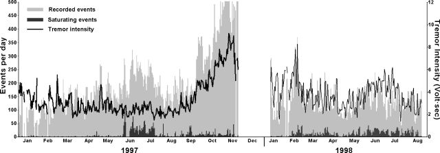 |
Figure 56. Seismicity detected at the summit of Stromboli from January 1997 through August 1998. Gray bars show the number of recorded events/day, and the black bars those saturating the instrument (ground velocity exceeding 100 µm/s). The line shows daily tremor intensity computed by averaging hourly 60-second samples. The seismic station is located 300 m from the craters at 800 m elevation. Courtesy of Roberto Carniel. |
There was a marked increase in the total number of events during June-July 1997, sometimes in excess of 300 per day. Following a month-long lapse, an even larger long-term increase began in September that continued until November 1997. There were several days in this interval when triggering of the seismic station was almost continuous and tremor intensity reached high values, behavior that usually coincided with continuous spattering at the vents. No seismic data were recorded between 24 November 1997 and 9 January 1998. Activity had returned to moderate levels by the time seismic data acquisition resumed on 10 January 1998 (figure 56). The number of daily events rapidly decreased, as did tremor intensity.
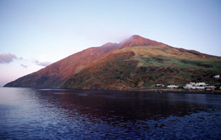
At 1130 on 16 January 1998, a strong explosion in the crater area was similar to others at Stromboli during the last few years; one comparable event occurred on 4 September 1996 (BGVN 22:03). Such explosions are not a danger to the villages of Stromboli and Ginostra (figure 57), but they may be dangerous for tourists visiting the summit because bombs easily reach the usual observation points. Another risk is that fires, started by incandescent bombs, may spread in the vegetation. In the case of the 16 January eruption, bad weather prevented tourists from climbing the volcano and rain extinguished any wildfires.
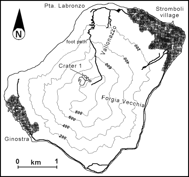 |
Figure 57. Sketch map of Stromboli Island, showing locations referred to in the text. Courtesy of Roberto Carniel. |
A new rise in seismicity began a few days after the explosion. A peak was reached during 16-20 February; on 19 February, 405 events were recorded, and on 20 February tremor intensity was high and 43 saturating events were noted. After this increase, activity decreased steadily with only a few fluctuations until the end of April. The total number of events recorded during the decrease was sometimes
During May-June seismic activity increased. During July two sharp drops in the level of activity were observed: the number of events did not exceed 80 per day during 1-3 July, and went below 50 per day during 22-24 July. Tremor intensity reached the minimum of the year on 22 July. There was a slight upturn in August.
At 1726 on 23 August, another powerful explosion occurred at the craters. The strong blast was heard throughout the island, and a column of ash and lapilli shot over the craters. Incandescent bombs fell over a vast area towards Vallonazzo, Labronzo, and Forgia Vecchia. At least one other explosion followed. Several fires started in vegetation on the upper slopes; the largest one, near Forgia Vecchia, was not extinguished until the next day. Fortunately, although a high number of tourists were on the island, no one was hurt. A dark ash column was eventually replaced by a large, light ash cloud. Small lapilli fell in Ginostra. Bombs were found on the tourist path down to 750 m elevation, and in other directions bombs fell to 500 m. Authorities immediately blocked public access to the upper part of the volcano. The explosion also caused significant morphological changes to the rim of Crater 1 towards Semaforo Labronzo.
Another strong explosion, perhaps more energetic than that of 23 August, happened at 1914 on 8 September. A considerable atmospheric shock wave was reported at the village of Stromboli, and broken windows were reported near San Bartolo. Ash and small lapilli fell near Ginostra and several bush fires were started by bombs on the volcano's slopes. Unfortunately, the seismic station was not operational at the time due to a technical problem.
Stromboli, a small island N of Sicily, has been in almost continuous eruption for over 2,000 years. It is the namesake for small Strombolian explosions, which hurl incandescent scoriae above the crater rim several times a day, with infrequent larger eruptions.
Geological Summary. Spectacular incandescent nighttime explosions at Stromboli have long attracted visitors to the "Lighthouse of the Mediterranean" in the NE Aeolian Islands. This volcano has lent its name to the frequent mild explosive activity that has characterized its eruptions throughout much of historical time. The small island is the emergent summit of a volcano that grew in two main eruptive cycles, the last of which formed the western portion of the island. The Neostromboli eruptive period took place between about 13,000 and 5,000 years ago. The active summit vents are located at the head of the Sciara del Fuoco, a prominent scarp that formed about 5,000 years ago due to a series of slope failures which extends to below sea level. The modern volcano has been constructed within this scarp, which funnels pyroclastic ejecta and lava flows to the NW. Essentially continuous mild Strombolian explosions, sometimes accompanied by lava flows, have been recorded for more than a millennium.
Information Contacts: Roberto Carniel, Dipartimento di Georisorse e Territorio, Universitá di Udine, Via Cotonificio, 114 I-33100 Udine; Jürg Alean, Kantonsschule Zürcher Unterland, CH-8180 Bülach, Switzerland.