Report on Whakaari/White Island (New Zealand) — November 1998

Bulletin of the Global Volcanism Network, vol. 23, no. 11 (November 1998)
Managing Editor: Richard Wunderman.
Whakaari/White Island (New Zealand) Minor eruptive activity continues; alert level raised
Please cite this report as:
Global Volcanism Program, 1998. Report on Whakaari/White Island (New Zealand) (Wunderman, R., ed.). Bulletin of the Global Volcanism Network, 23:11. Smithsonian Institution. https://doi.org/10.5479/si.GVP.BGVN199811-241040
Whakaari/White Island
New Zealand
37.52°S, 177.18°E; summit elev. 294 m
All times are local (unless otherwise noted)
Minor eruptive activity continued at White Island through November and early December. The level of activity varied, but observations during visits and instrumental indicators in early December were sufficient to raise the Alert Level from 1 to 2 on 3 December. The current style of activity was expected to continue for some time.
There was evidence that molten magma was the direct cause of eruptive activity, although only weak volcanic tremor accompanied the ash eruptions. A surveillance visit was made on 1 December to assess the ongoing activity, conduct deformation and magnetic surveys, and collect ash and gas samples.
Observations. The active vent at the base of the NW wall of 1978/90 Crater continued to erupt fine-grained volcanic ash during the 1 December visit. The vent size had not changed since the 2 November visit (BGVN 23:10). During the later visit, an ash-charged, tan-brown convecting plume rose to ~800 m before trailing downwind 10-15 km. The volume of ash in the plume was greater than that observed any time during November. The eruptive activity had deposited up to 45 mm of fine, dark gray and brown ash at the crater rim. Samples of ash that fell on 1 December showed a significant change from ash collected on 23 November and earlier. The 1 December ash samples contained fresh, vesiculated glass, suggesting that magma may have risen in the vent and was contributing directly to the eruption. Previously the ash was derived from solidified lava.
A ground-deformation survey showed a consistent trend of minor inflation across the main crater floor, with continued subsidence near the rim of 1978/90 Crater (figure 34). Large-scale post-1990 inflation was evident at the more distal sites (Pegs C and J), with only minor changes over the last 2-3 months. Collapse about the crater rim, which started in July, was continuing but at a lesser rate (Pegs M and W). Provisional results from the magnetic survey indicated heating at depth and shallow cooling about the crater rim area.
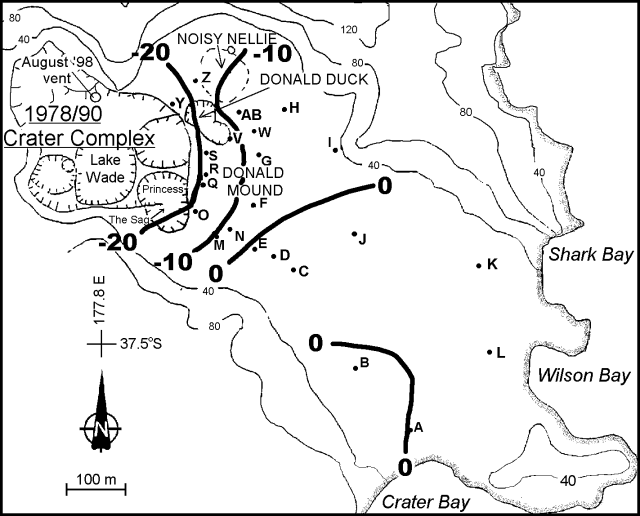 |
Figure 34. Contour plot from White Island showing the height changes (mm) between measurements made 2 November and 1 December 1998. Courtesy IGNS. |
Fumarolic discharge pressures from sites 1, 6a (base of Donald Mound), and 13a were not significantly stronger than those observed on 2 and 16 November, and temperatures remained high at these features: site 1, 124°C; site 6a, 107°C; and site 13a, 120°C. Molten sulfur was found in vents at sites 1 and 13a, which is consistent with the temperatures in excess of 119°C. The sulfur mound at site 1 had grown over the vent during November, suggesting that sulfur was being remobilized from depth in response to elevated temperatures. The discharge at site 6a was mildly superheated, but of high pressure, indicating a relatively high gas content. These observations were consistent with general heating of the hydrothermal system.
The lake, which had reformed in the main crater, was the likely result of recent rains. The lake water was cool (~20°C) and had the brown color of the ash falling into it.
Geological Summary. The uninhabited Whakaari/White Island is the 2 x 2.4 km emergent summit of a 16 x 18 km submarine volcano in the Bay of Plenty about 50 km offshore of North Island. The island consists of two overlapping andesitic-to-dacitic stratovolcanoes. The SE side of the crater is open at sea level, with the recent activity centered about 1 km from the shore close to the rear crater wall. Volckner Rocks, sea stacks that are remnants of a lava dome, lie 5 km NW. Descriptions of volcanism since 1826 have included intermittent moderate phreatic, phreatomagmatic, and Strombolian eruptions; activity there also forms a prominent part of Maori legends. The formation of many new vents during the 19th and 20th centuries caused rapid changes in crater floor topography. Collapse of the crater wall in 1914 produced a debris avalanche that buried buildings and workers at a sulfur-mining project. Explosive activity in December 2019 took place while tourists were present, resulting in many fatalities. The official government name Whakaari/White Island is a combination of the full Maori name of Te Puia o Whakaari ("The Dramatic Volcano") and White Island (referencing the constant steam plume) given by Captain James Cook in 1769.
Information Contacts: B.J. Scott, Manager of Volcano Surveillance, Institute of Geological and Nuclear Sciences (IGNS), Private Bag 2000, Wairakei, New Zealand (URL: http://www.gns.cri.nz/).