Report on Whakaari/White Island (New Zealand) — December 1998

Bulletin of the Global Volcanism Network, vol. 23, no. 12 (December 1998)
Managing Editor: Richard Wunderman.
Whakaari/White Island (New Zealand) New multiple-vent crater forms within 1978/90 crater
Please cite this report as:
Global Volcanism Program, 1998. Report on Whakaari/White Island (New Zealand) (Wunderman, R., ed.). Bulletin of the Global Volcanism Network, 23:12. Smithsonian Institution. https://doi.org/10.5479/si.GVP.BGVN199812-241040
Whakaari/White Island
New Zealand
37.52°S, 177.18°E; summit elev. 294 m
All times are local (unless otherwise noted)
A multiple-vent crater, named Metra, took form on the floor of main 1978/90 crater during 7-11 January. The other active vent (PeeJay) in the main crater formed in August 1998 and continued to emit dense volcanic gas and steam with some volcanic ash. Volcanic tremor levels decreased with the decline in activity at Metra, but remain slightly above typical background for White Island.
A visit was made on 12 January to assess the ongoing activity, conduct a deformation survey, collect ash and gas samples, and service the seismic installation. Results from that visit are reported below. An Alert Level 2 remained; explosive eruptions producing ballistic ejecta are considered possible, particularly if Metra Crater reactivates.
PeeJay vent. The size of PeeJay vent, located at the base of the NW wall of 1978/90 crater (figure 35), had not changed appreciably since a visit in November 1998 (BGVN 23:10 and 23:11). During the January 1999 visit the only generally active vent was PeeJay. It emitted considerable volumes of gas and steam under high pressure, and carried a minor amount of dark gray ash. The plume rose to ~300-350 m before trailing off downwind 10-15 km. The volume of ash contained in the plume was less than that observed over the past month.
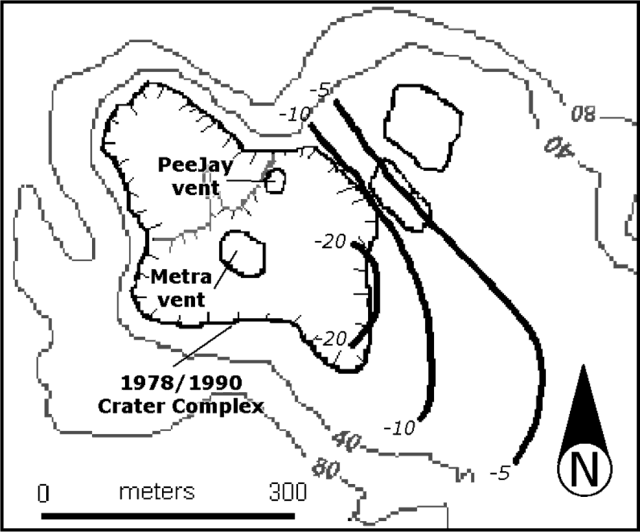 |
Figure 35. Sketch map of the crater area showing the position of the vents and ground deformation contours (heavy black lines; deformations in mm). Courtesy IGNS. |
Measurements made near Peg Z, 140 m ENE of PeeJay, show that about 120 mm of fine ash had accumulated between 1 December 1998 and 12 January 1999, in at least 12 episodes of ashfall, mainly from PeeJay. Near Peg M, 280 m SE of PeeJay, only half that thickness was recorded.
Metra Crater. A considerable portion of the floor of 1978/90 Crater had collapsed, forming a multiple-vent, collapse-crater feature subsequently named Metra Crater (figure 35). The margins of this feature were characterized by scalloped areas that had subsided 5-10 m. On the N side were very fresh cracks in the ground; more collapse was deemed likely in this area. During the visit, Metra was essentially inactive but vivid white steam was emitted (figure 36). The deeper vents in Metra (15-20 m deep) contained pools of muddy, dark gray water and are likely the site of previously observed hydrothermal eruptions. Eruptions from Metra during the period from 7 January, when it was first seen, through 11 January produced a surrounding apron of closely spaced ballistic blocks on the 1978/90 crater floor. Scattered impact craters containing blocks up to 40 cm were seen on the 1978/90 crater rim in areas frequented by visitors, and isolated impacts were noted up to 350 m from Metra near Noisy Nellie. Observations on 17 January confirmed that no eruptions were occurring at Metra Crater; overnight rains had flooded the crater floor.
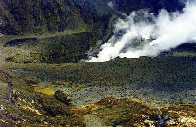 |
Figure 36. Close-up view of the new Metra crater at White Island, which appeared during January 1999. Courtesy IGNS. |
Other observations. The ground deformation survey showed a consistent trend of minor deflation across the main crater floor, with continued subsidence near the rim of 1978/90 Crater. Data from two selected pegs (figure 37) show the large-scale post-1990 inflation and minor deflation over the last 2-3 months.
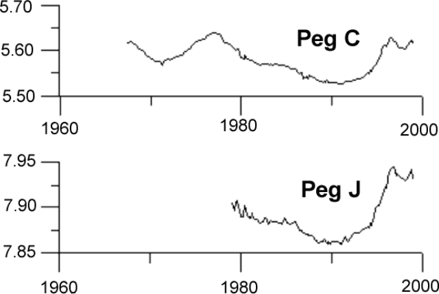 |
Figure 37. Plot showing temporal height changes of two selected pegs at White Island. Heights are in meters. Courtesy IGNS. |
Volcanic tremor declined following the high that accompanied the formation of Metra (figure 38). Afterwards, tremor remained slightly higher than before the formation of the new vents. Tremor levels were low during 11-13 January before dramatically rising to a peak overnight on 14-15 January—the highest levels since those that accompanied the formation of the Metra Crater on 6-7 January. A further peak occurred on the evening of 15 January. Between 1030 and 1500 on 16 January explosive activity at Metra Crater tossed blocks up to 400 m from the crater. Observations from a helicopter operator, who was over the island during 1200-1220, suggested that multiple vents were active, each one erupting differently. Volcanic tremor levels reached a low on the morning of the 17th.
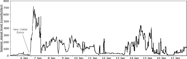 |
Figure 38. Plot showing volcanic tremor at White Island, 5-17 January 1999. Courtesy IGNS. |
Discharge temperatures and characteristics for fumaroles on the main crater floor were little changed from previous measurements made on 1 December. Fumarole ##1 measured 111°C, but tubes removed from the vent were coated in molten sulfur, indicating temperatures in the conduit of at least 119°C. Elemental sulfur continued to accumulate near this and neighboring vents on the S crater wall at high rates. Discharges on Donald Mound and Gully were very weak. Noisy Nellie and ##13a discharge pressures were strong, with temperatures of 134°C and 115°C, respectively.
Geological Summary. The uninhabited Whakaari/White Island is the 2 x 2.4 km emergent summit of a 16 x 18 km submarine volcano in the Bay of Plenty about 50 km offshore of North Island. The island consists of two overlapping andesitic-to-dacitic stratovolcanoes. The SE side of the crater is open at sea level, with the recent activity centered about 1 km from the shore close to the rear crater wall. Volckner Rocks, sea stacks that are remnants of a lava dome, lie 5 km NW. Descriptions of volcanism since 1826 have included intermittent moderate phreatic, phreatomagmatic, and Strombolian eruptions; activity there also forms a prominent part of Maori legends. The formation of many new vents during the 19th and 20th centuries caused rapid changes in crater floor topography. Collapse of the crater wall in 1914 produced a debris avalanche that buried buildings and workers at a sulfur-mining project. Explosive activity in December 2019 took place while tourists were present, resulting in many fatalities. The official government name Whakaari/White Island is a combination of the full Maori name of Te Puia o Whakaari ("The Dramatic Volcano") and White Island (referencing the constant steam plume) given by Captain James Cook in 1769.
Information Contacts: Brad Scott, Wairakei Research Centre, Institute of Geological and Nuclear Sciences (IGNS) Limited, Private Bag 2000, Wairakei, New Zealand (URL: https://www.gns.cri.nz/).