Report on Alamagan (United States) — January 1999
Bulletin of the Global Volcanism Network, vol. 24, no. 1 (January 1999)
Managing Editor: Richard Wunderman.
Alamagan (United States) False eruption report
Please cite this report as:
Global Volcanism Program, 1999. Report on Alamagan (United States) (Wunderman, R., ed.). Bulletin of the Global Volcanism Network, 24:1. Smithsonian Institution. https://doi.org/10.5479/si.GVP.BGVN199901-284180
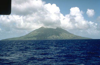
Alamagan
United States
17.6°N, 145.83°E; summit elev. 744 m
All times are local (unless otherwise noted)
News reports from the Commonwealth of the Northern Mariana Islands (CNMI) during 23-24 December indicated that a small group of residents had been evacuated from Alamagan Island by helicopters after the volcano of the same name showed signs of activity. Although five men were taken off the island due to fears of an eruption, an increased volume of steaming apparently led to the false alarm.
Nobody with the technical capability to make a volcanological assessment accompanied the evacuation helicopters, but Greg Guerrero, the Acting Director of the Emergency Management Office discussed the situation with the evacuees and with USGS seismologist Robert Koyanagi in Hawaii. There were no tremors or rumblings felt, and no eruption noises were heard. It is believed that rain penetrating fissures in the volcanic edifice, following a dry period, resulted in a greater than normal amount of steaming. The seismic station installed in 1990 (BGVN 15:09) was not operational due to a lack of funding for batteries. Fieldwork in 1992 (BGVN 17:06) identified one fumarole with a temperature of 72°C.
Reference. Moore, R.B., and Trusdell, F.A., 1993, Geologic map of Alamagan volcano, northern Mariana Islands: U.S. Geological Survey Map I-2408, 1:12,500.
Geological Summary. Alamagan is the emergent summit of a large stratovolcano in the central Mariana Islands with a roughly 350-m-deep summit crater east of the center of the island. The exposed cone is largely Holocene in age. A 1.6 x 1 km graben cuts the SW flank. An extensive basaltic andesite lava flow has extended the northern coast of the island, and a lava platform also occurs on the S flank. Pyroclastic-flow deposits erupted about 1000 years ago have been dated, but reports of historical eruptions were considered invalid (Moore and Trusdell, 1993).
Information Contacts: Greg Guerrero, Emergency Management Office, Commonwealth of the Northern Mariana Islands; Debbie Subera-Wiggins and Jeff Schorr, Insular Affairs Office, Department of the Interior, Washington, DC 20240 USA; Robert Koyanagi, Hawaiian Volcano Observatory (HVO), U.S. Geological Survey, PO Box 51, Hawaii Volcanoes National Park, HI 96718, USA.