Report on Villarrica (Chile) — March 1999
Bulletin of the Global Volcanism Network, vol. 24, no. 3 (March 1999)
Managing Editor: Richard Wunderman.
Villarrica (Chile) Three years of seasonal fluctuations in lava pond height
Please cite this report as:
Global Volcanism Program, 1999. Report on Villarrica (Chile) (Wunderman, R., ed.). Bulletin of the Global Volcanism Network, 24:3. Smithsonian Institution. https://doi.org/10.5479/si.GVP.BGVN199903-357120
Villarrica
Chile
39.42°S, 71.93°W; summit elev. 2847 m
All times are local (unless otherwise noted)
This report summarizes daily visual observations by members of the Proyecto de Observación Villarrica during December 1998 to March 1999. From mid-October through November 1998 team members noted a descent in the lava pond and a drop in visible activity (BGVN 23:11). On 2, 3 and 5 December 1998 a faint red glow was visible above the summit. Afterwards the magma was thought to have reached its lowest level.
When Jürg Alean visited the summit on 21 January, the faint noises caused by degassing could be clearly heard. No recent impacts of bombs were seen in the crater. Early on 5 February, after a break of 2 months, the lava pond reappeared on the crater floor. At about 1300 on 21 February observers saw several dark ash and gas emissions. During 1-26 March the summit remained cloud-covered but apparently little magmatic activity occurred. In the evenings of 29 and 31 March, observers saw glowing pyroclastic material ejected from the crater.
During 1998 the magma column underwent a complete cycle of activity. In January 1998 the column had reached its low; during February-March, the column began slow ascent. From March to September, the column reached hydrostatic equilibrium with its upper surface at the crater floor and this accompanied displays of weak-to-moderate Strombolian eruptions and convective activity in the lava pond. During October-December the column slowly subsided and by January 1999 it again stood at a low level in the vent.
This seasonal sequence has been observed in successive years since 1997 (BGVN 22:04 and 22:08). The seasonal changes in snow and ice mass on the volcano and a well-developed hydrothermal system may affect the magma within the volcanic edifice in a cyclic manner.
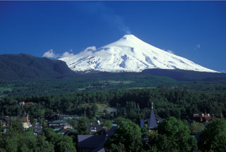
Geological Summary. The glacier-covered Villarrica stratovolcano, in the northern Lakes District of central Chile, is ~15 km south of the city of Pucon. A 2-km-wide caldera that formed about 3,500 years ago is located at the base of the presently active, dominantly basaltic to basaltic andesite cone at the NW margin of a 6-km-wide Pleistocene caldera. More than 30 scoria cones and fissure vents are present on the flanks. Plinian eruptions and pyroclastic flows that have extended up to 20 km from the volcano were produced during the Holocene. Lava flows up to 18 km long have issued from summit and flank vents. Eruptions documented since 1558 CE have consisted largely of mild-to-moderate explosive activity with occasional lava effusion. Glaciers cover 40 km2 of the volcano, and lahars have damaged towns on its flanks.
Information Contacts: Jürg Alean, Stromboli On-Line, Rheinstrasse 6, CH-8193 Egisau, Switzerland (URL: http://www.swisseduc.ch/stromboli/); Werner Keller Ulrich, Proyecto de Observacion Villarrica (P.O.V.I.), Casilla 150, Correo Villa La Reina, Santiago, Chile (URL: https://www.povi.cl/).

