Report on Stromboli (Italy) — June 1999
Bulletin of the Global Volcanism Network, vol. 24, no. 6 (June 1999)
Managing Editor: Richard Wunderman.
Stromboli (Italy) Vents in summit craters still active; variable seismicity
Please cite this report as:
Global Volcanism Program, 1999. Report on Stromboli (Italy) (Wunderman, R., ed.). Bulletin of the Global Volcanism Network, 24:6. Smithsonian Institution. https://doi.org/10.5479/si.GVP.BGVN199906-211040
Stromboli
Italy
38.789°N, 15.213°E; summit elev. 924 m
All times are local (unless otherwise noted)
After the strong summit explosions of 23 August and 8 September 1998 (BGVN 23:10), at least two others followed during 1998: the first at 1805 on 24 November, the second at 0245 on 28 December. Both were reported by Pierre Cottens from the village of Stromboli, with pyroclasts clearly seen from the village, reaching estimated heights of at least 700 m over the craters in November and 500 m in December, but with little ashfall over the village. Technical problems kept the seismic station maintained by the University of Udine out of service through the end of January 1999.
Seismicity during February-June 1999. The seismic station was restored on 1 February 1999, and in the first part of the month the daily number of events declined from 130 to 50-80/day (figure 58). Saturating events showed a similar trend. The second half of February was characterized by an increasing number of events, reaching a maximum of 275 events on 2 March. During this period the tremor intensity showed fluctuations around an average of 3.6 V s, with an isolated peak on 23 February.
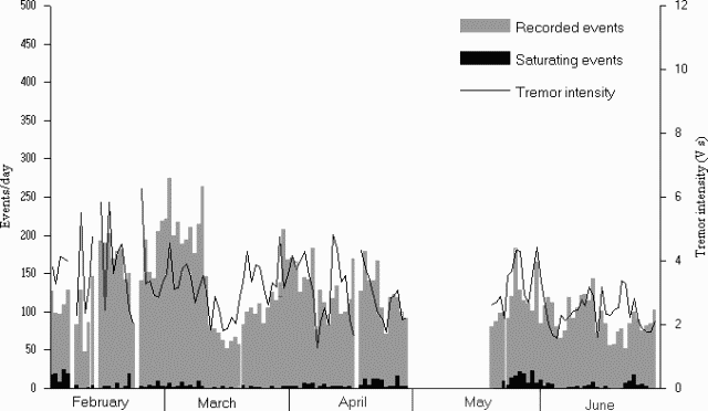 |
Figure 58. Seismicity detected at the summit of Stromboli from February through June 1999. The gray bars show the number of recorded events/day, and the black bars those saturating the instrument (ground velocity exceeding 100 µm/s). The line shows daily tremor intensity computed by averaging hourly 60-second samples. The seismic station is located 300 m from the craters at 800 m elevation. Courtesy of Roberto Carniel. |
During 12-20 March there was a general decrease in activity, with a minimum number of 52 seismic events recorded on 16 March, and a minimum tremor intensity of 1.8 V s on 15 March. The gain in activity was observed first in the tremor intensity, with a local maximum of 4.7 V s on 29 March, then in the number of events, which reached a high of 208 events on 30 March.
A sharp decline was observed on 7 April both in the tremor intensity (from 3.0 to 1.2) and in the number of events (from 180 to 76). Saturating events also stopped, after an average of five saturated events during the three preceding days. Seismic activity increased slightly during the following two days, and on 9 April Cottens reported two strong blasts at about 0300, separated by a few minutes. Bad weather did not allow observation of the summit area, but the noise was similar to that produced by the strong eruptions of 1998. The seismic station recorded an event with greater than usual energy, which may have been from one of the explosions. Another decrease of activity was observed the day after the explosion, with the number of daily events falling to 83 and the tremor intensity to 1.9. The following days were characterized by a slow increase in seismicity, but activity remained low to moderate for the rest of the month.
After another gap in the seismic acquisition, the activity was still low after mid-May 1999, with <100 events/day between 20-24 May. The last week of May showed a rise in the number of events, with a maximum of 183 events on 26 May. A relatively high number of saturating events was also observed, starting on 23 May and peaking on 27 May (21 saturating events) and 30 May (23 saturating events). Another minimum in the number of events (66), number of saturating events (0) and tremor intensity (1.6) was recorded on 5-6 June 1999. During several days on the island in the second half of June, seismic activity remained at low to moderate levels, with a short duration increase in the tremor intensity on 21-22 June.
Observations during 17-20 June 1999. Observations during 17-20 June allowed mapping of the crater terrace (figure 59). Observations were made over two 3-4 hour periods: 2109-0100 (18-19 June), and 2030-2320 (19 June).
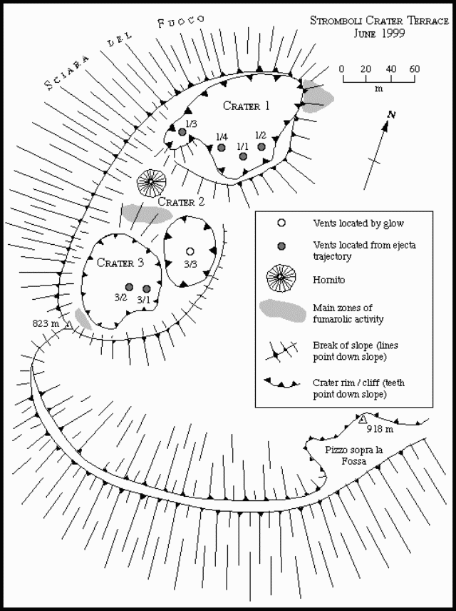 |
Figure 59. Sketch map of Stromboli's Crater Terrace drawn on 18-19 June 1999 from Pizzo sopra la Fossa and fitted to the map produced from a September 1995 EDM survey of the Crater Terrace (BGVN 20:11/12). Courtesy of Andy Harris and Roberto Carniel |
Crater 1 contained four active vents (figure 59). During the first observation period, the vicinity of Vent 1/2 was the source of persistent widespread glow; but no ejecta was observed. Vent 1/1, however, was the source of glow and near-persistent low-energy activity, characterized by repeated phases of ejecta emission separated by periods of little or no emissions. Each phase consisted of numerous pulses of ejecta. During each pulse a few (typically 1-10) bombs were ejected <10 m above the crater rim, with pulses every few seconds. Around 11 periods of this persistent, pulsing emission were observed. Each period lasted 2-29 minutes and was separated by intervals of 3-28 minutes with occasional bomb emissions. This pattern at Vent 1/1 was broken by 16 high-energy events during which explosions sent ejecta ~100 m high.
Vent 1/3 produced high-energy events only, with 18 observed during the first period. High energy events from vents 1/1, 1/3, and 1/4 were synchronized. It was difficult to distinguish eruptions from 1/4 and 1/1 from the viewing angle, so eruptions from these two vents may have been occasionally assigned to the wrong vent; the eruption counts for 1/1 and 1/4 together were therefore combined. Vents 1/3, 1/1, and/or 1/4 erupted together on 11 occasions. On these occasions ejection from each vent was either synchronous or closely linked. During such synchronized events there appeared to be no set order in terms of which of the three vents started erupting and which followed. Vents 1/1 (and/or 1/4) and 1/3 erupted on their own on 5 and 7 occasions, respectively.
As in the first observation period, glow persisted above Vent 1/2 throughout the second period. Unlike the previous evening, however, ejecta was observed from Vent 1/2, where activity followed the style observed at Vent 1/1 during the previous evening. Around eight periods of low-energy but persistent pulsing activity were observed. These lasted 3-33 minutes and were separated by 2-23-minute-long periods of apparently no emission. This pattern of activity from Vent 1/2 was interrupted by five high-energy events lasting 4-6 seconds.
Vent 1/1 issued regular gas puffs (typically one puff every 1-2 seconds), but the frequency of ejecta emission had declined, with the periods of persistent, pulsing activity observed the previous evening replaced by discrete emissions. Ejections were observed from 1/1 on nine occasions, where only one event was of the high-energy type, and the remainder were short (<40-second-long) periods during which 1-10 bombs were ejected <10 m above the rim in pulses. As in the previous period, Vent 1/3 was characterized by high-energy events only. Seven occurred during the second period, of which three were synchronous with high energy events from 1/2 or 1/1.
Although no activity or glow was observed from Crater 2, a hornito (figure 59) had grown in the vicinity of the low cone observed during May 1997 (BGVN 22:05). The area surrounding Crater 2 no longer seemed to be marked by a crater-like feature. The subsidence bowl observed SE of Crater 2 in May 1997 had developed into a deep, funnel-shaped pit, which was the source of faint glow. On a previous map (BGVN 22:05), the vent numbering indicated that this area was part of Crater 2; this interpretation is questionable and this feature could be considered a crater by itself now. On figure 59 we denote this vent as 3/3 (therefore part of Crater 3) in order to allow for easy comparison with older maps of the crater terrace (e.g., BGVN 22:03).
Crater 3 was the location of two additional active vents (figure 59). Glow was observed from vent 3/1 only after an eruption at 2317 on 18 June. Eruptions from Crater 3 were high-energy only, and typically larger (in terms of volume and height, attaining heights of 150 ± 50 m) and longer (lasting 8-23 seconds) than those from Crater 1. Nine and eleven eruptions, respectively, occurred from Crater 3 during the two observation periods.
During our descent in the early hours of 19 June there was a rock fall/slide at about 0200 lasting 1-2 minutes. Boulders from the cliffs on the N edge of the Rina Grande rolled and bounced down the Rina Grande. Owing to the steepness of this flank, once in motion the rocks probably did not stop until they reached the sea in the direction of Forgia Vecchia, crossing the route that descends the Rina Grande ash slope within seconds. Such events pose a very serious hazard to anyone using this route, especially at night.
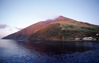
Geological Summary. Spectacular incandescent nighttime explosions at Stromboli have long attracted visitors to the "Lighthouse of the Mediterranean" in the NE Aeolian Islands. This volcano has lent its name to the frequent mild explosive activity that has characterized its eruptions throughout much of historical time. The small island is the emergent summit of a volcano that grew in two main eruptive cycles, the last of which formed the western portion of the island. The Neostromboli eruptive period took place between about 13,000 and 5,000 years ago. The active summit vents are located at the head of the Sciara del Fuoco, a prominent scarp that formed about 5,000 years ago due to a series of slope failures which extends to below sea level. The modern volcano has been constructed within this scarp, which funnels pyroclastic ejecta and lava flows to the NW. Essentially continuous mild Strombolian explosions, sometimes accompanied by lava flows, have been recorded for more than a millennium.
Information Contacts: Andy Harris and Dawn Pirie, Department of Earth Sciences, The Open University, Milton Keynes, MK7 6AA, United Kingdom; Sarah Sherman, 41-485D Kalanianaole Hwy., Waimanolo, HI 96795 USA; Roberto Carniel, Dipartimento di Georisorse e Territorio, Università di Udine, Via Cotonificio, 114, I-33100 Udine (URL: http://www.swisseduc.ch/stromboli/).