Report on Guagua Pichincha (Ecuador) — June 1999

Bulletin of the Global Volcanism Network, vol. 24, no. 6 (June 1999)
Managing Editor: Richard Wunderman.
Guagua Pichincha (Ecuador) Continued frequent steam-and-ash explosions
Please cite this report as:
Global Volcanism Program, 1999. Report on Guagua Pichincha (Ecuador) (Wunderman, R., ed.). Bulletin of the Global Volcanism Network, 24:6. Smithsonian Institution. https://doi.org/10.5479/si.GVP.BGVN199906-352020
Guagua Pichincha
Ecuador
0.171°S, 78.598°W; summit elev. 4784 m
All times are local (unless otherwise noted)
The "yellow alert" status was uninterrupted as Guagua Pichincha expelled steam and ash throughout June. Explosions occurred on 31 May and on 1, 5, 6, 7, 8, 10, 11, 12, 13, 17, 24, 28, and 30 June. Explosions were more frequent in early-to mid-June, but the 28 June explosion was the largest in three months. A large explosion on 11 June sent a steam-and-ash column to ~5 km that lasted for about 5 minutes before dispersing to the south. Explosions were usually accompanied by long periods of tremor. A sulfur smell persisted throughout June and loud noises were also common. Steam frequently escaped to heights between 15 and 1,200 m from vents known as Alineadas, 1981 Crater, and Locomotora, along with those in the NW area of the summit. Alineadas discharged the highest plumes. Phreatic explosions as well as volcano-tectonic (VT), long-period (LP), and hybrid earthquakes occurred almost daily throughout June at levels similar to the last few months (figures 14 and 15). In addition to activity on the volcano, the seismic swarm N of Quito has altered. This may reflect changes in the regional stress field.
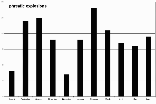 |
Figure 14. Monthly totals at Guagua Pichincha for phreatic explosions from August 1998 through June 1999. Courtesy of Instituto Geofisico. |
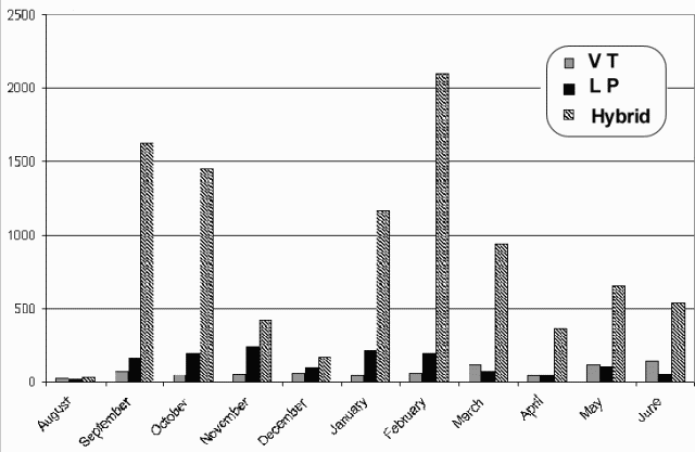 |
Figure 15. Monthly totals at Guagua Pichincha for seismic events (LP, VT, and hybrid) from August 1998 through June 1999. Courtesy of Instituto Geofisico. |
Geological Summary. Guagua Pichincha and the older Pleistocene Rucu Pichincha stratovolcanoes form a broad volcanic massif that rises immediately W of Ecuador's capital city, Quito. A lava dome grew at the head of a 6-km-wide scarp formed during a late-Pleistocene slope failure ~50,000 years ago. Subsequent late-Pleistocene and Holocene eruptions from the central vent consisted of explosive activity with pyroclastic flows accompanied by periodic growth and destruction of the lava dome. Many minor eruptions have been recorded since the mid-1500's; the largest took place in 1660, when ash fell over a 1,000 km radius and accumulated to 30 cm depth in Quito. Pyroclastic flows and surges also occurred, primarily to then W, and affected agricultural activity.
Information Contacts: Instituto Geofísico, Escuela Politécnica Nacional, Apartado 17-01-2759, Quito, Ecuador.