Report on Yasur (Vanuatu) — July 1999

Bulletin of the Global Volcanism Network, vol. 24, no. 7 (July 1999)
Managing Editor: Richard Wunderman.
Yasur (Vanuatu) Relatively quiet interval ends May 1999; bombs ejected up to 600 m beyond rim
Please cite this report as:
Global Volcanism Program, 1999. Report on Yasur (Vanuatu) (Wunderman, R., ed.). Bulletin of the Global Volcanism Network, 24:7. Smithsonian Institution. https://doi.org/10.5479/si.GVP.BGVN199907-257100
Yasur
Vanuatu
19.532°S, 169.447°E; summit elev. 361 m
All times are local (unless otherwise noted)
From April 1998 to April 1999 the activity of Yasur remained very low, but in May 1999 there was renewed strong activity. From the beginning of June until mid-July ejecta (with andesitic bombs up to meter size) was thrown to distances up to 600 m from the nearest edge of the crater (figure 22). This long-range dispersal reflected a change in the direction of the eruptive vents.
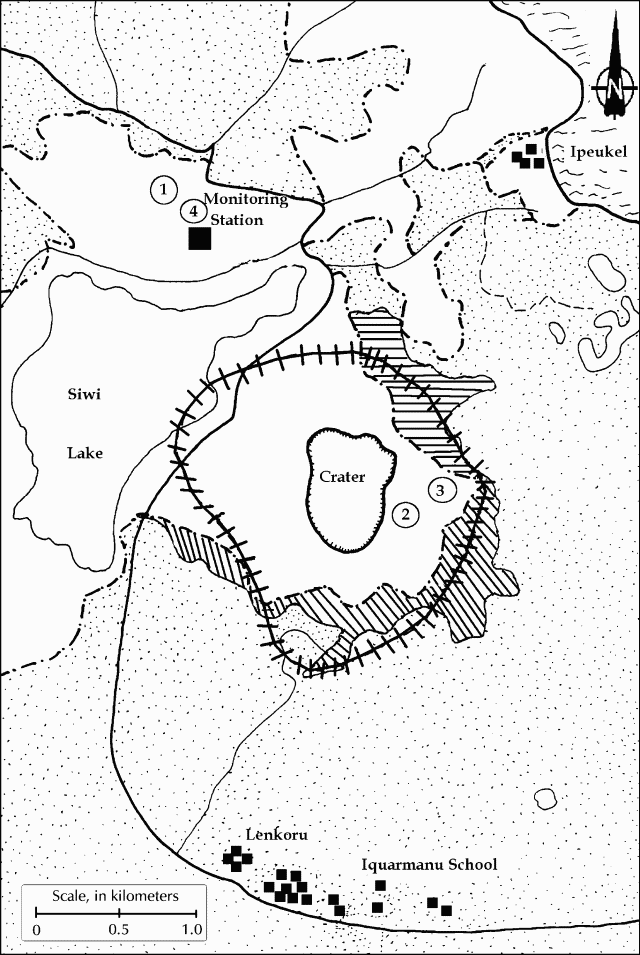 |
Figure 22. A sketch map of Yasur's crater area showing the limit of bomb impacts (the elliptical cross-hatched line), 15 June - 17 July 1999. Vegetation is shown by stipples (dense) and a lined pattern (scattered). Courtesy of Michel Lardy and Douglas Charley. Original base map by A. Mabonlala, IRD. |
The explosive activity was greater than at the beginning of 1994. Based on observations made over the past few years (BGVN 24:04), the emissions of intermittent ash associated with the on-going high explosive activity could continue for a period of months. In early June, half-day-long ashfalls accumulating to 3 mm thickness were noted at distances of up to 2 km from the crater, and in July ashfall occurred to the extreme N of the island.
The activity remains at Type 2, defined as periods of more explosive activity lasting for weeks or months which result in the ejection of bombs in the area surrounding the crater and minor ashfalls which are distributed by the trade winds to the NW and sometimes towards the central part of the island or to the W coast. During such periods access to the crater edge and its surroundings is prohibited due to the frequent, intense fall of bombs.
Geological Summary. Yasur has exhibited essentially continuous Strombolian and Vulcanian activity at least since Captain Cook observed ash eruptions in 1774. This style of activity may have continued for the past 800 years. Located at the SE tip of Tanna Island in Vanuatu, this pyroclastic cone has a nearly circular, 400-m-wide summit crater. The active cone is largely contained within the small Yenkahe caldera, and is the youngest of a group of Holocene volcanic centers constructed over the down-dropped NE flank of the Pleistocene Tukosmeru volcano. The Yenkahe horst is located within the Siwi ring fracture, a 4-km-wide open feature associated with eruption of the andesitic Siwi pyroclastic sequence. Active tectonism along the Yenkahe horst accompanying eruptions has raised Port Resolution harbor more than 20 m during the past century.
Information Contacts: Michel Lardy, Institut de Recherche pour le Développment (IRD), P.O.Box 76, Port Vila, Vanuatu; Douglas Charley, Department of Geology, Mines and Water Resources, PMB 01, Port Vila, Vanuatu.