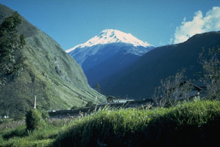
Report on Tungurahua (Ecuador) — October 1999
Bulletin of the Global Volcanism Network, vol. 24, no. 10 (October 1999)
Managing Editor: Richard Wunderman.
Tungurahua (Ecuador) Crisis continues with few earthquakes, abundant tremor, high SO2, and explosions
Please cite this report as:
Global Volcanism Program, 1999. Report on Tungurahua (Ecuador) (Wunderman, R., ed.). Bulletin of the Global Volcanism Network, 24:10. Smithsonian Institution. https://doi.org/10.5479/si.GVP.BGVN199910-352080
Tungurahua
Ecuador
1.467°S, 78.442°W; summit elev. 5023 m
All times are local (unless otherwise noted)
This report briefly summarizes Tungurahua's activity during the period 6-29 October 1999. During this period there was increasing seismicity, particularly tremor, which began in September. Relatively continuous gas emissions also prevailed, with most plumes rising to altitudes of 1-5 km above the summit and extending in various directions as far as 16 km from the volcano.
On 15 October, electronic distance measurements and inclinometer data on the cone's W side indicated an anomalous deformation on the W-NW flanks. That evening a strong collapse of incandescent rocks took place over the higher side of the volcano. A magmatic body was soon seen or inferred very close to the surface below the area of fallen rock. Due to the rapid change in the cone, the Geophysical Institute recommended a change of status from yellow to orange for the most vulnerable zones on the W and SW sides of the volcano. This change was implemented at 0900 on 16 October and prevailed throughout the remainder of the reporting period. That same day pilots were warned of a plume to ~5 km extending to 16 km towards the W. Light ash fell. A flight the next day, 17 October, disclosed an enlarged crater that had expanded by unspecified amounts on its E and SE sides.
On 17 October light ash fell from a plume reaching 3-5 km high. In the afternoon observers saw incandescent rocks on volcano's W side. On 18-24 October plumes were seen by pilots rising to 7-8 km in altitude. Along the highway between the cities of Penipe and Baños recent deposits of two mudflows were found in the Chontapamba and Rea valleys. On 24 October more incandescent rock was seen on the volcano's N side.
Tremor remained at a constantly high level throughout the reporting period but other kinds of seismicity remained relatively low. The most frequently occurring earthquakes, those of long period, typically occurred fewer than 20 times a day. Volcano-tectonic earthquakes and hybrid earthquakes took place less than half as often.
In addition, gas plumes appeared to rise to higher altitudes beginning in mid-October, and incandescent rocks reached distances of 1 km below the volcano summit. Tremor amplitudes grew, saturating seismic stations near the crater and thwarting the ability to recognize local events. This tremor accompanied numerous explosions, 45 being recorded during the last few days of the period.
SO2 fluxes were estimated by either daily COSPEC readings, weather permitting, or sulfuric anhydride measurements, or both. The indicated values ranged from as low as 3,100 to as much as 10,800 tons/day with wide variability (table 1). These high values were taken as indicating elevated magmatic gas, in accord with the observed emissions.
Table 1. Daily values of SO2 flux (metric tons/day) at Tungurahua, 6-27 October 1999. These estimates were based on COSPEC or sulfur anhydrite measurement or both. Plumes on additional days were not measured quantitatively. Courtesy of the Geophysical Institute.
| Date | SO2 flux (metric tons/day) |
| 06 Oct 1999 | 5,600 |
| 07 Oct 1999 | 5,600; 6,400 |
| 08 Oct 1999 | 5,700; 9,300 |
| 09 Oct 1999 | 8,900; 3,300 |
| 10 Oct 1999 | 9,700; 10,800; 5,300; 3,100 |
| 14 Oct 1999 | 4,786 |
| 15 Oct 1999 | 5,000 |
| 23 Oct 1999 | 7,800 |
| 27 Oct 1999 | 7,580 |
Geological Summary. Tungurahua, a steep-sided andesitic-dacitic stratovolcano that towers more than 3 km above its northern base, is one of Ecuador's most active volcanoes. Three major edifices have been sequentially constructed since the mid-Pleistocene over a basement of metamorphic rocks. Tungurahua II was built within the past 14,000 years following the collapse of the initial edifice. Tungurahua II collapsed about 3,000 years ago and produced a large debris-avalanche deposit to the west. The modern glacier-capped stratovolcano (Tungurahua III) was constructed within the landslide scarp. Historical eruptions have all originated from the summit crater, accompanied by strong explosions and sometimes by pyroclastic flows and lava flows that reached populated areas at the volcano's base. Prior to a long-term eruption beginning in 1999 that caused the temporary evacuation of the city of Baños at the foot of the volcano, the last major eruption had occurred from 1916 to 1918, although minor activity continued until 1925.
Information Contacts: Geophysical Institute (Instituto Geofísico), Escuela Politécnica Nacional, Apartado 17-01-2759, Quito, Ecuador.

