Report on Guagua Pichincha (Ecuador) — November 1999

Bulletin of the Global Volcanism Network, vol. 24, no. 11 (November 1999)
Managing Editor: Richard Wunderman.
Guagua Pichincha (Ecuador) Dome growth and explosive eruptions; dramatic increase in LP earthquakes
Please cite this report as:
Global Volcanism Program, 1999. Report on Guagua Pichincha (Ecuador) (Wunderman, R., ed.). Bulletin of the Global Volcanism Network, 24:11. Smithsonian Institution. https://doi.org/10.5479/si.GVP.BGVN199911-352020
Guagua Pichincha
Ecuador
0.171°S, 78.598°W; summit elev. 4784 m
All times are local (unless otherwise noted)
This report covers 22 November through 24 December 1999, an interval when long-period earthquakes increased precipitously. The dome in the caldera's western sector continued to produce explosions, lava extrusions, and rockfalls. November 1999 marked the 32nd month since the unrest began; occasional ashfalls and associated disruptions (minor ashfall, airport closures, hundreds of evacuated refugees) have had a significant impact on Quito residents.
Seismicity. Earthquake hypocenter maps appearing on the Geophysical Institute's website showed the vast majority of earthquakes clustering beneath the crater area; in some cases these clusters also spread W with gradually decreasing density. The website also included a diagrammatic cross section through the crater (figure 20) illustrating the inferred plumbing system, including some typical depths for various kinds of earthquakes. On the inset, the diagram shows an inferred shallow aquifer within the edifice that intersects the active conduit and presumably contributes to the repeated phreatic eruptions.
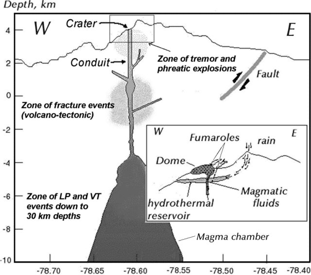 |
Figure 20. A diagrammatic E-W cross-section through the crater at Guagua Pichincha. The cross-section is intended to show the overall internal structure and the zones where the main kinds of earthquakes seen during the crisis have typically originated. The scale across the bottom of the main diagram corresponds to a local coordinate system; the one along the left side of the main diagram indicates depth with respect to sea level (0 km). The inset contains an enlarged view of the crater area. Courtesy of the Geophysical Institute. |
During November 1999 phreatic explosions took place 41 times. Many months during the crisis had fewer than 20 explosions per month, and the November 1999 value was the second highest of the crisis. The highest monthly total occurred during October 1999, a count of 53 explosions.
Seismicity had been escalating rapidly during September-October 1999 (see plot, BGVN 24:10). A precipitous climb in long-period (LP) earthquakes continued during November, reaching dramatic levels (table 7); in September long-period earthquakes occurred ~12,000 times, in October ~15,000 times, and in November ~44,000 times. For another comparison, LP counts earlier in the crisis (July 1998-August 1999) generally remained below 200 earthquakes per month. Thus, compared to this broader interval, the November 1999 count of LP events reflected more than a 200-fold increase. In addition, November's LP earthquakes exceeded the sum for LP events during the previous 16 months.
Table 7. Monthly earthquake counts at Guagua Pichincha representing two key time intervals. The "upper threshold" refers to the highest values registered during the earlier parts of the crisis, July 1998-August 1999. The next three columns indicate the monthly counts during September-November 1999, an interval with the highest numbers of earthquakes yet seen during the current crisis. Courtesy of the Geophysical Institute.
| Earthquake Type | Earlier upper threshold | Sep 1999 | Oct 1999 | Nov 1999 |
| Long-period (LP) | 200 | 11,972 | 15,075 | 43,738 |
| Multi-phase (MP) | 2,099 | 130 | 15,024 | 6,182 |
| Volcano-tectonic (VT) | 160 | 1,331 | 1,701 | 104 |
| Sum (LP + MP) | 12,102 | 30,099 | 49,920 | -- |
A change in the relative numbers of events appears to have occurred beginning in September 1999. From then on, LP events occurred with either similar abundance to MP events, or in some cases LP events became dominant. The total of MP plus LP events (table 2) continued to increase through November 1999.
On the other hand, the escalation in Multiphase (MP) and volcano-tectonic (VT) earthquakes has diminished since the anomalously high values seen in September and October 1999 (table 7, and BGVN 24:10). Compared to earlier in this crisis, MP earthquake counts underwent a sudden peak in October at ~15,000 events; in November there were ~6,000 MP events. VT earthquake counts underwent a less pronounced peak in September and October with ~1,300 and ~1,700 respective events. November VT earthquakes totaled only 104, a value still within the upper end of the monthly counts seen for the bulk of the crisis.
As a result of ongoing dome growth, rockfall-associated seismicity increased. The highest days in September-November had daily LP counts of 250-300 per day. Peaks in dome-growth events approached or exceeded 100 events/day for sustained intervals both during early October and late November 1999.
Daily observations. Tens of daily phreatic explosions were common. Counted seismically, these events appeared so numerous that generally only large ones received much mention in the daily reports (summarized in table 8). On many days visibility into the caldera remained limited because of clouds and fog.
Table 8. Summary of the more important explosions reported at Guagua Pichincha during 22 November-22 December 1999. The explosions discussed here were selected by choosing the Institute's daily reports where the seismically determined parameter of reduced displacement (RD) was reported. Courtesy of the Geophysical Institute.
| Date | Reduced displacement (RD) and related activity and impacts |
| 24 Nov 1999 | Two important explosions, the first of which at 0328 led to ashfall in N Quito visible on clean surfaces such as the exteriors of vehicles. The second explosion took place at 1233 with a RD of 17.7 cm2. The second sent a column to 10 km altitude blowing E (towards Quito). Ash fell (see text). The 1233 explosion vented from the W caldera margin; the associated seismic signal was shallow, 0.9 km. An additional four disturbances occurred between 0840 and 0906 associated with collapse of rocks and consequent emissions in the new dome's W sector; the plumes related to these events rose ~2 km. Still other explosions noted this day had variable RDs: 12.9, 11.8, 2.4, and 1.0 cm2. |
| 25 Nov 1999 | Ash fell on N Quito after explosions at 0528 and 2027 with respective RDs of 15 and 25 cm2. |
| 26 Nov 1999 | An emission with RD of 4.6 cm2 issued an ash-laden column that rose 2 km and dispersed to the SE. |
| 27 Nov 1999 | An emission at 2114 had a RD of 19.6 cm2 and sent an ash column more than 2 km upward; it blew to the W and SW. Heavy cloud cover made it hard to observe the plume, however. Some ash fall was reported in Quito. |
| 29 Nov 1999 | An eruption at 1134 had a RD of 18.9 cm2 and sent an ash column to ~8 km. The next day field crews found block-and-ash flows and mud flows deposited by this eruption on the W flank in the Rio Cristal. |
| 02 Dec 1999 | Two series of explosions took place, the first during 1723-1800 and the second, 2013-2200. An explosion at 2200 had the larger RD, 27.2 cm2. Although clouds obscured the crater, these explosions were thought to have been very destructive to the new dome. |
| 09 Dec 1999 | An eruption with RD of 12 cm2 was termed small; it followed a 10.5-hour interval with 15 eruption signals. |
| 10 Dec 1999 | An explosion with a RD of 26.6 cm2 and subsequent discovery of new pyroclastic flow deposits along the Rio Cristal. Later, at 1713, an explosion with RD of 18 cm2 sent a column to ~7.6 km altitude that was blown to the W and SW. |
| 11 Dec 1999 | Three RDs reported, 15, 16, and 12 cm2, produced by explosions in the early morning hours. Portions of the collapsed dome descended the Rio Cristal and there was some fracturing within the crater's older and newer domes. |
| 14 Dec 1999 | Several small explosions with RDs under 6 cm2. Rockfall seismic signals were common. |
| 15-16 Dec 1999 | Comparatively low-energy explosions with RDs under 4 cm2. |
| 17 Dec 1999 | Three morning explosions after 0730 with successive RDs of 15.5, 23, and 20 cm2. A white mushroom cloud rose to ~8 km altitude above the volcano. Beginning about 1000 a light rain of ash fell on Quito, particularly the north and central parts of the city. The airport shut down in the morning but reopened after 1310. On the W flank mudflows had been spotted carrying blocks up to 3 m in diameter. An additional press release noted a large eruption at 1504 with an RD of 24 cm2 and a resulting column to 8 km above the summit. This was followed by a larger eruption at 1627 with an RD of 28 cm2. By a small margin, this ranked as the largest RD of the reporting interval. After the former eruption close to 14 hours of continuous tremor began. Available wind data around the time of these eruptions suggested that some ash would fall on the Capital, and the next day's report noted light ashfall (thickness unstated but probably under a few millimeters) of fine pumiceous ash in Quito's northern and central zones; on the flanks of the edifice there were tephra clasts of 2-5 cm diameter. |
| 19 Dec 1999 | Minor explosions with RDs under 3 cm2. |
Two explosions on 24 November resulted in significant ashfall on inhabited areas. The latter explosion, around noon, sent a plume to 10 km altitude. Fine ash fell in areas N of Quito, blanketing zones that included the airport, which closed. The ash also affected numerous settlements within a few tens of kilometers N to NE of the summit (including Carcelén, 14.5 km NE; Cotocollao, 9.4 km N; Quito Tenis, 13.5 km NE; and at locations not found on available maps, at la Roldós, La Carolina, Mariscal, and el Ejido). The greatest thicknesses of ash reportedly fell between Jipijapa (unlocated) and la Mariana de Jesús (20.9 km NE).
More events took place the next day, and in the morning ashfalls were reported in Quito's northwestern neighborhoods. The ash lingered in the air well into the next day as a result of disturbances by traffic and cleanup.
An inspection of the W flank on 24 November revealed that during the past week the Cristal river had been inundated by lahars 400 m wide and 10 m deep, although the point of measurement was at an unstated distance from the summit. They were still hot, at least in places, and contained some component of pyroclastic flows bearing carbonized tree-trunks in addition to blocks from the dome. On 30 November observers visiting the Cristal river noted a 1-day-old block-and-ashflow deposit. In the same sector on 8 and 10 December field crews again linked observed zones of burned and singed leaves to probable pyroclastic flows.
On 17 December a white mushroom cloud preceded a dark, ash-bearing one that rose 8-9 km above the volcano. On 18 December, light ash again fell on Quito landing mainly in its central and northern zones. Portions of the cone's flanks received pumice 2-5 cm in diameter. Strong sulfur smells were noted by S-flank residents in Lloa.
An overflight on 21 December enabled the dome height to be estimated at 50-100 m from the base of the caldera. On the dome's W side observers identified a spine, possibly the same one as seen in November. Dark coffee-colored rocks were observed along the E margin of the new dome.
GOES-8 satellite imagery captured plumes on several occasions. For example, it recorded an explosion at about 1140 on 29 November. NOAA analysts estimated the ash plume rose to an altitude of 10-12 km and drifted S toward Tungurahua volcano (which was also producing a faint ash plume). The same ash plume was noted using the "split window" technique, wherein infrared channel 5 (13 µm) is subtracted from infrared channel 4 (11 µm), which often discriminates airborne silicates such as dust and volcanic ash from other features in an image.
During comparatively passive intervals with adequate visibility, daily reports typically described several distinct plumes emitted from the following sources: a) the "aligned" fumaroles (in Spanish, "las alineadas"), b) the fumaroles on the caldera's W border near the head of the Cristal river, c) fumaroles escaping from the 1981 crater, and d) emissions from the top of the new dome. Fumaroles designated as "a" and "b" had plumes that typically reached several hundred meters from base to top; "c" fumaroles typically had plumes that reached tens of meter from base to top.
Radiosondes. According to the Washington Volcanic Ash Advisory Center at NOAA's Satellite Analysis Branch (SAB), during late 1999 and early 2000 authorities in Quito have been launching weather balloons twice a day. The resulting upper atmospheric air movements generally appear on the Geophysical Institute's website. Because these data have been occasionally internally inconsistent in azimuth, they have not yet been incorporated into the modeled data nor the plume trajectory modeling. The SAB has repeatedly seen highly variable winds in the region.
News reports. A brief review of news reports during the past few months revealed numerous stories, some of which were listed on an Ecuadorian Embassy website. ABC News discussed the effects on the explosions of 5-7 October (BGVN 24:09); previously unmentioned in the Bulletin was that the explosion of 5 October caused respiratory problems for many area residents and the death of one man. Four others were injured clearing ash from the roofs of their homes. Quito's Marshal Sucre airport closed for multiple days during the crisis. This not only causes travel problems, but inevitably some commercial aircraft that remain on the ground require cleaning to regain flight worthiness. ABC News also reported that the 24-26 November eruptions that forced one closure of the airport had also caused the Ministry of Education to shut down schools for a few days.
A series of 17-22 November articles in the online Diario Hoy newspaper discussed conditions confronted by 500 refugees from Lloa and neighboring areas living in the largest of several tent cities in a pass above their town. The tent city's amenities included electrical power, water, bathroom facilities, and trash collection; tents came equipped with stoves and beds. The city also provided medical and dental services. Other tent cities provided refuge for ~300 more people. Guards limited access into Lloa, and the town itself was patrolled by the military.
Hoy Digital reported that Quito's mayor, Roque Sevilla, delivered Motorola radios to each one of the leaders of the 35 neighborhoods located on the volcano's slopes as a means of maintaining constant communication with the emergency system locally referred to as "911." The article also mentioned a project developed with the support of the German embassy and the firm Siemens that consists of a system of warning sirens intended to alert citizens of impending danger.
Geological Summary. Guagua Pichincha and the older Pleistocene Rucu Pichincha stratovolcanoes form a broad volcanic massif that rises immediately W of Ecuador's capital city, Quito. A lava dome grew at the head of a 6-km-wide scarp formed during a late-Pleistocene slope failure ~50,000 years ago. Subsequent late-Pleistocene and Holocene eruptions from the central vent consisted of explosive activity with pyroclastic flows accompanied by periodic growth and destruction of the lava dome. Many minor eruptions have been recorded since the mid-1500's; the largest took place in 1660, when ash fell over a 1,000 km radius and accumulated to 30 cm depth in Quito. Pyroclastic flows and surges also occurred, primarily to then W, and affected agricultural activity.
Information Contacts: Geophysical Institute (Instituto Geofísico), Escuela Politécnica Nacional, Apartado 17-01-2759, Quito, Ecuador; Embassy of Ecuador, 2535 15th Street NW, Washington, D.C. 20009 USA (URL: http://www.ecuador.org/); Washington Volcanic Ash Advisory Center, NOAA Satellite Services Division, NESDIS E/SP23, NOAA Science Center, Room 401, 5200 Auth Road, Camp Springs, MD 20746, USA (URL: http://www.ssd.noaa.gov/); ABC News (URL: http://abcnews.go.com/); Diario Hoy, Ecuador (URL: http://www.hoy.com.ec/).