Report on Guagua Pichincha (Ecuador) — December 1999

Bulletin of the Global Volcanism Network, vol. 24, no. 12 (December 1999)
Managing Editor: Richard Wunderman.
Guagua Pichincha (Ecuador) Ongoing dome growth; lahar hazards; 1999 summary
Please cite this report as:
Global Volcanism Program, 1999. Report on Guagua Pichincha (Ecuador) (Wunderman, R., ed.). Bulletin of the Global Volcanism Network, 24:12. Smithsonian Institution. https://doi.org/10.5479/si.GVP.BGVN199912-352020
Guagua Pichincha
Ecuador
0.171°S, 78.598°W; summit elev. 4784 m
All times are local (unless otherwise noted)
This report covers 25 December 1999 through 15 January 2000. The Geophysical Institute released a summary of activity for 1999 as well as a hazards map of Quito showing the likely areas where lahars might enter the city (figure 21). The lahars are expected to chiefly consist of redistributed tephra originally laid down as airfall ash deposits. The map will enable authorities to better understand the likely areas of impact so that they may create plans for lahar cleanup.
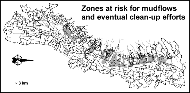 |
Figure 21. A map illustrating a crucial hazard envisioned for Quito-remobilized tephra from Guagua Pichincha eruptions that travel downslope as lahars (shaded areas). Quito, particularly southern Quito, gains protection from a natural barrier formed by the intervening Ungui-El Cinto ridge (which lies along the W margin of the city, i.e. at the top of the figure). The geometry of this barrier accounts for the lack of lahar hazard zones in the southern part of the city. The original map, taken from the Instituto's web site, used color shading and a series of enlarged maps to indicate four levels of hazard (reduced here to one solid gray shading). In addition, streams on the original map appeared in blue and many thus remained distinct from the various hazard designations. Courtesy of the Geophysical Institute. |
Summary of activity during 1999. Activity during 1999 can be divided into two phases: phreatic and magmatic (table 1). The phreatic phase lasted until 23 September. Besides phreatic eruptions it included seismic swarms below the crater and earthquakes felt in Quito. Other differences between the two phases appear on table 9. The largest explosions of the phreatic phase took place on 28 January, 19 and 28 February, 19 May, 28 June, and 24 August. Before July, the phreatic outbursts came from the eastern sector of the 1660 dome; afterwards the sources for the outbursts moved progressively westward, creating new cracks and craters. After August, phreatic explosions gained strength and increased in juvenile ash content, presumably corresponding to the demise of the plug within the conduit.
Table 9. Summary of seismic events during the 1999 phreatic and magmatic phases of activity. Courtesy of the Geophysical Institute.
| Phase | VT | LP | Hybrid | Lloa hybrid | Explosions | Rockfalls | Felt in Quito |
| Phreatic | 1,710 | 1,266 | 45 | 7,524 | 178 | -- | 1,355 |
| Magmatic | 2,520 | 87,055 | 7 | 24,206 | 140 | 3,255 | 132 |
In the magmatic phase eruptions alternately caused growth and destruction of a series of numbered domes (dome 1, dome 2, etc.). The largest explosions during the magmatic phase of 1999 took place on 26 September, 5 October, 26 November, and 3 December.
During October 1999, Guagua Pichincha had the highest number of daily explosions (53) and the first substantial magmatic eruption. Between 2 and 3 October low-level seismicity prevailed, but with increased rockfalls. Slow dome growth and fewer explosions convinced authorities to return to a lower hazard status (to Yellow Alert). Then, on 5 October, came the first substantial eruption to emit juvenile ash-the resulting column rose to 18 km altitude and dispersed NE with some ash landing on Quito and the plume traveling towards Colombia. After a brief hiatus, another eruption occurred on 7 October, this time failing to drop significant ash on Quito.
Seismicity increased after 20 October, peaking during 27 October-8 November at over 3,000 earthquakes a day, in harmony with new dome growth. November surpassed other months in number of earthquakes (43,738).
The destruction of dome 2 occurred on 10 November. A corresponding decrease in seismicity followed, averaging 800 daily earthquakes. Dome 3 was destroyed on 17 November and seismicity afterwards reached 600-700 earthquakes/day. Dome 4 grew next but was subsequently destroyed on 26 November, associated with ashfall on Quito. On 1 December earthquakes reached their peak at 5,000/day. Dome 5 grew next; it was destroyed two days later on 3 December associated with ashfall on Quito. Seismicity next averaged 500 events a day and domes 6 and 7 grew and were destroyed on 10 and 17 December. After the latter event, seismicity dropped considerably, reaching averages of 30 events/day until 31 December. Visual observations, however, disclosed a new batch of magma rising comparatively aseismically, presumably because its conduit offered less resistance to flow. At the time the annual summary was prepared, dome 8 had remained intact for at least a week, possibly surviving into the new year.
Daily reports. Relatively quiet dome growth prevailed during 25 December-15 January, with most of the larger outbursts noted toward the end of this interval. For example, five to six explosions a day took place 11-13 January; their reduced displacements (RD) were under 2 cm2 and the resulting plumes rose up to 2 km above the summit. Fumarolic and less dramatic outbursts generally rose less than ~1.2 km. A helicopter-assisted visit to a geophysical station on the caldera margin revealed that the inclinometer there had suffered the impact of a ~30-cm-diameter incandescent bomb.
Volcano seismicity will be discussed in a future Bulletin report. Two shallow tectonic earthquakes, MR 3.8 and 3.1, took place on 1 and 2 January 2000; both were felt by people in N Quito; the next few days included earthquake swarms in the same region.
During the reporting interval, NOAA aviation notices of plumes were chiefly cautionary rather than announcing any large disturbances. The Embassy of Ecuador is receiving donations for the victims of the country's two volcanic crises, and will continue to do so throughout the emergency. On 1 December, El Commercio newspaper noted an issue not foreseen in the city's emergency plans that came to light after three explosions left a thin layer of airfall ash on the city. The report noted the need to regulate vehicle speeds so as to limit the amount of dust kicked up by passing vehicles.
Geological Summary. Guagua Pichincha and the older Pleistocene Rucu Pichincha stratovolcanoes form a broad volcanic massif that rises immediately W of Ecuador's capital city, Quito. A lava dome grew at the head of a 6-km-wide scarp formed during a late-Pleistocene slope failure ~50,000 years ago. Subsequent late-Pleistocene and Holocene eruptions from the central vent consisted of explosive activity with pyroclastic flows accompanied by periodic growth and destruction of the lava dome. Many minor eruptions have been recorded since the mid-1500's; the largest took place in 1660, when ash fell over a 1,000 km radius and accumulated to 30 cm depth in Quito. Pyroclastic flows and surges also occurred, primarily to then W, and affected agricultural activity.
Information Contacts: Geophysical Institute (Instituto Geofísico), Escuela Politécnica Nacional, Apartado 17-01-2759, Quito, Ecuador; Embassy of Ecuador, 2535 15th Street NW, Washington, D.C. 20009 USA (URL: http://www.ecuador.org/); Washington Volcanic Ash Advisory Center, NOAA Satellite Services Division, NESDIS E/SP23, NOAA Science Center, Room 401, 5200 Auth Road, Camp Springs, MD 20746, USA (URL: http://www.ssd.noaa.gov/); El Commercio newspaper, Quito, Ecuador (URL: http://www.elcomercio.com).