Report on Concepcion (Nicaragua) — February 2000
Bulletin of the Global Volcanism Network, vol. 25, no. 2 (February 2000)
Managing Editor: Richard Wunderman.
Concepcion (Nicaragua) Explosions from the crater cause ashfall in late December
Please cite this report as:
Global Volcanism Program, 2000. Report on Concepcion (Nicaragua) (Wunderman, R., ed.). Bulletin of the Global Volcanism Network, 25:2. Smithsonian Institution. https://doi.org/10.5479/si.GVP.BGVN200002-344120
Concepcion
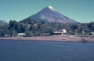
Nicaragua
11.538°N, 85.622°W; summit elev. 1700 m
All times are local (unless otherwise noted)
Starting around dawn on 23 December, INETER registered low-amplitude seismic tremor at the seismic station located at the foot of Concepción. The seismic signal grew gradually and every few minutes small earthquakes were observed. Due to the increasing seismicity, at 1315 on 24 December INETER informed Civil Defense in Managua of the activity and recommended taking precautions for volcanic gases, ashfall, and, in the event of rain, for lahars or mudflows.
On the morning of 27 December INETER received reports from Lacsa and Aviateca airlines that their pilots had observed emission of material from Concepción rising ~300 m above the crater. Residents of Moyogalpa (at the W foot of the volcano) confirmed moderate activity. Minor amounts of gas and volcanic ash blew towards Moyogalpa.
INETER specialists conducted fieldwork around the volcano on 28 December and confirmed the occurrence of low-level eruptive activity based on their own observations and descriptions by local residents. Activity was characterized by sporadic gas explosions from the crater that ejected small amounts W-blown ash. The seismic instrumentation indicated constant tremor with rare volcanic earthquakes related to the crater explosions.
The level of seismicity had decreased by the morning of 29 December, and continued to decline through 1000 on the 30th. Although volcanic activity had also diminished, an explosion at 1600 on 29 December caused ashfall as far as San Jorge (also known as Rivas, a town 25 km SW of Concepción).
Some pilot reports received on 27 December also indicated possible activity from the adjacent Maderas volcano, which has no known historical activity. INETER observers were unable to confirm these reports during fieldwork in the area. However, another seismic station was installed on Ometepe Island in the SW zone of Maderas, which should help to confirm or refute any future reports of Maderas activity.
Geological Summary. Volcán Concepción is one of Nicaragua's highest and most active volcanoes. The symmetrical basaltic-to-dacitic stratovolcano forms the NW half of the dumbbell-shaped island of Ometepe in Lake Nicaragua and is connected to neighboring Madera volcano by a narrow isthmus. A steep-walled summit crater is 250 m deep and has a higher western rim. N-S-trending fractures on the flanks have produced chains of spatter cones, cinder cones, lava domes, and maars located on the NW, NE, SE, and southern sides extending in some cases down to Lake Nicaragua. Concepción was constructed above a basement of lake sediments, and the modern cone grew above a largely buried caldera, a small remnant of which forms a break in slope about halfway up the N flank. Frequent explosive eruptions during the past half century have increased the height of the summit significantly above that shown on current topographic maps and have kept the upper part of the volcano unvegetated.
Information Contacts: Wilfried Strauch and Virginia Tenorio, Dirección General de Geofísica, Instituto Nicaragüense de Estudios Territoriales (INETER), Apartado 1761, Managua, Nicaragua (URL: http://www.ineter.gob.ni/).