Report on Hekla (Iceland) — February 2000
Bulletin of the Global Volcanism Network, vol. 25, no. 2 (February 2000)
Managing Editor: Richard Wunderman.
Hekla (Iceland) Fissure eruption; abundant lava flows produced
Please cite this report as:
Global Volcanism Program, 2000. Report on Hekla (Iceland) (Wunderman, R., ed.). Bulletin of the Global Volcanism Network, 25:2. Smithsonian Institution. https://doi.org/10.5479/si.GVP.BGVN200002-372070
Hekla
Iceland
63.983°N, 19.666°W; summit elev. 1490 m
All times are local (unless otherwise noted)
On 26 February 2000 the WSW-trending, elongated Hekla volcano erupted. A fissure 6-7 km long opened along the SW flank of the Hekla ridge, from which a discontinuous curtain of lava erupted starting at 1819. Just a few minutes later, at 1825, an ash plume reached a height of 11 km and was carried N by light winds. Based on the tremor amplitude the eruption reached peak intensity in the first hour of activity, then gradually declined.
Seismic networks maintained by the Science Institute at the University of Iceland and the Icelandic Meteorological Office recorded short-term precursors. Small earthquakes were first detected by seismographs at various locations during 1655-1707. These gradually increased and the first well-located earthquakes (M 1-2) started at 1729, centered 1-2 km SE of the summit at depths of a few kilometers. A network of borehole strainmeters operated by the Meteorological Office also detected precursory changes associated with magma movements. A decrease in strain build-up rate, signaling a release of magma pressure, was recorded by a strainmeter in a borehole ~15 km from the summit at 1817.
Notice was given to the National Civil Defense and the Civil Aviation Administration about 40 minutes before the eruption, and the public was alerted about the imminent eruption about 15 minutes before it began through national radio broadcasts. Continuous low-frequency tremor began at 1819, at the same time the eruptive cloud was spotted.
Ashfall was reported on 26 February from Grimsey Island, ~70 km off the N coast of Iceland and 300 km N of Hekla. Although small amounts of ash fell in inhabited areas of N Iceland, most fell in uninhabited areas of the island's interior. Seven hours after the eruption's onset the ash deposit 21 km N had a maximum thickness of 4-5 cm.
Lava flows on 27 February covered a large part of the SE flank. That evening a lava stream flowed N from the erupting fissure at a rate of several meters per hour. Another more active lava stream emanated from three craters near the S end of the fissure; the stream was several kilometers long and advancing at ~1 m/minute.
On 28 February an eruption cloud was deflected towards the S by northerly winds. However weather conditions precluded direct observations. Tremor amplitude continued to slowly decline, and the strength of the eruption was decreasing (figure 1). Two eruption clouds were seen at 0500, confirming that activity was ongoing. Although the craters were not visible in the daylight, the most active crater just S of the summit produced three lava streams down the S flanks. Activity in the N declined during the day on 28 February. At 0630 one lava flow had reached the Vatnafjoll mountains at Lambafell, 5 km S of the summit. Advancing at ~2-3 m/hour, the lava front was estimated to be 8-10 m wide. That evening observers watched Strombolian activity in three craters at the southernmost part of the fissure.
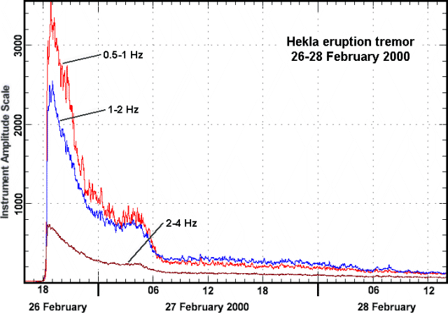 |
Figure 1. Tremor at Hekla during 26-28 February 2000 recorded at Haukadalur, 10 km W. At the beginning of the eruption, 1819 on 26 February, the tremor increased rapidly and reached a maximum at 1850. Tremor then decreased until about 0700 on 27 February and became steady. The tremor was approximately 10 % of the maximum value, on 28 February, but over 10 times greater than the normal value. Courtesy of Páll Halldórsson, Science Institute at the University of Iceland. |
Ashfall was reported on the morning of 29 February 35-40 km S in Fljótshlíð. At 0500 volcanic tremor had started to increase and continued until 1000-1100. By about 0800 all activity in the summit had ceased. During the afternoon of 29 February activity at the southernmost end of the fissure increased again, producing eruption clouds ascending above the summit. In the darkness of the evening, three craters at the southernmost end of the fissure produced lava flowing SW. People watching the lava on the NE flanks reported that they could walk on the stopped flow there.
Vigorous Strombolian eruptions and lava flows on the fissure that cuts the SW slopes were seen during a reconnaissance flight on 1 March during 1100-1230. Four main vents and three smaller vents produced explosions at intervals of 4-5 minutes. At the base of the fissure a large tumuli had developed. The lava streams coming out through the opening of the tumuli joined a stream coming from overflows of the uppermost craters. The S-directed lava flows were fed by the crater closest to the summit. The lava field in the S had only advanced ~100 m since 28 February, but on 1 March it was growing toward the E. By 1 March lava had covered approximately 17 km2.
Increased activity was observed in the upper craters on 2 March, although bad weather persisted from 1200 on 1 March until midday on 3 March. There was also constant steaming from the SW craters, and, compared to 1 March, much larger steam clouds rising from the upper craters. At nightfall explosions were observed at ~30-minute intervals. Glowing lava streams were noted on the flank of the mountain on 2 March.
On 3 March a group of scientists reached the SW lava flow at 1300 and found that the lava front was ~10 m wide and advancing very slowly, ~1-2 m/day. While tracing the lava to the W the group noted that at some places the flow was spreading much faster, up to ~1 m/hour. Following the lava flow along its W side, the group reached its origin at the foot of the volcano, where it emerged from the end of the erupting fissure. At the origin, the estimated flow rate was 0.06 m/s, producing about 10 m3/s of lava. Due to the continuous degassing along the lava stream a blue mist was formed. The blue mist was also observed farther E along the flank of the volcano, indicating that lava was still flowing from the crater close to the summit area. The craters in this region fed the lava flow that moved S toward the Vatnafjoll glacier 10 km SE from Hekla. Later in the evening observers reported that lava was still flowing slowly towards Vatnafjoll. Explosive activity in the uppermost crater of the SW-fissure was characterized by small explosions at 10-20 minute intervals that produced white steam clouds with only trace amounts of ash.
Due to bad weather conditions on 4 March, no direct observations could be made of the eruption. Decreasing eruption tremor was detected. On 5 March the lava flow to the SW was still ongoing according to observations made in the afternoon. At sunset, a red pulsing glow was observed in the uppermost craters of the SW-fissure from the town of Selsundsfjall, 15 km SW. Small eruption clouds were observed on 6 March penetrating the weather clouds covering the summit of Hekla.
During a reconnaissance flight between 1730 and 1830 on 6 March the whole fissure was steaming vigorously and all of the lava flows appeared to have stopped. The lava stream in the SW had left behind an empty channel. Neither incandescence nor explosive activity were observed from the craters. Minor tremors continued on 6-7 March, but may have been related to lava degassing in the feeder dike.
At 0844 on 8 March the last eruptive tremor was detected on seismometers. Based on the end of detectable tremor, and with no signs of new eruptive products since 5 March, it was determined that the eruption ended on the morning of 8 March. Lava covered approximately 18 km2; the preliminary estimate of lava production was 0.11 km3.
Plume investigation. Sulfur dioxide (SO2) contained in plumes from Hekla was detected by the Earth Probe TOMS (Total Ozone Mapping Spectrometer) instrument. TOMS imagery at 1154 on 27 February showed that the volcanic cloud was a narrow plume arcing from the volcano in southern Iceland, then N to Greenland, and finally E towards Norway. The plume primarily contained SO2 because almost all of the ash fell out locally. On 28 February the TOMS imagery indicated that plume stretched out over the Barents Sea and possibly into eastern Russia. By 29 February the SO2 cloud had drifted E in a band along the Norwegian and Russian coasts of the Barents Sea.
During a transit flight on 28 February a SOLVE (SAGE III Ozone Loss and Validation Experiment) mission with an instrument-laden DC-8 aircraft flew through the plume shortly after the eruption ~11.3 km NNE of Iceland at 76°N and 5°W, just off the Greenland coastline. The plume extended up to ~13 km altitude, well into the lower stratosphere. Instruments also measured many in situ trace gases, SO2, HNO3, NO, NOy, O3, and aerosols (volatile and non-volatile), including their size distribution. From about 0508 until 0518 on 29 February the SOLVE aircraft again entered the volcanic cloud. The scientific team reported large enhancements in CN, NOy, HNO3, CO, and particle counts, ozone went to nearly zero, H2O jumped up, and there were strong scattering layers up to 13 km. The plume was a very impressive, orange, airfoil-shaped feature in the pre-dawn sky. The DC-8 engines needed an oil change and new filters after passing through the plume. A flight on 5 March detected enhanced aerosols and SO2 at 1301, but by that time the plume was so diluted that it represented no danger to the aircraft. During the three weeks following the initial encounter the DC-8 detected remnants of the plume trapped within the polar vortex. The resulting analysis concluded that volatile aerosols increased and the sizes of non-volatile large aerosols decreased.
Fluoride analysis. Ash from previous Hekla eruptions has often been the cause of fluorosis in grazing animals. However, during this time of the year most domestic animals are kept indoors, so fluorosis is not expected to become a problem. Freshly fallen ash was measured for soluble fluoride ions (F-). The result was 800-900 mg F/kg. Snow melted by the ash contained about 2,200 mg/l (ppm) of fluoride.
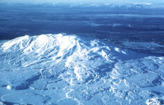
Geological Summary. One of Iceland's most prominent and active volcanoes, Hekla lies near the southern end of the eastern rift zone. Hekla occupies a rift-transform junction, and has produced basaltic andesites, in contrast to the tholeiitic basalts typical of Icelandic rift zone volcanoes. Vatnafjöll, a 40-km-long, 9-km-wide group of basaltic fissures and crater rows immediately SE of Hekla forms a part of the Hekla-Vatnafjöll volcanic system. A 5.5-km-long fissure, Heklugjá, cuts across the 1491-m-high Hekla volcano and is often active along its full length during major eruptions. Repeated eruptions along this rift, which is oblique to most rifting structures in the eastern volcanic zone, are responsible for Hekla's elongated ENE-WSW profile. Frequent large silicic explosive eruptions during historical time have deposited tephra throughout Iceland, providing valuable time markers used to date eruptions from other Icelandic volcanoes. Hekla tephras are generally rich in fluorine and are consequently very hazardous to grazing animals. Extensive lava flows from historical eruptions, which date back to 1104 CE, cover much of the volcano's flanks.
Information Contacts: Freysteinn Sigmundsson, Nordic Volcanological Institute, Grensásvegur 50, IS-108 Reykjavik, Iceland (URL: http://nordvulk.hi.is); Páll Einarsson, Science Institute, University of Iceland, Hofsvallagata 53, IS-107 Reykjavík, Iceland; Ragnar Stefánsson, Icelandic Meteorological Office, Bustadavegur 9, 150 Reykjavík, Iceland (URL: http://www.vedur.is/); Mark Schoeberl, Code 910, NASA/GSFC, Greenbelt, MD, 20771 USA; Michael Fromm, Computational Physics, Inc., 2750 Prosperity Ave., Suite 600, Fairfax, VA 22031 USA (URL: http://cloud1.arc.nasa.gov/solve/); Arlin Krueger, Code 916, NASA/GSFC, Greenbelt, MD, 20771 USA.