Report on Kavachi (Solomon Islands) — April 2000
Bulletin of the Global Volcanism Network, vol. 25, no. 4 (April 2000)
Managing Editor: Richard Wunderman.
Kavachi (Solomon Islands) Scientists aboard a research vessel observe a new submarine eruption
Please cite this report as:
Global Volcanism Program, 2000. Report on Kavachi (Solomon Islands) (Wunderman, R., ed.). Bulletin of the Global Volcanism Network, 25:4. Smithsonian Institution. https://doi.org/10.5479/si.GVP.BGVN200004-255060
Kavachi
Solomon Islands
8.991°S, 157.979°E; summit elev. -20 m
All times are local (unless otherwise noted)
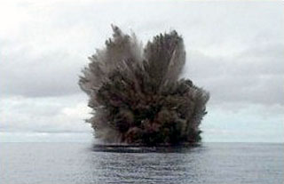
On 14 May 2000 Australian research vessel Franklin visited Kavachi seamount to discover that... a new eruption was underway (figure 6). The vessel was supporting an Australian Commonwealth Scientific and Industrial Research Organization (CSIRO) research cruise (FR04/00) entitled Project SHAARC (Submarine Hydrothermally Active Arc Volcanoes). Upon arrival at 0600 hours observers saw waves breaking on the peak of the volcano. Every 5-7 minutes the scientists on the CSIRO vessel witnessed violent eruptions that lasted 2-3 minutes each, prevailing for the approximately 20 hours that they observed the volcano. The position of the eruption column was fixed specifically at 8.99°S, 157.97°E, and the volcano's peak was estimated at 2-5 m below the water surface. The eruptions ejected ash and incandescent blocks of lava up to 70 m above the sea surface and sulfurous steam plumes rose to heights of 500 m.
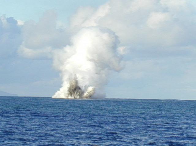 |
Figure 6. Photograph showing an eruption at Kavachi Seamount, 14 May 2000. Courtesy of CSIRO. |
The science team aboard Franklin documented the apparent new phase of island-building eruptive activity. A bathymetric map was produced that differed significantly from the previous map of the volcano made in 1984. Hydrocast/CTD (conductivity-temperature-depth) surveys were undertaken; these detected numerous chemical and particle plumes in the water column; the plumes extended at least 5 km from the eruptive center. Systematic sampling of rocks and ash from the flanks of the volcano returned glassy, vesicular basalts and hydrothermally altered sulfide-rich volcanic breccias. In addition, approximately 500 photographs and 2 hours of digital video captured ~20 eruptions during daylight.
The scientific participants on the CSIRO-led cruise were: Brent McInnes, CSIRO Exploration & Mining Chief Scientist; Richard Arculus, Principal Investigator, and Cromwell Qopoto, Australian National University (ANU); Gary Massoth, Principal Investigator, and Cornel DeRonde, New Zealand Institute of Geological and Nuclear Sciences Ltd (IGNS); Ed Baker, National Oceanic and Atmospheric Administration (NOAA); Pamela Brodie, Dan Conwell, Tim MacConachy, and Ron Plaschke, CSIRO; John Chadwick, University of Florida; and Philip Pousai, University of Papua New Guinea.
Geological Summary. Named for a sea-god of the Gatokae and Vangunu peoples, Kavachi is located in the Solomon Islands south of Vangunu Island. Sometimes referred to as Rejo te Kvachi ("Kavachi's Oven"), this shallow submarine basaltic-to-andesitic volcano has produced ephemeral islands up to 1 km long many times since its first recorded eruption during 1939. Residents of the nearby islands of Vanguna and Nggatokae (Gatokae) reported "fire on the water" prior to 1939, a possible reference to earlier eruptions. The roughly conical edifice rises from water depths of 1.1-1.2 km on the north and greater depths to the SE. Frequent shallow submarine and occasional subaerial eruptions produce phreatomagmatic explosions that eject steam, ash, and incandescent bombs. On a number of occasions lava flows were observed on the ephemeral islands.
Information Contacts: Brent McInnes, Chieft Scientist (FRO4/00), Division of Exploration & Mining, Australian Commonwealth Scientific and Industrial Organization (CSIRO), PO Box 136, North Ryde, NSW 1670, Australia (URL: http://www.csiro.au/).