Report on Kilauea (United States) — April 2000

Bulletin of the Global Volcanism Network, vol. 25, no. 4 (April 2000)
Managing Editor: Richard Wunderman.
Kilauea (United States) An eruptive pause occurred in September; intrusion of magma in February
Please cite this report as:
Global Volcanism Program, 2000. Report on Kilauea (United States) (Wunderman, R., ed.). Bulletin of the Global Volcanism Network, 25:4. Smithsonian Institution. https://doi.org/10.5479/si.GVP.BGVN200004-332010
Kilauea
United States
19.421°N, 155.287°W; summit elev. 1222 m
All times are local (unless otherwise noted)
The period of activity at Kīlauea between 13 September 1999 and May 2000 was marked by multiple lava breakouts that were caused by damming of the lava-tube system. The lava flows traveled from Pu`u `O`o crater, down Pulama pali, and along the coastal plain towards the sea, covering an area several kilometers wide (figure 145).
On 12 September 1999 magma intruded into the upper rift zone of the volcano (BGVN 25:01), with most of it draining underground afterwards leaving a small lava lake near the center of Pu`u `O`o crater. By 16 September the lake was 50-60 m in diameter and ~92 m below the E rim of the crater. From September to mid-October the level of the lava lake was ~63 m below the E rim of the crater with periods of episodic ascent by 10-15 m. During the intrusion and withdrawal of the lava lake a new collapse pit, termed the West Gap Pit, formed in the W gap of the crater. The pit is 30-50 m wide and 12-15 m deep.
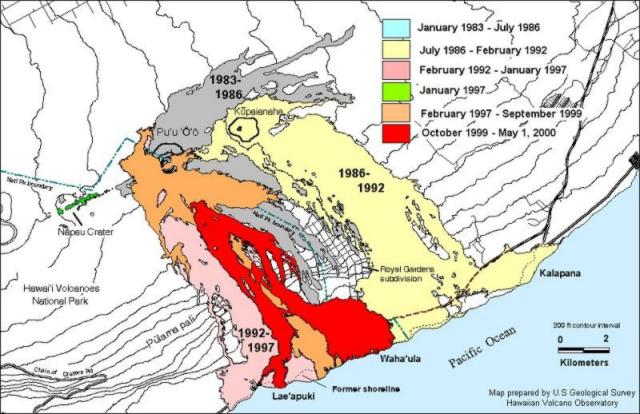 |
Figure 145. Distribution of lava flows from Kīlauea's E rift zone during January 1983-May 2000. Contours are in meters and the contour interval is ~ 150 m. Courtesy of HVO. |
After the intrusion of magma, the 25th eruptive pause of the current eruptive episode (55) occurred when the supply of lava to a well-established lava-tube system, that ended near Kamokuna, stopped. Activity recommenced 23 September when lava erupted from a new spatter cone termed the 'mini-vent,' in Puka Nui collapse pit. Puka Nui is located on the S side of Pu`u `O`o crater. The pit formed in December 1997 and has been growing ever since by the collapse of tephra from the north wall of the pit and by engulfing other cones and smaller pits. Lava had not previously erupted from Puka Nui.
From 12 September through 22 October the lava-tube system was blocked by dams made up of debris that fell from the roof and walls of the tube. After the lava drained from the tube following intrusion, the walls cooled, shrank, and broke, causing the roof to collapse in places and the walls to crumble forming piles of debris. When lava re-entered the system it was blocked by a dam at 530 m elevation and reached the surface through cracks and holes in the tube upstream of the dam. Upslope breakout points were originally thought to be perched ponds (low shield-shaped structures with a pond of lava on top), but because the features were not vents and there was no ponded lava at the sites, they are referred to as breakout points from the lava tube. The lava traveled down Pulama pali towards the sea, but did not reach it. By 16 October activity occurred at the West Gap Pit with spattering from a vent in the floor of the pit, and by 18 or 19 October it filled with lava and overflowed, producing a shelly pahoehoe flow 160 m long.
Over the next several months the lava continued to flow down Pulama pali and just after sunset on 13 December lava reached the sea for the first time since the September intrusion. This took place at Highcastle entry and continued until 17-18 December. On 19 December lava reached the sea at the Lae`apuki lava bench, which had not been active since January 1997. As the lava flowed to the sea, it traveled down the sea cliff with some of it eventually cooling and solidifying to form wonderful examples of lava drapery (structures resembling the drips of wax down a candle). Throughout January lava continued to flow towards the sea causing the Lae`apuki bench to grow. On 3 February a second ocean entry became active at Waha`ula, 4 km E of Lae`apuki. Waha`ula was last active in July 1997 to late 1998.
On 23 February at 0142 tiltmeters at the summit showed a downward tilt toward the caldera (figure 146). The downward tilt indicated that magma was moving out of the summit reservoir; data from two other tiltmeters on the east rift zone indicated that the magma was moving into the rift zone. Concurrently, seismometers recorded a swarm of shallow earthquakes at the upper rift zone of the volcano. The swarm was centered near Pauahi Crater, ~7 km SE of Halema`uma`u Crater along the Chain of Craters Road. Hawaiian Volcano Observatory staff believed that the swarm probably recorded the movement of magma intruding to within 1-2 km of the ground surface. Such swarms commonly precede new fissure eruptions, but they more often record intrusions rather than eruptions. The reversal of the summit tilt a few hours later indicated when the intrusion stopped and magma once again moved into the summit reservoir. No new ground cracks were noted. The intrusion caused minor, but noticeable, changes in the ongoing eruption. Lava continued to enter the tube system at Pu`u `O`o, but blockages in the lava-tube system above the Pulama pali resulted in many breakouts on the active flow field. Lava stopped flowing to Lae`apuki entry on 25 March and intermittent ocean entries began along 2 km of coast centered on Waha`ula, which is currently the main entry.
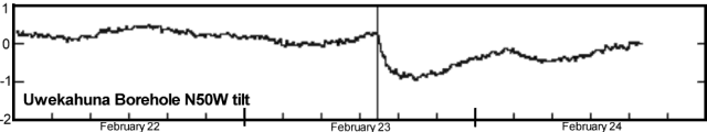 |
Figure 146. Kīlauea tiltmeter record for 22-24 February 2000 at Uwekahuna (tilt along an azimuth of N50W). Courtesy of HVO. |
Geological Summary. Kilauea overlaps the E flank of the massive Mauna Loa shield volcano in the island of Hawaii. Eruptions are prominent in Polynesian legends; written documentation since 1820 records frequent summit and flank lava flow eruptions interspersed with periods of long-term lava lake activity at Halemaumau crater in the summit caldera until 1924. The 3 x 5 km caldera was formed in several stages about 1,500 years ago and during the 18th century; eruptions have also originated from the lengthy East and Southwest rift zones, which extend to the ocean in both directions. About 90% of the surface of the basaltic shield volcano is formed of lava flows less than about 1,100 years old; 70% of the surface is younger than 600 years. The long-term eruption from the East rift zone between 1983 and 2018 produced lava flows covering more than 100 km2, destroyed hundreds of houses, and added new coastline.
Information Contacts: Hawaiian Volcano Observatory (HVO), U.S. Geological Survey, PO Box 51, Hawaii National Park, HI 96718, USA (URL: https://volcanoes.usgs.gov/observatories/hvo/).