Report on Nevado del Huila (Colombia) — May 2000

Bulletin of the Global Volcanism Network, vol. 25, no. 5 (May 2000)
Managing Editor: Richard Wunderman.
Nevado del Huila (Colombia) During February-May, two volcano-tectonic swarms (= M 3.3)
Please cite this report as:
Global Volcanism Program, 2000. Report on Nevado del Huila (Colombia) (Wunderman, R., ed.). Bulletin of the Global Volcanism Network, 25:5. Smithsonian Institution. https://doi.org/10.5479/si.GVP.BGVN200005-351050
Nevado del Huila
Colombia
2.93°N, 76.03°W; summit elev. 5364 m
All times are local (unless otherwise noted)
As shown on figure 5, during February-May 2000 seismic activity on Nevado del Huila volcano included two volcano-tectonic (VT) swarms.
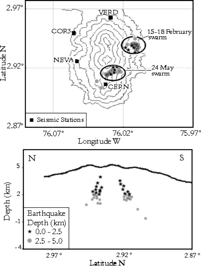 |
Figure 5. Location of seismic swarms on Nevado del Huila volcano during 15-18 February, and 24 May, 2000. Seismic stations are labeled as black boxes. The cross-section runs N - S through the swarms. Pico Sur is the topographic high at the S end of the edifice, just N of the CERN station. Courtesy of Observatorio Vulcanológico y Sismológico de Popayán (INGEOMINAS). |
The first VT swarm occurred during the period 15-18 February and comprised 61 earthquakes located on the E part of the volcano at less than 5 km depth. On 18 February, one M 3.3 earthquake in this swarm was felt in Belalacazar town, 20 km from the volcano.
The second swarm (24 May) lasted for less than two hours and consisted of 90 events located near Pico Sur. Focal depths ranged between 2 and 3 km with magnitudes of M 0.5-2.5; however, the release of energy by the swarm did not exceed normal levels.
Geological Summary. Nevado del Huila, the highest peak in the Colombian Andes, is an elongated N-S-trending volcanic chain mantled by a glacier icecap. The andesitic-dacitic volcano was constructed within a 10-km-wide caldera. Volcanism at Nevado del Huila has produced six volcanic cones whose ages in general migrated from south to north. The high point of the complex is Pico Central. Two glacier-free lava domes lie at the southern end of the volcanic complex. The first historical activity was an explosive eruption in the mid-16th century. Long-term, persistent steam columns had risen from Pico Central prior to the next eruption in 2007, when explosive activity was accompanied by damaging mudflows.
Information Contacts: Fabiola Rodríguez and Jaime Raigosa, Observatorio Vulcanológico y Sismológico de Popayán, INGEOMINAS, Popayán, Colombia; Hector Cepeda, INGEOMINAS, Bogotá, Colombia.