Report on Lokon-Empung (Indonesia) — October 2000
Bulletin of the Global Volcanism Network, vol. 25, no. 10 (October 2000)
Managing Editor: Richard Wunderman.
Lokon-Empung (Indonesia) May-October seismic unrest, modest ash clouds, and lava fountains
Please cite this report as:
Global Volcanism Program, 2000. Report on Lokon-Empung (Indonesia) (Wunderman, R., ed.). Bulletin of the Global Volcanism Network, 25:10. Smithsonian Institution. https://doi.org/10.5479/si.GVP.BGVN200010-266100
Lokon-Empung
Indonesia
1.3644°N, 124.7992°E; summit elev. 1580 m
All times are local (unless otherwise noted)
This report covers activity during March-October 2000. Visual and seismic activity increased notably in mid-March, and the alert level for Lokon-Empung was set at 2 on a scale of 1-4. A very dense gas emission caused vegetation on the eastern slope to wither. During this period, 45 deep volcanic (A-type) earthquakes, 210 shallow volcanic (B-type) earthquakes, and 12 tectonic earthquakes occurred. Tompaluan crater emitted white medium-dense gas that rose 50-150 m above the crater rim in late March. Seismicity changed, with fewer volcanic and more tectonic earthquakes than in the previous weeks. At the beginning of April, the number of A-type earthquakes increased, but visual activity remained similar to the previous week.
The white medium-dense gas emission from Tompaluan crater increased in height to 50-200 m above the rim in the second week of April. B-type earthquakes still dominated seismicity. Seismic intensity of B-type earthquakes increased toward the end of April. Gas emission remained similar, but decreased in height to 50-150 m above the crater rim. During the second week in May, an ash plume rose 100 m above the rim of Tompaluan crater. A volcanic ash advisory was issued on 15 May to warn aviators of the ash cloud emanating from Lokon-Empung. The advisory indicated ash at an altitude of 3,000 m with the potential to rise to 5,600 m and drift to the W. In mid-May, ash explosions increased, sending a white medium-thick plume to 50-200 m above the crater rim. Seismicity peaked with 228 A-type events, 247 B-type events, and 46 tectonic events.
Activity reports did not resume until mid-June, when little visual change took place and seismicity decreased. By the end of June, the white ash plume reached up to 250 m in height, and volcanic earthquakes still dominated the seismicity. White, thin ash explosions reached up to 300 m above the crater rim in late July. Kakaskasen Post Observatory reported a red illumination at the summit, and subsequent observations suggested the operative phenomenon was lava fountaining. The number of volcanic earthquakes decreased, but continuous tremor initiated with amplitudes ranging from 0.5 to 26 mm. The alert level for Lokon-Empung was raised from 2 to 3.
Activity remained similar during 31 July-7 August. White variably dense ash clouds continued to rise to heights of up to 300 m, and lava fountaining up to 25 m above Tompaluan crater was visible during the first week of August. Tectonic earthquakes became dominant, and the amplitude of volcanic tremor reached 0.5 mm. Ash plumes rose to 500 m above the crater rim, and lava fountaining persisted in mid-August. Continuous tremor had amplitudes of 0.5-1 mm. The ash plumes decreased in height to 300 m above the crater the following week. A volcanic ash advisory was issued on 15 August for aviators in the vicinity of Lokon. The number of volcanic earthquakes increased slightly, and tremor decreased in amplitude to 0.5 mm.
Activity increased slightly in September. The ash plume reached progressively higher, ranging from 50 m to 350 m and eventually up to 400 m. Continuous tremor amplitude increased to 0.5-1 mm. Few volcanic earthquakes occurred, so tectonic earthquakes were dominant. The alert level for Lokon-Empung was decreased from 3 to 2 in early October, and activity decreased during the month. The white variably dense ash plume decreased in height to 250 m, although lava fountaining remained visible at a consistent height of 25 m. Seismicity also decreased, and tremor ceased by the end of October.
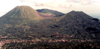
Geological Summary. The Lokong-Empung volcanic complex, rising above the plain of Tondano in North Sulawesi, includes four peaks and an active crater. Lokon, the highest peak, has a flat craterless top. The morphologically younger Empung cone 2 km NE has a 400-m-wide, 150-m-deep crater that erupted last in the 18th century. A ridge extending 3 km WNW from Lokon includes the Tatawiran and Tetempangan peaks. All eruptions since 1829 have originated from Tompaluan, a 150 x 250 m crater in the saddle between Lokon and Empung. These eruptions have primarily produced small-to-moderate ash plumes that sometimes damaged croplands and houses, but lava-dome growth and pyroclastic flows have also occurred.
Information Contacts: Dali Ahmad, Volcanological Survey of Indonesia (VSI), Jalan Diponegoro No. 57, Bandung 40122, Indonesia (URL: http://www.vsi.esdm.go.id/); Darwin Volcanic Ash Advisory Centre (VAAC), Bureau of Meteorology, Northern Territory Regional Office, PO Box 40050, Casuarina, NT 0811, Australia (URL: http://www.bom.gov.au/info/vaac/).