Report on Ulawun (Papua New Guinea) — November 2000
Bulletin of the Global Volcanism Network, vol. 25, no. 11 (November 2000)
Managing Editor: Richard Wunderman.
Ulawun (Papua New Guinea) An eruption during 28 September-2 October 2000 sends a plume to 10-12 km
Please cite this report as:
Global Volcanism Program, 2000. Report on Ulawun (Papua New Guinea) (Wunderman, R., ed.). Bulletin of the Global Volcanism Network, 25:11. Smithsonian Institution. https://doi.org/10.5479/si.GVP.BGVN200011-252120
Ulawun
Papua New Guinea
5.05°S, 151.33°E; summit elev. 2334 m
All times are local (unless otherwise noted)
An eruption from Ulawun that started on 28 September continued until 2 October 2000 (BGVN 25:08). Preliminary information was based on news media reports and aviation sources. The Rabaul Volcano Observatory (RVO) has since provided more accurate and detailed reports for the August-October 2000 period.
Activity during August. During August, summit activity remained low, chiefly consisting of weak releases of thin white vapor. While the summit activity remained quiet, some obvious changes were recorded in seismicity and ground deformation (electronic tiltmeter).
High-frequency earthquakes had occurred sporadically since mid-1998 in very low numbers (~1/day). A brief period of recording in April 2000 registered ~ 2/day. In mid-June 2000, following the resumption of seismic recording, high-frequency earthquakes were first seen to have increased to 15-20/day. This comparatively high number of earthquakes continued through July and August. Deployment of a portable seismograph during 13-15 August indicated these earthquakes had epicenters at Ulawun.
During August, low-frequency earthquakes occurred as usual. On about 26 August, both amplitudes and event counts dropped by a factor of three. Also beginning in August, an electronic tiltmeter located on the flanks ~2.5 km WSW of the crater vent began to show some inflation on the NS component. By month-end about 7 µrad of inflationary tilt was recorded. The EW component (radial to the vent) lacked changes.
Eruption of 28 September-2 October. A relatively small-to-moderate eruption began on 28 September 2000. Several long-term precursors to the eruption were unambiguous. High-frequency earthquakes increased dramatically after June 2000. Electronic tiltmeter trends showed inflation beginning in early August 2000. Short-term, immediate precursors included an increase in both the number of low-frequency earthquakes and the real-time seismic amplitude measurements (RSAM). The latter began to escalate on 27 September 2000.
The late-stage build-up towards the eruption began at 2200 on 27 September with an increase in low-frequency earthquakes and their amplitudes. A further increase in seismicity took place at about 0200 on the 28th. There began a series of small nonharmonic volcanic tremors with durations up to a few minutes. These increased between 1200 and 1800 on the 28th.
The late-stage buildup also appeared in RSAM readings. RSAM values changed at 2200 on the 27th from a background level of 2 units, rising at 1200 on the 28th to ~10 units, then by 1800 to 30 units. After 1800, RSAM values continued to rise and the instruments registered intense continuous volcanic tremor. Around this time the RSAM counts exhibited an artificial decline attributed to an overwhelmed event-counting system.
Other notable changes in the character of the RSAM plot occurred at 2240 on the 28th, and at 0115 and 0240 on the 29th. The first two times correlated with behavior noted by the observer watching the summit crater. Specifically, at 2240 on the 28th the observer saw the first glow reflecting off an ash-cloud emission. RVO scientists mark this as the beginning of the eruption. At 0120 on the 29th, production of incandescent lava fragments intensified, indicating the onset of a Strombolian eruption.
At 0240 on 29 November, the RSAM peaked at 8045 units. Thus, scientists inferred this as the time when the Strombolian phase of the eruption peaked. During the cover of darkness, ash clouds were just visible, initially illuminated by the glow and gradually by incandescent fragments. The latter became common by about 1200 on the 29th when ash clouds were seen blowing NW. The ash clouds began to become voluminous from 0100 on the 29th, coinciding with the intensification of the Strombolian phase of the eruption. The ash clouds were emitted forcefully, accompanied by loud roaring and rumbling noises.
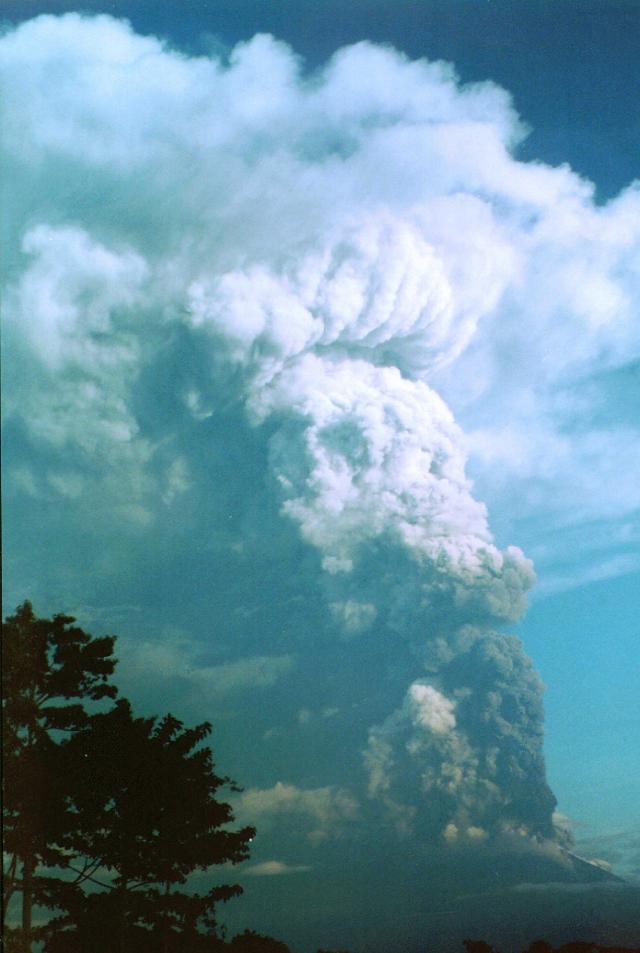
By first light on 29 September people some distance away from Ulawun were able to see a thick vertical eruption column that rose ~12-15 km above the summit (figure 2). In relatively clear morning weather, the eruption column was visible from Rabaul, ~130 km NE of Ulawun. By this time ash clouds had blown WSW to NW. Roaring and rumbling noises ceased at about 1000 and resumed again at about 1300. At about this time also, there was a slight and brief change in wind direction resulting in the eruption's ash clouds being redirected to the N and NE.
The eruption continued into the night of 29 September, forcefully ejecting thick, dark, and ash-laden clouds. Explosive roaring and rumbling noises stopped at about 2200 on 29 September and projections of incandescent lava fragments began to subside at about the same time. By 0230 on 30 September, strong discharges had already stopped and glow at the summit had ceased. When daylight came, the summit activity was relatively quiet, involving only puffs of small dark gray ash clouds. A further decline reduced emissions to very thin white vapor by nightfall.
The eruption produced a moderate amount of ashfall. Ashfall was heavy 10 km downwind of the vent. Beyond that, the amount of ashfall was much reduced, lessening still further away from the vent. The ashfall destroyed gardens and cash-crop plantations within 10 km of its main path. Satellite images of the ash distribution showed that the ash was blown downwind 80-100 km from the vent.
The eruption produced three pyroclastic flows. They traveled down pre-existing gullies on the N, NW, and SE flanks. During past eruptions, pyroclastic flows also followed the same gullies down from the cone's 2,300 m summit elevation. The N-directed pyroclastic flow was the biggest. It descended to 580 m elevation. The NW-directed pyroclastic flow was the second biggest. It divided into two arms at 900 m elevation and its terminus reached an elevation similar to the one on the N flank. The SE flow was relatively small. The eruption lacked lava flows.
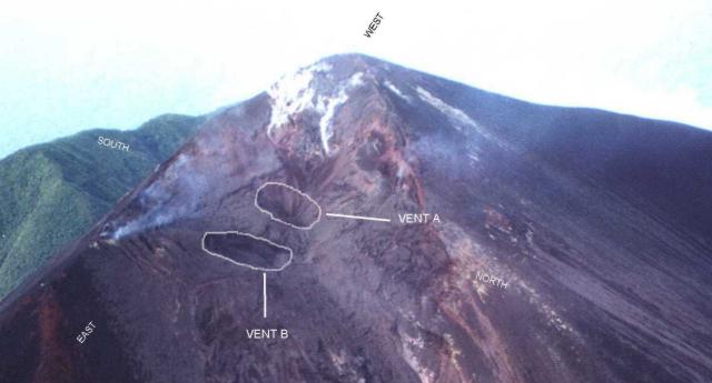
Scientists inspected the crater area from the air on 7 October and found two vents on the summit (labeled Vents A and B on figure 3). Comparing Vent A to its appearance during 1993, the overall depth of the crater floor appeared to have risen, becoming about 100-150 m shallower. The fill consisted of older material that collapsed from the inner crater wall and possibly new ejecta from the current eruption. A prominent breach on the N crater rim was evident and may have been created by the N pyroclastic flow. Judging by its close proximity, this flow originated from Vent B. En-echelon cracks on the E end of the crater suggested inward sagging of that side of the crater rim. At the time of the inspection, few emissions escaped the vents; however, traces of white and blue vapor wafted from other areas inside the crater.
There were reports of multiple vents during past eruptions. However, aerial inspections in 1985 and 1993 only revealed evidence of Vent A. Ulawun had a flank eruption on the SE side during the 1978 eruption.
RVO staff in Rabaul established communication links with the volcano observer based near Ulawun at 1606 on 27 September after noting increased RSAM values. Data from Ulawun were transmitted to RVO every 20 minutes. The RSAM values led to discussions with civil authorities and directions to local residents throughout the night at two-hour intervals. During the process, alert stages one and two were declared. This resulted in evacuating the local population, an effort accomplished with the help of a local timber company. Assistance was later provided by the West New Britain Provincial Government. This time-line of events is contrary to preliminary information (BGVN 25:08). that relied on local news media.
Activity during October. By 3 October the volcano produced only thin white vapor with no noise or night glow. Various ancillary observations occurred in the next weeks: during 6, 8, 10, 14, 15, 16, 17, 18 October and 1 November observers noted low rumbling or banging or both; when under cover of darkness they usually saw accompanying weak, steady glows. In at least one case they smelled sulfurous odors.
The noises at 1000 on 1 November accompanied a thick dark ash cloud that rose 100-200 m above the summit. By 1100 silent ash clouds were seen forcefully rising ~200 m above the summit. Activity then declined for a few hours until 1430-1700, an interval when observers saw thick dark gray ash clouds and occasionally heard weak rumblings. Activity quieted after that and by 2 November emissions had returned to white vapor without noise or night glow.
On 13 and 17 October small mudflows occurred, originating on the upper NW flanks and sweeping down a dry creek through Ubili village and then to the sea. At certain places the flows spread laterally. No reported damage or casualties were caused by either mudflow.
October seismicity included tremor and numerous low-frequency earthquakes. Volcanic tremors were dominant during 1-4, 8-11, and 30-31 October. The low-frequency earthquakes can be characterized by RSAM data. On 1 October RSAM stood at ~30-40 units; steady decline brought the 7 October RSAM to ~5 units. On the 8th and 11th there followed peaks of over 20 units. After that RSAM declined steadily until it reached background levels on 20 October. On 30 October, RSAM underwent a sudden increase to ~20-30 units heralding the brief 1 November eruption.
The single electronic tiltmeter located on the high WSW flank showed a steady change throughout October. The behavior could possibly be related to edifice inflation.
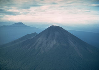
Geological Summary. The symmetrical basaltic-to-andesitic Ulawun stratovolcano is the highest volcano of the Bismarck arc, and one of Papua New Guinea's most frequently active. The volcano, also known as the Father, rises above the N coast of the island of New Britain across a low saddle NE of Bamus volcano, the South Son. The upper 1,000 m is unvegetated. A prominent E-W escarpment on the south may be the result of large-scale slumping. Satellitic cones occupy the NW and E flanks. A steep-walled valley cuts the NW side, and a flank lava-flow complex lies to the south of this valley. Historical eruptions date back to the beginning of the 18th century. Twentieth-century eruptions were mildly explosive until 1967, but after 1970 several larger eruptions produced lava flows and basaltic pyroclastic flows, greatly modifying the summit crater.
Information Contacts: Ima Itikarai, David Lolok, Herman Patia, and Steve Saunders, Rabaul Volcano Observatory (RVO), P.O. Box 386, Rabaul, Papua New Guinea.


