Report on Ol Doinyo Lengai (Tanzania) — December 2000

Bulletin of the Global Volcanism Network, vol. 25, no. 12 (December 2000)
Managing Editor: Richard Wunderman.
Ol Doinyo Lengai (Tanzania) Continued intermittent eruptive activity; scientist burned by lava
Please cite this report as:
Global Volcanism Program, 2000. Report on Ol Doinyo Lengai (Tanzania) (Wunderman, R., ed.). Bulletin of the Global Volcanism Network, 25:12. Smithsonian Institution. https://doi.org/10.5479/si.GVP.BGVN200012-222120
Ol Doinyo Lengai
Tanzania
2.764°S, 35.914°E; summit elev. 2962 m
All times are local (unless otherwise noted)
Activity has continued intermittently since early August 1999 (BGVN 24:11). Celia Nyamweru compiled a report based on observations and interpretations of photographs taken of the crater on various dates between 2 September 1999 and 29 July 2000, and observations made during a 23-26 July 2000 visit to the summit crater. Observations and photos during this period are from the mountain guide Burra Ami Gadiye unless otherwise noted. The report for July 2000 also includes the observations of Fred Belton. A report of fieldwork performed in early October 2000 was prepared by Christoph Weber.
Some cones have been renumbered according to the system agreed on by Nyamweru, Belton, and Weber in October 2000. Under the revised system a new eruption center is assigned a new T-number (e.g. T49). New cones at the flank of an existing cone, and clearly fed by this, will be identified with letters appended to the T-number (e.g T49B, T49C, etc.). This leads to the following renumbering: T52 (formerly T52C), T52B (formerly T52W), T52C (formerly T52E), T37 (formerly T37S), T37B (formerly T37N1), T37C (formerly T37N2), and T37D (formerly T37E and also formerly T5/9). This report reflects the new cone names.
Activity during September-December 1999. Reports and photographs from Gadiye on 2 and 10 September 1999 showed no eruptive activity, almost no dark lava visible, and steaming from cone T47. Colors of the crater floor ranged from white to light gray and light brown, with a slightly darker (chestnut brown) patch of lava around the lower slopes of T45. Small dark patches on the upper slopes of T40 might have been fresh spatter. There were no new cones or significant changes since July 1999. On 10 October Gadiye reported similar activity, plus steam from T37 and T47. A small flat-topped cone W of T37 and T45 may be new, though it is pale gray.
Gadiye's notes from 9 November refer to a cone (most likely T40) throwing out lava. The eruption appeared to be small, with lava bubbling at the top of a hornito on the lower slope of the cone. Some small flows appeared to have come from the central part of the slopes of one or two of the large cones, so possibly there had been some minor activity since 10 October 1999. Joerg Keller reported about a 23 December visit to the crater by Michael Kraml, Ralf Gertisser, Marika Vespa, and Andrea Bull. Patches of relatively fresh looking lava were seen around cones T48 and T49. Between cones T48 and T49 there was a 30-cm-thick layer of natrocarbonatite tear-drop lapilli, relatively fresh in appearance and about a week old. No new cone was present on the W side of the crater floor.
Activity during January-20 July 2000. Gadiye's notes from 2 January refer to "a completely new cone that appeared in December 1999" shown in several photos. In one, he describes it as "throwing out lava violently" although this is not entirely clear from the photograph. This cone, towards the W side of the crater, has been named T51. Most of the crater floor was white to light gray and light brown, with pahoehoe lobes and other well-defined structures. Located close to the W wall, T51 had regular, rather steep slopes and was surrounded with fresh lava. These flows are pahoehoe but appear rather thick in comparison to their length, possibly 10-20 cm thick rather than the 2-5 cm layers observed elsewhere. Emission of steam occurred from several cones in the central cluster.
On 6 January Gadiye noted that very dark fresh-looking lava seemed to originate from a small vent between the E (T37-T45) and W (T47-T49) cone clusters. This may be the beginning of the activity that produced the T52 group described in July 2000. Overall the colors of the crater floor ranged from white to light gray and light brown. The lower slopes of T45 look significantly darker than the pale gray lava surrounding them.
Gadiye's photographs from 24 January showed continued activity from the area between the E and W cone clusters. The source of four long narrow tongues of lava seemed to be a low flat-topped cone between T48 and T37B. Other photographs show a large patch of dark lava between the older cone clusters and possibly a small flow from it towards the NE. Colors of the crater floor ranged from white to light gray, except for the dark patches around T52 and the new flows. The lava at the E overflow was white and showed little or no change since 1999.
Aerial photographs taken on 8 February by Benoit Wangermez showed no visible eruptive activity. No significant changes seemed to have occurred since late January 2000. Gadiye noted no eruptive activity on 12 March. T40 showed little change, there was a small pale brown hornito between T40 and the NW overflow, and T51 was rather pale brown with no sign of dark lava flows around it. Photographs by David Bressler in late April/early May revealed a cone with fresh lava on its slopes, probably T49B. No eruptive activity could be seen on an aerial photograph taken by Nigel Pavitt on 2 May (figure 65). Gadiye also did not report any activity on 7 May. No fresh lava flows were visible in his photographs; the flows originating from the T52 vent(s) were mid-brown in color.
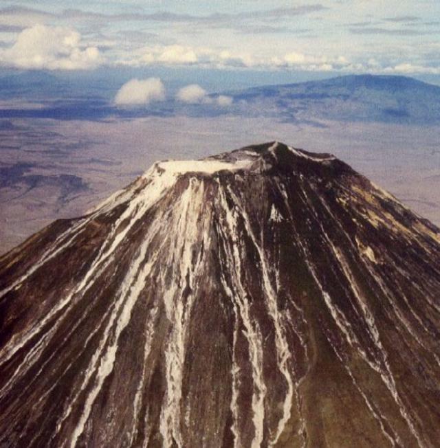 |
Figure 65. An aerial photograph of Ol Doinyo Lengai taken on 2 May 2000 from the W showing the upper part of the cone with Ketumbeine mountain in the background. The summit crater is white, with no details of individual cones visible. The outer walls on the NW and W side are clearly visible, along with the NW overflow, the breakout lava flow of June 1993 on the W wall, and the numerous erosional gullies that expose white ash. The similarity of color between the weathered lava and the weathered ash in the gullies makes it very difficult to determine how far down the slopes the lava flows have extended. Photograph by Nigel Pavitt; courtesy of Celia Nyamweru. |
No activity was obvious in 20 July aerial photographs from Luigi Cantamessa (Geo-Decouverte SA), though some very fresh lava may have been present around T51. A near-vertical view of the crater floor and outer W and NW slopes showed the NW overflow clearly, with very pale brown seeming to extend several hundred meters down the outer slope. The breakout lava flow of June 1993 was also visible on the W slope, and seemed shorter than the NW overflow. A photo taken from over the summit looking N revealed a variety of colors on the crater floor, evidence of many lava flows. One medium-sized brown flow extended S from T46, ending in a broad front of rounded lobes. A near-vertical view with the NW wall in the foreground showed several flows of pale brown and pale gray lava that had moved across the crater rim. The darkest patches on the crater floor were NNW of T49B and W of T51. The patch near T51 was small with very narrow lava tongues radiating outwards. These appeared to be very recent, as such small very narrow flows would not remain dark for very long once the eruption ended.
Activity during 23-30 July 2000. Observations and photographs were made during summit visits by C. Nyamweru (23-26 July) and F. Belton (23-30 July).
Observations made by Nyamweru of the crater floor on 24 July (figure 66) showed that the N part was mostly pale gray, pale brown, or white in color, with no sign of recent lava flows. The youngest lava flows were in the S and E parts of the crater floor. Flow 1, originating from a small vent on the slopes of T46, was probably several weeks old; it still retained its form, pahoehoe surface texture, and a slightly darker brown color than its surroundings. It had recently been partly covered by Flow 2, which was probably less than 24 hours old when Nyamweru's group arrived at the summit on 23 July. On the morning of 23 July it could just be touched with a bare hand; most of the flow was very dark brown with a small amount of whitening around the edges of the slabs. It retained significant warmth and cracking sounds could frequently be heard from within this flow. Flow 2 was ~1.5 m thick with a rough surface composed of broken, tilted pahoehoe slabs, covering much of the S crater floor. It appeared to have originated from the small T37D vent. The lava flowed S and E, surrounding two remnant slabs of the old crater wall and pouring down in a 'lava fall' between T24 and the crater wall to the lower level of the S crater floor. It flowed into T24 and partly buried it, and also flowed around T26, T27, and T30. 'Lava strandlines' were visible around the crater wall E of T24 where the lava lake had been held at a higher level. Flow 3 moved from the N slope of T37B to the N and E to within a few meters of the E overflow. It was still very hot about 1330 on 23 July. Several large blocks of older lava on the upper part of Flow 3 had probably been part of the top of T37B.
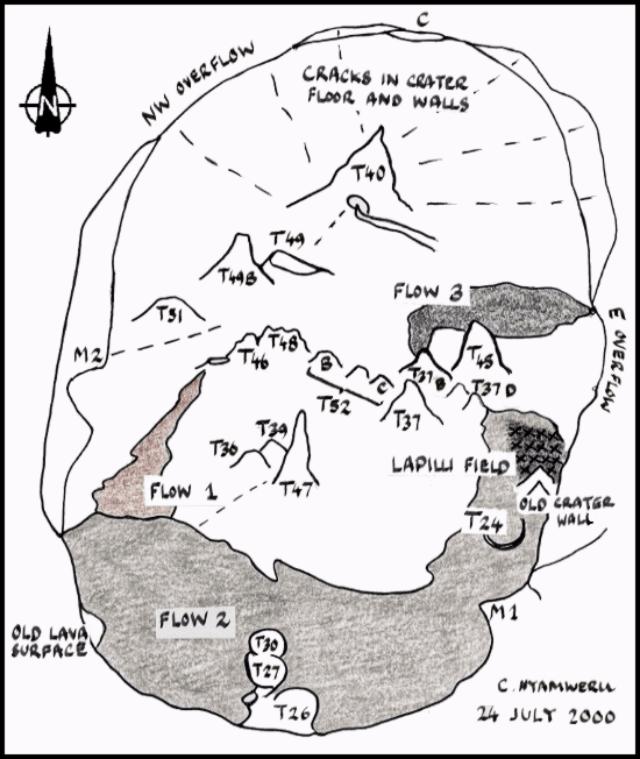 |
Figure 66. A sketch of crater features at Ol Doinyo Lengai made from the summit on 24 July 2000. Notable features include three recent lava flows, large cracks in the crater floor and walls, and a lapilli field. Courtesy of C. Nyamweru. |
The N and W crater floor were crossed by radiating cracks, some of which continued from the floor up through the crater wall. Some of them emitted steam and sulfur fumes, and in places the ground along the cracks was bright yellow with sulfur crystals. Such cracks have long been features of the crater floor, but compared with earlier years there were more of them and they were wider. Nyamweru estimated one crack on the N wall as being ~1 m wide; Belton measured a crack between T40 and T49 and obtained a width of 60 cm and a depth of 4.1 m. Four or five big cracks continued from the floor up onto the N crater wall; this was not something that had been obvious in earlier years. A deep crack extended from T51 across the SW crater floor and up onto the crater wall.
At the NW overflow a photograph taken from the road N of the cone showed what may be a very narrow tongue of white lava (?), not present in July 1999. It appeared to have flowed down a gully in which whitish patches of ash are visible lower down. There is no evidence of major lava flows spilling out of the crater during the last few months, possibly even during the last year. The most recent flows to have crossed the rim may be towards the S end of the overflow, and are small, discolored pahoehoe flows that may have emerged from T51 since January 2000. A crack over 20 cm wide emitting sulfur fumes and steam ran from T49B NW towards the crater rim at the overflow.
In a photograph of the E overflow taken from the road E of the cone no changes were evident since July 1999. However in July 1999 Nyamweru measured the width of this overflow as 22 m, whereas in July 2000 it was 38 m. In July 2000 there was no sign of any fresh lava approaching the overflow apart from Flow 3, which reached within 20 m of the N side of the overflow on 23 July. The low point on the SW rim had changed little since July 1999; small pahoehoe flows from T51 had reached the SW crater wall, but not close to this low point.
T51 was the new cone on the W side of the crater, probably formed in late December 1999. T47/T36/T39 showed little or no change. T46/T44 showed little or no change, but was the source of Flow 1. T48 had collapsed. T49 has been joined by a well-defined cone to its W, called T49B. Three new cones (T52 group) formed E of T48; the western one was a jagged brown cone with no signs of recent activity; the two eastern ones were younger, with smoother shapes and dark gray to black in color, possibly the source of some small lava flows within the last few days. T37B's big open vent had collapsed. The small T37D cone, visible in 1999 photographs, seemed to have been very active in the few days preceding the visit, in particular as the source of Flow 2.
The lapilli field covered an area some tens of meters across, S of T45 and E of T37D. Here the lapilli, well-formed spheres and ovals less than 2 mm in diameter, were black and still warm on 23 July, forming a layer ~8 cm thick. In this area the lapilli overlay some recent lava but in turn were overlain by small pahoehoe flows. Nearby the surface layer of lapilli had already turned white, but below 1-cm depth they were still warm and black. Elsewhere, smaller quantities of lapilli very similar in appearance occurred on the crater floor and on the E crater wall. Lapilli extended ~130 m across the crater floor from the N end of the E overflow, lying in small depressions. In this area the lapilli were pale gray on the afternoon of 23 July. Small amounts of similar gray lapilli were seen on the surface to about a quarter to a third of the way up the SE crater rim.
Belton provided detailed descriptions of the activity at the cones during this period. Activity was nearly continuous at T49B, but varied considerably in nature and intensity. The cone degassed frequently, sometimes emitting loud jets of steam and lava fragments, other times producing a steady output of invisible gases. The degassing alternated with lava splashes that coated the sides of the cone. Eruptions usually occurred 4-5 times per minute. On the night of 23 July cone T49B produced several short aa flows. Rockfall from the top of T49B was also common, with some lava boulders 30 cm in diameter rolling up to 7 m from the base. Throughout the week the summit vent(s) of T49B frequently changed size and location.
The T51 cone built up a low shield in the WNW part of the crater. Lava overflowed from the summit vent of T51 several times during the early morning of 23 July. In a much larger eruption at 1130, lava of very low viscosity cascaded down the N flank and formed pahoehoe flows at its base. A similar but smaller eruption occurred at 1900. From 24 through 27 July cone T51 contained lava at depth (5 m). At 0600 on 28 July a lava pond was 2 m below the rim of the 1-m-diameter summit vent. The pond degassed with increasing vigor and gradually rose closer to the top of the vent. At 1645 lava overflowed the N side, forming channel-fed pahoehoe flows (figure 67). Similar activity continued through the night and into 29 July. Numerous small cones formed above the lava tubes and erupted highly vesicular lava, really nothing more than brown foam. Around 1300 on 29 July surges about once per minute caused the pond to overflow. The eruption continued through 0800 on 30 July (figure 68). One flow traveled 75 m NW to within 16 m of the NW crater rim breach. During the 39 hours of activity, T51 grew in height by at least 1.5 m and its summit vent was reduced in size by ~75%.
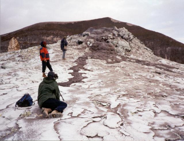 |
Figure 67. Cone T51 in the Ol Doinyo Lengai summit crater overflowed at 1645 on 28 July, sending lava flows down the N and NW slopes. The shape of the small lava shield that T51 has constructed is apparent here. The summit of Ol Doinyo Lengai is just behind the hornito. Courtesy of F. Belton. |
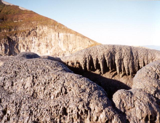 |
Figure 68. Photograph showing the summit area of cone T51 in the crater of Ol Doinyo Lengai on the morning of 29 July. After erupting through the night of 28 July, the lava dropped to a lower level inside T51 by 0800 on the 29th. A climb to the top revealed beautiful lava stalactites around the interior rim of the ~ 1-m-diameter summit vent. Courtesy of F. Belton. |
At around 1300 on 23 July a short (about one minute) unusually violent eruption from T37B sprayed ejecta ~25 m above the cone. It is probable that this activity also created Flow 3, a fast moving 15-cm-thick flow of ropy lava that moved to the E. Minor activity also occurred in this part of the crater on 25 July between about 1500 and 1600 when a 10-m-long pahoehoe flow emerged from a small ground-level vent just E of T37D.
Activity during October 2000. An expedition organized by Chris Weber from 3 to 11 October 2000 consisted of a film team and four scientists, led by Joerg Keller. Observations were made by J. Keller, A. Zaytsev, D. Wiedenmann, J. Klaudius, D. Szczepanski, M. Szeglat, and C. Weber. The best-known track is on the WNW flank. Two other different routes were taken during descents following the visit (figure 69). The track down the NE flank (named Dorobo-Route) and a second track starting halfway between the W crater wall and the summit and descending the WSW flank to pass the Kirurum crater (named Reck-Route) were followed by different expedition members. An overnight camp was made at the Kirurum crater to give time for fieldwork. GPS data and barometric measurements gave new information about the elevations of various points on Ol Doinyo Lengai. The summit peak is approximately 2,955 m (2,950-2,960 m) elevation, cone C on the N crater rim is approximately 2,835 m, and the crater floor was approximately 2,925 m at the NW and E overflows.
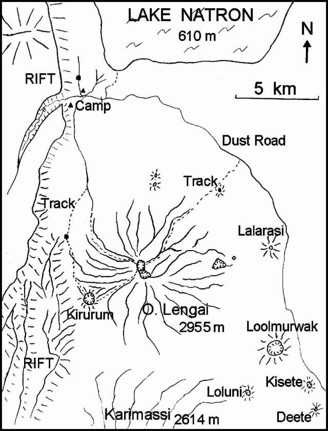 |
Figure 69. Sketch map of the Ol Doinyo Lengai area showing nearby geographic features and climbing routes, October 2000. Courtesy of C. Weber. |
Flow 1 (figure 70) still had a brown appearance, but continued to weather and was lighter in color than on 30 July. The younger Flow 2 was partly black to gray in the joints and cracks of the aa flow field. Some smaller flows around T49 and T49B were slightly black, though probably only a few hours old. Hydration of fresh lava flows (especially under high humidity) can cause a black surface to turn white within 24 hours. NW of T49B another cone appeared after 30 July and was named T49C. T51 was surrounded by flat pahoehoe flows and had grown since 30 July. There was a new cone in the collapsed T48 with some small light gray lava flows close to the cone. During this year many new cracks (at maximum up to 1 m wide and 5 m deep) had opened all across the crater floor. Most of the V-shaped cracks pointed to the T52 and T49 clusters, roughly the center of the major cone concentration. Some of the cracks broke through the crater rim. Other cracks were filled or covered by young lava flows.
 |
Figure 70. Sketch maps of the Ol Doinyo Lengai crater, October 2000, showing cracks (left) and recent lava flows (right). Courtesy of C. Weber. |
Between 1200 and 1350 on 3 October spattering occurred from a small vent in the saddle between T49 and T49B. Two small lava flows were observed at the N and S flank of T49 during that time. At 1350 the W side of T49B collapsed, creating a ~6-m-wide and 5-m-high opening from which a sudden flash flood of lava was released. Parts of the collapsed wall of T49B were washed towards the W as big blocks. Within a few seconds the flow had reached halfway between the cone and the NW overflow. After 5 minutes the flow (Flow 4A) had reached its final extent ~40 m short of the NW overflow (figure 70). The lava flow was up to 5 cm thick and later aa flows were several decimeters thick. Until 8 October lava spattering and small lava flows had nearly closed the gap in the W wall of T49B. On the morning of 9 October at 1035 the W flank again collapsed in the same manner as on 3 October, leaving a 7-m-wide and 7-m-high gap. A flash flood of lava moved NW (Flow 4B) within seconds and stopped just 10 m from the NW overflow, covering Flow 4A. During the afternoon of 9 October T48 had strong degassing and for 10 minutes ejected tear-drop lapilli; no further activity was seen. Right after sunset of 9 October a crack opened at the SSW base of T49C with a noisy gas jet followed by a 10-minute spray of lava droplets and spherical lapilli up to ~10 m high. Small lava flows (Flow 4C) were emitted and moved NW. No more flows were observed through 11 October, but the lava lake inside T49B was splashing and degassing.
Between 3 and 9 October 2000 temperature measurements were made by three different instruments and gave consistent values. A digital thermometer (TM 914C with a K-type stab feeler) was used in the 0-1,200°C mode, taking readings by inserting the feeler 10 cm into still-moving and liquid lavas (10 times on various days) and as deep as possible into the fumaroles (five times on various days). Calibration was by the Delta-T method: values are ± 6°C in the 0-750°C range. All values were recorded by four repeat measurements at one spot. The pahoehoe lava flow (15 m below outflow from the T49B lava pond in an closed lava tube) was at 507°C. An aa flow front in slow motion (shortly after escaping an enclosed lava tube near T49B, 25 cm thick) was 496°C. The fumarole 25 m NNW of T49C in a crater crack towards the rim was at 75°C. The fumarole at the NW overflow inside the old crater rim was at 69°C. The fumarole on the NW flank of T48 was at 95°C.
On the evening of 3 October, one of the scientists (Jurgis Klaudius) accidentally stepped in a fresh but already solid-looking lava flow (~25 cm thick) at the W slope of T49B. This can easily happen in the dark when it is difficult to discern between solid and fresh black flows. In this case it caused a serious second-degree burn around his left ankle up to his lower leg. The lava, at a temperature of about 500°C, burned away all of the light plastic parts of his sport shoe, leaving the leather parts and the sole. On 6 October evacuation was necessary because of the risk of infection. He managed to slide down the steep slopes on his hands and right foot for most of the steep upper track, but was finally carried the rest of the way down in a seat on the shoulders of four porters. He was brought to a hospital in Arusha and then flown to Germany 24 hours later. Klaudius is recovering very well following skin grafts and will not suffer lasting damage.
Lengai is as dangerous as any other active volcano. Activity includes explosive eruptions, suddenly appearing lava fountains, several cone collapses, lava flash floods, and flows of enormous quantity. A lava temperature of 500°C is hot enough to burn someone seriously and because of the very low viscosity, this natrocarbonatite lava is extremely fluid and can flow very fast. Visits are not recommend without a guide.
Geological Summary. The symmetrical Ol Doinyo Lengai is the only volcano known to have erupted carbonatite tephras and lavas in historical time. The prominent stratovolcano, known to the Maasai as "The Mountain of God," rises abruptly above the broad plain south of Lake Natron in the Gregory Rift Valley. The cone-building stage ended about 15,000 years ago and was followed by periodic ejection of natrocarbonatitic and nephelinite tephra during the Holocene. Historical eruptions have consisted of smaller tephra ejections and emission of numerous natrocarbonatitic lava flows on the floor of the summit crater and occasionally down the upper flanks. The depth and morphology of the northern crater have changed dramatically during the course of historical eruptions, ranging from steep crater walls about 200 m deep in the mid-20th century to shallow platforms mostly filling the crater. Long-term lava effusion in the summit crater beginning in 1983 had by the turn of the century mostly filled the northern crater; by late 1998 lava had begun overflowing the crater rim.
Information Contacts: Celia Nyamweru, Department of Anthropology, St. Lawrence University, Canton NY 13617 USA (URL: http://blogs.stlawu.edu/lengai/); Joerg Keller, IMPG, Albert-Ludwig-University Freiburg, Albertstrasse 23b, 79104 Freiburg, Germany; Christoph Weber, Volcano Expeditions International, Friesenstrasse 20, 42107 Wuppertal, Germany (URL: http://www.Vulkanexpeditionen.de); Frederick Belton, 3555 Philsdale Ave., Memphis, TN 38111 USA (URL: http://oldoinyolengai.pbworks.com/); Marc Szeglat (contact for video-film clips), Duelmenerstrasse 11, 46117 Oberhausen, Germany (URL: http://www.vulkane.net).