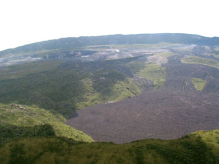
Report on Nyamulagira (DR Congo) — January 2001
Bulletin of the Global Volcanism Network, vol. 26, no. 1 (January 2001)
Managing Editor: Richard Wunderman.
Nyamulagira (DR Congo) Lava flows began erupting in early February; one injury reported
Please cite this report as:
Global Volcanism Program, 2001. Report on Nyamulagira (DR Congo) (Wunderman, R., ed.). Bulletin of the Global Volcanism Network, 26:1. Smithsonian Institution. https://doi.org/10.5479/si.GVP.BGVN200101-223020
Nyamulagira
DR Congo
1.408°S, 29.2°E; summit elev. 3058 m
All times are local (unless otherwise noted)
Nyamuragira, Africa's most active volcano, was the subject of recent reports from USAID/OFDA, volcanic observatories and research centers, Reuters news, and satellite remote-sensing observers. Our last report on Nyamuragira was in late January 2000 (see BGVN 25:01). The volcano is situated about 40 km NE of the city of Goma in an area held by the rebel group Congo Rally for Democracy.
Field reports. A preliminary USAID/OFDA report provided by Jim Smith indicated that Nyamuragira began erupting at 0032 on 6 February. Observations made during a flight over the volcano revealed that there were active lava flows. The lava appeared to be flowing from two fissures; one to the W towards the town of Kitchanga, and another to the S in the direction of both the town of Mugunga (Sake) and Nyiragongo volcano. Smoke was observed near Nyamuragira and thunder was heard. Cloudy conditions prevented clear views of the volcano. These observations were confirmed subsequently by reports received from Hiroyuki Hamaguchi, Tohoku University, and his collaborator, Akumbi Mbilizi, Observatore Volcanologie de Goma.
News reports from Reuters. An 18 February Reuters news article by Jean-Baptiste Kayigamba reported that the volcano spewed large amounts of molten lava from three cones with "flames" rising 100 m above the volcano. The lava flowing down the mountain threatened both the roads running N from Goma and a wide area of the rebel-held territory that lies near the border between the Democratic Republic of Congo (formerly Zaire) and Rwanda.
Reuters noted further that experts at the Lwiro Natural Science Research Centre in Bukavu, S of Goma, said abnormal activity was detected in December. The initial eruption on February 6 gradually increased, and showers of volcanic ash fell on an area estimated at between 20 km2 and 30 km2. Officials say the effect on crops and pastures used for grazing will be devastating, and water supplies are likely to be contaminated over a wide area. The news report mentioned that Noel Kiloha, a volcanologist who worked for the Belgian Institute for Scientific Research in the area before independence, will continue to monitor the situation. He told Reuters: "We believe the eruption will continue for several weeks-we still hear terrible underground rumblings." One casualty was reported; a man lost his leg when he accidentally stepped into a lava flow.
Remote thermal data. Scientists from the University of Hawaii used Moderate Resolution Imaging Spectrometer (MODIS), an instrument carried aboard NASA's Earth Observing System satellites) to image thermal anomalies associated with the eruption. MODIS provides high radiometric sensitivity (12 bit) in 36 spectral bands ranging in wavelength from 0.4 µm to 14.4 µm. Two bands image at a nominal resolution of 250 m at nadir, five bands at 500 m and the remaining 29 bands at 1,000 m.
MODIS observed no hot spots prior to detecting a ~7 x 5 km anomaly centered 7-10 km N of the volcano summit on 7 February. By 8 February, the northern anomaly had increased in size and was orientated in a SSW-NNE direction, and a second anomaly had appeared just to the SSE of the summit. The latter was ~13 x 6 km in size, oriented in an E-ESE direction. On 11 and 12 February, the two anomalies had the same distribution and orientation, both showing an alignment along a SSE-NNW line drawn through the summit. The E-trending S flank hot spot had attained a maximum dimension of ~17 km, while that of the NNE-trending N flank was ~22 km.
Geological Summary. Africa's most active volcano, Nyamulagira (also known as Nyamuragira), is a massive high-potassium basaltic shield about 25 km N of Lake Kivu and 13 km NNW of the steep-sided Nyiragongo volcano. The summit is truncated by a small 2 x 2.3 km caldera that has walls up to about 100 m high. Documented eruptions have occurred within the summit caldera, as well as from the numerous flank fissures and cinder cones. A lava lake in the summit crater, active since at least 1921, drained in 1938, at the time of a major flank eruption. Recent lava flows extend down the flanks more than 30 km from the summit as far as Lake Kivu; extensive lava flows from this volcano have covered 1,500 km2 of the western branch of the East African Rift.
Information Contacts: Andy Harris, Eric Pilger, and Luke Flynn, HIGP/SOEST, University of Hawaii, 2525 Correa Road, Honolulu, HI 96822; MODIS, Vincent Salomonson (Team Leader), NASA's Goddard Space Flight Center, Code 974, Greenbelt, MD 20771 USA; Jim Smith, US Agency for International Development / Office of US Foreign Disaster Assistance, 1300 Pennsylvania Ave., NW, Washington, DC 20523-8602 USA (URL: https://www.usaid.gov/who-we-are/organization/bureaus/bureau-democracy-conflict-and-humanitarian-assistance/office-us); Hiroyuki Hamaguchi, Research Center for Prediction of Earthquakes and Volcanic Eruptions, Graduate School of Science, Tohoku University, Sendai 980-8578 Japan; Akumbi Mbilizi, Observatore Volcanologie de Goma, Centre de Recherche en Sciences Natulles (CRSN), Goma, Democratic Republic of Congo; Reuters News Service (URL: http://www.reuters.com/).

