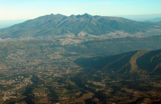
Report on Guagua Pichincha (Ecuador) — January 2001
Bulletin of the Global Volcanism Network, vol. 26, no. 1 (January 2001)
Managing Editor: Richard Wunderman.
Guagua Pichincha (Ecuador) Year 2000 summary; geophysicist takes fatal fall in January 2001
Please cite this report as:
Global Volcanism Program, 2001. Report on Guagua Pichincha (Ecuador) (Wunderman, R., ed.). Bulletin of the Global Volcanism Network, 26:1. Smithsonian Institution. https://doi.org/10.5479/si.GVP.BGVN200101-352020
Guagua Pichincha
Ecuador
0.171°S, 78.598°W; summit elev. 4784 m
All times are local (unless otherwise noted)
Although previous reports discussed events through July 2000 (BGVN 25:06; v. 25, no. 3; v. 24, no. 12), a summary for the entire year has become available and in the interest of evenness of coverage will be reviewed here. A second, brief report is also included, covering events through mid-January. This latter report includes a tragic event that took place on 14 January 2001, the death of the energetic Instituto Geofísico volcano seismologist Diego Viracucha (see Obituary).
Activity during the year 2000 was generally more moderate than during 1999. The dome that started to form on 18 December 1999 ("dome 8") maintained a slow rate of growth until 23 July 2000 when it was disrupted by a series of small explosions. This growth brought about clear and continuous changes in dome morphology, abundant long-period (LP) earthquakes (monthly averages of ~8,700), and numerous seismically detected rock falls (monthly averages of ~3,000). The 23 July 2000 explosions were also accompanied by pyroclastic flows that descended the Cristal river but apparently did not make it to the confluence with the Cinto river as they had in 1999. Moreover, the 23 July 2000 explosions also failed to create a massive ash plume with its attendant disruption to local inhabitants.
After the 23 July explosions, the subsequent extrusions creating the next dome ("dome 9") were accompanied by abnormally high seismicity. For example, there were 20,646 LP earthquakes monthly starting in August 2000. Around this time, signals for rockfalls totaled ~5,400 a month. Starting on 18 December dome 9 grew comparatively slowly with few morphological changes, but was again accompanied by high, though more moderate seismicity (until December 2000 signals included 11,498 LP events and 3,475 rockfalls). In early 2001, the volume of dome 9 stood at 3 x 10⁶ m3, only about 14% smaller than its predecessor, dome 8.
The external flanks deformed after July 2000. Specifically, radial deflation on the E flank (Refugio station) reached 60 µrad. This small-to-moderate deflation was the largest yet seen since the onset of the crisis.
In late 2000 and earliest 2001 with the continuing growth of dome 9, Guagua Pichincha had ~100 earthquakes per day, considerably fewer than in some previous months. Still, in the week of 7-13 January, the volcano's LP earthquakes appeared to have greater magnitudes and source depths because they registered significantly at stations located 10 km out from the crater. Tectonic earthquakes 10 km SW of the crater also registered. Field observers on 14 January attempted to correlate these new, stronger LP earthquakes to visible changes or processes. The observers saw a new crater forming within dome 9, but otherwise, they noted few other surface manifestations that could be linked to the LP earthquakes.
Geological Summary. Guagua Pichincha and the older Pleistocene Rucu Pichincha stratovolcanoes form a broad volcanic massif that rises immediately W of Ecuador's capital city, Quito. A lava dome grew at the head of a 6-km-wide scarp formed during a late-Pleistocene slope failure ~50,000 years ago. Subsequent late-Pleistocene and Holocene eruptions from the central vent consisted of explosive activity with pyroclastic flows accompanied by periodic growth and destruction of the lava dome. Many minor eruptions have been recorded since the mid-1500's; the largest took place in 1660, when ash fell over a 1,000 km radius and accumulated to 30 cm depth in Quito. Pyroclastic flows and surges also occurred, primarily to then W, and affected agricultural activity.
Information Contacts: Instituto Geofísico (IG), Escuela Politécnica Nacional, Apartado 17-01-2759, Quito, Ecuador (URL: http://www.igepn.edu.ec/).

