Report on San Cristobal (Nicaragua) — May 2001

Bulletin of the Global Volcanism Network, vol. 26, no. 5 (May 2001)
Managing Editor: Richard Wunderman.
San Cristobal (Nicaragua) Small gas-and-ash plumes during May and June 2001 cause ashfalls
Please cite this report as:
Global Volcanism Program, 2001. Report on San Cristobal (Nicaragua) (Wunderman, R., ed.). Bulletin of the Global Volcanism Network, 26:5. Smithsonian Institution. https://doi.org/10.5479/si.GVP.BGVN200105-344020
San Cristobal
Nicaragua
12.702°N, 87.004°W; summit elev. 1745 m
All times are local (unless otherwise noted)
Beginning on 11 May 2001 volcanic activity increased above normal levels, with small eruptions producing gas-and-ash clouds that deposited small amounts of ash on a neighboring town. The previous report of anomalous volcanic activity at San Cristóbal was in May 2000 when a series of lahars occurred as a result of the remobilization of ash that had been deposited on the volcano from the 20 November eruption (BGVN 25:02 and 25:05).
On 22 July 2000, ten months prior to the May 2001 eruption, Alain Creusot visited the summit of the volcano. He reported that seismic activity during 18-19 July caused two lakes to empty that were observed during a previous trip. He also found that active fissures inside the crater were partially sealed, which caused the intensity of degassing to decrease.
INETER reported that on 11 May 2001 tremor began to rise at a seismic station on San Cristóbal (figure 9). The tremor reached a maximum level at noon and then slightly diminished, but stayed at relatively high levels for several days. Seismic activity during this period exceeded the maximum level of seismicity throughout the entire December 1999-February 2000 eruption (BGVN 25:02). Beginning on 11 May INETER personnel stationed near the summit of the volcano occasionally observed small plumes of volcanic gas with small amounts of ash emanating from the volcano. In contrast, on 10 May very low levels of gas were emitted from the crater. On 14 May observers noted that gas emissions with small amounts of ash continued. On 17 May the level of seismic activity significantly increased, and pulses of gas and ash rose ~100 m above the crater rim. Small amounts of ash fell in the town of Santa Barbara, 14 km SW of the volcano.
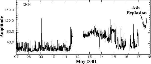 |
Figure 9. Seismic amplitude recorded at CRIN seismic station on San Cristóbal during 7-17 May 2001. Courtesy of INETER. |
INETER noted that rain could mix with ash deposited on the flanks of the volcano and generate dangerous lahars. This occurred after the 1999-early 2000 eruption when rainfall in May 2000 mixed with ash that accumulated on the flanks of the volcano. The lahars were especially strong in the S part of the volcano.
According to news reports, on 21 June an explosion at San Cristóbal sent an ash cloud to a maximum height of 800 m. The cloud extended approximately 25 km downwind of the crater, and ash fell in the town of Chinandega, ~15 km SW of the volcano.
Geological Summary. The San Cristóbal volcanic complex, consisting of five principal volcanic edifices, forms the NW end of the Marrabios Range. The symmetrical 1745-m-high youngest cone, named San Cristóbal (also known as El Viejo), is Nicaragua's highest volcano and is capped by a 500 x 600 m wide crater. El Chonco, with several flank lava domes, is located 4 km W of San Cristóbal; it and the eroded Moyotepe volcano, 4 km NE of San Cristóbal, are of Pleistocene age. Volcán Casita, containing an elongated summit crater, lies immediately east of San Cristóbal and was the site of a catastrophic landslide and lahar in 1998. The Plio-Pleistocene La Pelona caldera is located at the eastern end of the complex. Historical eruptions from San Cristóbal, consisting of small-to-moderate explosive activity, have been reported since the 16th century. Some other 16th-century eruptions attributed to Casita volcano are uncertain and may pertain to other Marrabios Range volcanoes.
Information Contacts: Wilfried Strauch and Virginia Tenorio, Department of Geophysics, Instituto Nicaragüense de Estudios Territoriales (INETER), P.O. Box 1761, Managua, Nicaragua (URL: http://www.ineter.gob.ni/); Alain Creusot, Instituto Nicaraguense de Energía, Managua, Nicaragua (URL: http://www.ine.gob.ni/); La Noticia (URL: http://www.lanoticia.com.ni/); El Nuevo Diario (URL: http://www.elnuevodiario.com.ni/); La Prensa (URL: http://www.laprensa.com.ni/).