Report on Popocatepetl (Mexico) — August 2001

Bulletin of the Global Volcanism Network, vol. 26, no. 8 (August 2001)
Managing Editor: Richard Wunderman.
Popocatepetl (Mexico) Steam-and-ash emissions, periods of dome growth during 2001
Please cite this report as:
Global Volcanism Program, 2001. Report on Popocatepetl (Mexico) (Wunderman, R., ed.). Bulletin of the Global Volcanism Network, 26:8. Smithsonian Institution. https://doi.org/10.5479/si.GVP.BGVN200108-341090
Popocatepetl
Mexico
19.023°N, 98.622°W; summit elev. 5393 m
All times are local (unless otherwise noted)
Following an episode of intense volcanic activity at Popocatépetl during December 2000 and January 2001 (BGVN 25:12) volcanic activity through September 2001 consisted of periods of small-to-moderate emissions of steam, gas, and ash, several ash cloud-producing eruptions, periods of many high-frequency volcanic earthquakes, and fumarolic activity. In addition, a new lava dome grew within the crater left after a lava dome was destroyed in December 2000.
The Centro Nacionale de Prevencion de Desastres (CENAPRED) and the Washington Volcanic Ash Advisory Center (VAAC) noted several small-to-moderate sized eruptions during the report period. Large eruptions are discussed below, and others are in table 14.
Table 14. Eruptions at Popocatépetl during February-August 2001 not discussed in the report, based on information from CENAPRED, Washington VAAC, and the México City Meteorological Watch Office via the Washington VAAC. All heights are approximate values above the volcano.
| Date | Time | Description of activity |
| 01 Feb 2001 | 1345 | Narrow ash plume visible in GOES-8 imagery rose to ~1 km, drifted NNE |
| 08 Feb 2001 | 1921 | Small ash cloud rose to 2 km, drifted NE |
| 09 Feb 2001 | 1400 | Ash cloud rose to 2 km |
| 11 Feb 2001 | 1338 | Ash cloud rose to 2.5 km, drifted S |
| 11 Feb 2001 | 1348 | Ash cloud rose to 2.5 km, drifted S |
| 06 May 2001 | 1205 | Steam-and-ash cloud rose to 1.5 km |
| 14 May 2001 | 0939 | Steam-and-ash cloud rose to 1.5 km |
| 26 May 2001 | 1122 | Steam-and-ash emission rose to 1.5 km |
| 01 Jun 2001 | 0804 | Steam-and-ash cloud rose to 1.5 km |
| 09 Jun 2001 | 0424 | Small explosion, most intense phase lasted 30 seconds |
| 11 Jun 2001 | 1100 | Ash cloud rose to 2 km, drifted W |
| 12 Jun 2001 | 1648 | Eruption occurred with the most intense phase lasting 30 seconds, too cloudy to observe ash cloud |
| 24 Jun 2001 | 0900 | Small ash cloud rose to 0.5 km, drifted SW |
| 01 Jul 2001 | 0912 | Ash cloud rose to 800 m, drifted SSW |
| 14 Jul 2001 | 1045 | Steam-and-ash cloud rose to 2 km, drifted W |
| 14 Jul 2001 | 2303 | Eruption occurred, but too cloudy to assign a height to the ash cloud |
| 14 Jul 2001 | 2341 | Ash cloud rose to 0.5 km, drifted NW |
| 24 Jul 2001 | 0900 | Summit-level emission, drifted W |
| 09 Aug 2001 | 2300 | Ash cloud rose to 2 km |
| 17 Aug 2001 | 1514 | Ash cloud rose to 2 km |
Volcanic Activity during late January-February 2001. As of late January Popocatépetl was at Alert Level Yellow Phase Three, with a 12-km-radius restricted area. During the end of January through February several moderate-to-small eruptions occurred at Popocatépetl. On 30 January during 1530-1545 a moderate ash emission was visible on CENAPRED's video camera rising to ~1.5 km above the volcano's summit. The ~9-km-wide moderately-dense ash cloud extended from the summit to the N and NE. An eruption on 15 February at 1542 produced an ash cloud that rose to 2.5 km above the summit and drifted to the ENE. The intense phase of the eruption lasted about 15 minutes. The ash cloud was tracked using Geostationary Operational Environmental Satellite-8 (GOES-8) imagery as it drifted to the Gulf of México by 0102 the next day. The NOAA Operational Significant Event Imagery Support Team created a movie loop using images captured by GOES-8 that are available at http://www.osei.noaa.gov/.
New lava dome growth and destruction during March and April. Relatively low volcanic activity during the beginning of March consisted of small steam-and-ash emissions and periods of harmonic tremor. CENAPRED reported that beginning on 12 March volcanic activity rose to high levels, with harmonic tremor occurring for a cumulative hour and approximately 50 small emissions of steam, gas, and occasionally ash. An eruption at 2023 produced an ash column that rose 1 km above the summit and incandescent volcanic fragments were hurled up to 1 km away from the crater to the volcano's N flank.
On 13 March at 1953 another eruption produced an ash column that rose to 2 km. While flying over the volcano the same day CENAPRED personnel observed a new 100- to 150-m-diameter lava dome growing in the inner crater that was created after the December 2000 dome was destroyed. On both 14 and 15 March a cumulative hour-long period of harmonic tremor occurred and 55, and 73 emissions of steam, gas, and ash occurred, respectively. The lava dome was 200 m in diameter and about 40 m tall as of 15 March. On 16 March there was a larger number of volcanic emissions (95) than on the previous couple of days, but less harmonic tremor was registered (0.5 hour). Volcanic activity began to decrease on 17 March, with 38 emissions occurring and 15 minutes of harmonic tremor recorded.
During the remainder of March and early April volcanic activity related to the emplacement of the new lava dome occurred; there were episodes of harmonic tremor totaling up to 8 hours per day, a large amount of high-frequency tremor, an average of two tectono-volcanic earthquakes per day up to M 2.3, and fumarolic activity.
On 16 April at 1948 a moderate eruption produced an ash cloud that rose to 4 km above the volcano's summit and drifted to the SW (figure 37, a and b). The eruption also sent incandescent volcanic fragments up to 2 km from the crater to the volcano's NE and NW flanks. The 40-second-long eruption destroyed the lava dome that had formed within the crater over the course of the previous several weeks. After the eruption the level of volcanic activity stabilized, with a relatively low number of gas, steam, and ash emissions and episodes of harmonic tremor. On 17 April a small lahar traveled down the Achupashal Gorge.
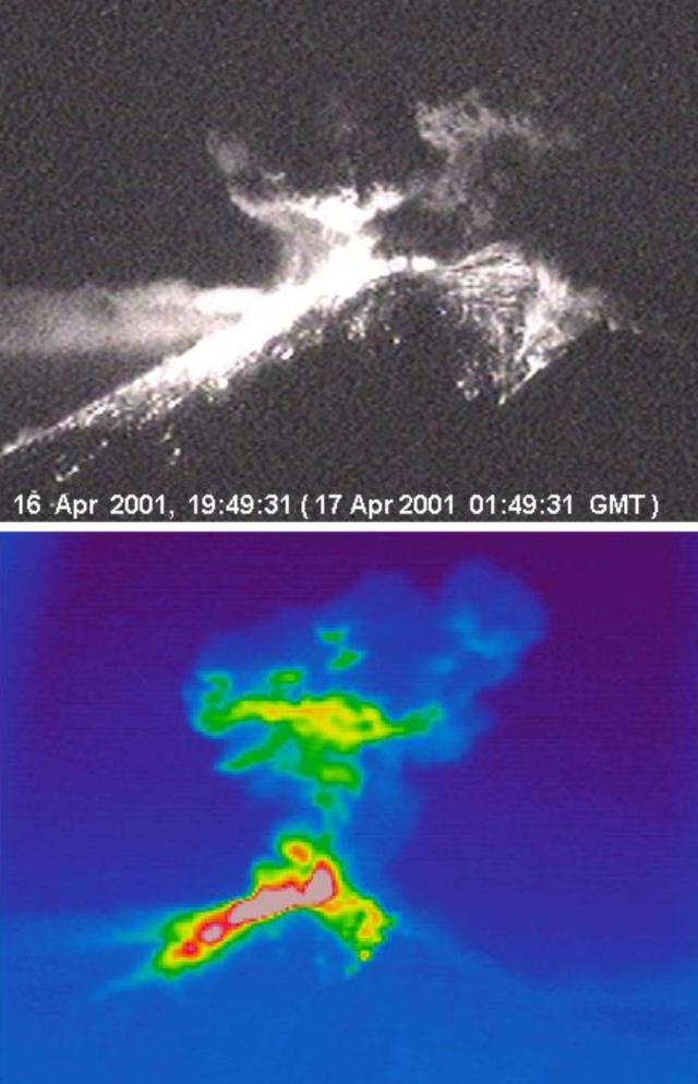 |
Figure 37. For Popocatépetl, (a) a photograph showing the 16 April 2001eruption at 1949, and (b) thermal image of the 16 April eruption at an unstated time. In the thermal image, the ash cloud is visible rising to 4 km above the volcano's summit. Higher temperatures are represented by red and pink color shades in the area of fresh tephra deposition. The N flank of the volcano is shown. Hot material is visible on the upper NE and NW flanks of the volcano. Courtesy of CENAPRED. |
Volcanic activity during late April-July. Following episodes of harmonic tremor during 28 April through early on 29 April a moderate eruption at 0819 produced an ash cloud that CENAPRED reported rose 2 km above the summit and quickly drifted to the ESE. A pilot reported that the ash cloud reached up to 3.5 km. The most intense phase of the eruption lasted approximately 1 minute. Extreme cloudiness obstructed clear views of the volcano, but scientist believe incandescent volcanic fragments were ejected during the eruption. Noise from the eruption was heard in San Pedro Benito Juárez (Puebla), 10 km SE of the volcano. By 0930 small amounts of ash fell in San Pedro Benito Juárez. Another small eruption occurred at 1310 and produced an ash cloud that rose 1.5-2 km above the volcano. After the eruptions volcanic activity returned to previous levels, with episodes of harmonic tremor and small volcanic emissions.
One of the many small eruptions during May occurred on the 13th at 2301 and ejected volcanic fragments up to 0.5 km away from the volcano's crater. Cloudy conditions prohibited observation of a possible accompanying ash cloud. The eruption was followed by an episode of harmonic tremor. A moderate-sized eruption on 31 May at 2136 sent incandescent material 2-3 km from the crater down the NE flank. The ash cloud produced from the eruption rose ~2 km above the volcano's summit and drifted to the W. The most intense phase of the eruption lasted approximately 1 minute. Harmonic tremor started about 90 seconds after the eruption began, and lasted about 5 hours. The following day a similar, but smaller, eruption at 0804 sent a steam-and-ash cloud to ~1.5 km.
Volcanic activity was relatively low in June, with small steam-and-ash emissions (table 4). CENAPRED reported that a moderate-sized eruption occurred on 3 July at 0410, which may have ejected incandescent volcanic fragments around the rim of the summit crater. Later that day, at 0648, a larger eruption produced an ash cloud that rose more than 4 km above the summit in a few minutes (figure 38). According to the Washington VAAC, at least three ash-producing eruptions occurred on 3 July; at 0425, 0648, and 0830. They reported that the 0425 eruption produced an ash cloud that was visible on GOES-8 imagery spreading in two directions at different heights; less than 1 km above the volcano one portion of the ash cloud drifted to the NW, and ~1-4 km above the summit it drifted to the SE (figure 39). Small amounts of ash fell NW of the volcano in the towns of San Pedro Nexapa, Amecameca, Tlalmanalco, San Rafael, Iztapaluc, and as far away as 35 km in Chalco.
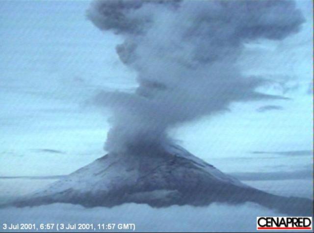 |
Figure 38. Photograph of an eruption of Popocatépetl taken on 3 July 2001 at 0657. The northern side of the volcano is shown. Courtesy of CENAPRED. |
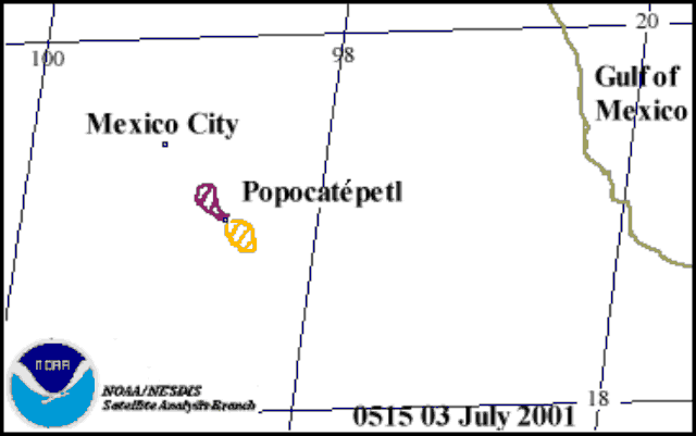 |
Figure 39. Sketch showing the distributions of two portions of a Popocatépetl ash cloud in GOES-8 imagery on 3 July 2001at 0515. The enclosed hatched areas depict the location of volcanic ash. The portion of the ash cloud that drifted to the NW was ~ 1 km above the volcano and the portion that drifted to the SE, ~ 1-4 km above the volcano. Courtesy of Washington VAAC. |
Based on information from pilot reports and ground observations, the Washington VAAC reported that the ash cloud was 9.3 km SE of México City airport (~65 km NE of the volcano) at 0930. Very light ash fell on runways at the Mexico City Airport, causing some airlines to briefly suspend takeoffs. CENAPRED's seismic data revealed that the explosive event lasted ~10 minutes, after which volcanism returned to low levels.
On 23 July CENAPRED reduced the Alert Level from Yellow Phase Three to Phase Two because volcanism was lower than it had been in December 2000 when the Alert Level was originally raised (BGVN 25:12). Under the new Alert Level, activity continued to be prohibited within a 12 km radius around the volcano, but controlled travel was permitted on the road between Santiago Xalitzintla (Puebla) ~10 km NE of the volcano and San Pedro Nexapa (State of México) ~12 km NW of the volcano, including Paso de Cortés.
New dome growth episode during August. A new episode of dome growth was first detected at Popocatépetl on 9 August when a significant increase in seismicity at the volcano lasted for about 24 hours. The seismicity was much lower than that detected in the interval beginning on 13 December 2000, a time when the highest amplitude tremor was recorded at Popocatépetl to date. A high-altitude flight took place on 10 August (sponsored by the Secretary of Communication and Transportation); it revealed that a new dome had been emplaced. It emerged at the bottom of the inner crater that formed after the December 2000 dome was destroyed (figures 40 and 41).
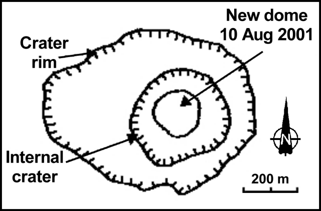 |
Figure 40. Sketch of Popocatépetl's summit crater and the new lava dome as they appeared on 10 August 2001. Courtesy of CENAPRED and Instituto de Geofísica, UNAM. |
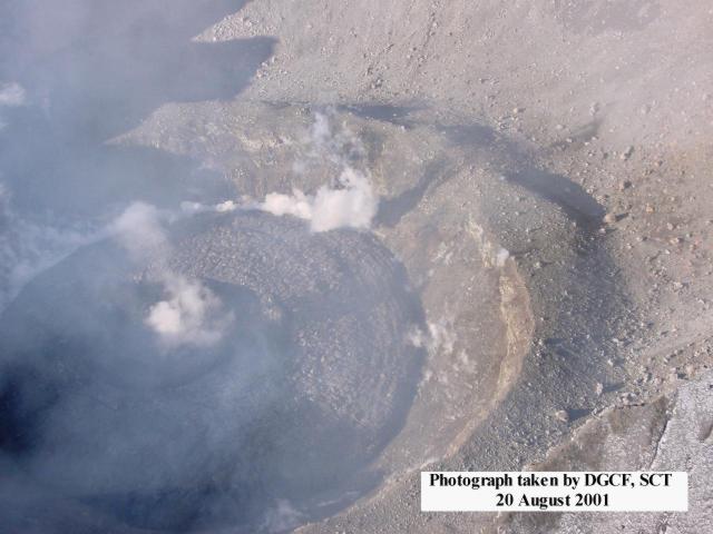 |
Figure 41. Photograph of Popocatépetl's new lava dome taken on 20 August 2001. Courtesy of CENAPRED and the Secretary of Communication and Transportation. |
The lava dome's volume was estimated to be slightly more than 0.5 million cubic meters. Based on the assumption that the period of dome growth coincided with the period of maximum seismicity, the rate of growth was estimated to be 7-8 m3/s; less than 5% of the rates measured in December 2000. On 13 August the dome was 190 m in diameter and 30 m tall, about 5% the size of the December 2000 dome.
On 15 August at 1545 a new episode of high seismic activity began at the volcano. This episode was similar to the 9 August episode, but more steam-and-ash emissions with higher intensities occurred on 15 August. Seismicity further increased at 1800. The entire episode was attributed to a higher rate of lava extrusion. The waveforms and amplitudes of seismic signals were similar to those recorded on 13 December 2000; however, the total seismic energy release was about 30 % of the energy released on 13 December.
Small amounts of ash from the emissions fell NW and W of the volcano in San Pedro Nexapa, Amecameca, Ozumba, Atlautla, and San Juan Tehuiztitlán. Volcanic activity decreased on 16 August around 0115. During the night incandescence was seen at the summit and at 0538 incandescent fragments were ejected more than 500 m down the volcano's N flank.
After the August 15 increase in seismicity, seismic and volcanic activity returned to normal levels, with small volcanic emissions and periods of high-frequency and low-amplitude tremor. On 9 September during 0815-1605 an episode of frequent small- to moderate-sized eruptions began at Popocatépetl. The eruptions produced steam-and-ash emissions that rose to a maximum height of 1 km above the dome and drifted to the NW. During the night a small eruption sent incandescent fragments up to 200 m from the crater. Small amounts of ash fell in Ozumba (~15 km W of the volcano) and in Yecapixtla (~25 km SW of the volcano). Aerial photographs taken on 20 September revealed that the lava dome was visible within the crater.
Geological Summary. Volcán Popocatépetl, whose name is the Aztec word for smoking mountain, rises 70 km SE of Mexico City to form North America's 2nd-highest volcano. The glacier-clad stratovolcano contains a steep-walled, 400 x 600 m wide crater. The generally symmetrical volcano is modified by the sharp-peaked Ventorrillo on the NW, a remnant of an earlier volcano. At least three previous major cones were destroyed by gravitational failure during the Pleistocene, producing massive debris-avalanche deposits covering broad areas to the south. The modern volcano was constructed south of the late-Pleistocene to Holocene El Fraile cone. Three major Plinian eruptions, the most recent of which took place about 800 CE, have occurred since the mid-Holocene, accompanied by pyroclastic flows and voluminous lahars that swept basins below the volcano. Frequent historical eruptions, first recorded in Aztec codices, have occurred since Pre-Columbian time.
Information Contacts: Carlos Valdés González, Roberto Quass Weppen, Gilberto Castelan, Enrique Guevara Ortiz, and Angel Gómez-Vázquez, Centro Nacional de Prevención de Desastres (CENAPRED), Av. Delfín Madrigal No.665. Coyoacan, México. D.F. 04360 (URL: https://www.gob.mx/cenapred/); Servando de la Cruz-Reyna, Instituto de Geofísica, UNAM. Cd. Universitaria. Circuito Institutos. Coyoácan. México, D.F. 04510 (URL: http://www.geofisica.unam.mx/); Washington VAAC, Satellite Analysis Branch (SAB), NOAA/NESDIS E/SP23, NOAA Science Center Room 401, 5200 Auth Road, Camp Springs, MD 20746, USA (URL: http://www.ssd.noaa.gov/); NOAA Operational Significant Events Imagery Support Team (OSEI), NOAA/NESDIS, World Weather Building, Room 510, 5200 Auth Road, Camp Springs, MD 20748 USA (URL: https://www.nnvl.noaa.gov/); Secretaría de Comunicaciones y Transportes, Xola Y Avenida Universidad, Cuerpo "C",Piso 1, Col. Navarte, Del. Benito Juarez, C. P. 03028, México (URL: http://www.sct.gob.mx/); Associated Press.