Report on El Chichon (Mexico) — October 2001
Bulletin of the Global Volcanism Network, vol. 26, no. 10 (October 2001)
Managing Editor: Richard Wunderman.
El Chichon (Mexico) Crater lake water level lower in September 2001 despite increased rainfall
Please cite this report as:
Global Volcanism Program, 2001. Report on El Chichon (Mexico) (Wunderman, R., ed.). Bulletin of the Global Volcanism Network, 26:10. Smithsonian Institution. https://doi.org/10.5479/si.GVP.BGVN200110-341120
El Chichon
Mexico
17.3602°N, 93.2297°W; summit elev. 1150 m
All times are local (unless otherwise noted)
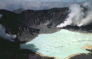
King Freeland, a Villahermosa resident since 1981, has been taking photographs of El Chichón since 1985 and going into the inner crater yearly (figure 4). In September 2001 he reported that visible fumarolic activity in the crater had dropped during the previous six months and had changed to a new area of the crater. The level of the lake, normally dependent on rainfall, had lowered in the previous three months despite an increase in precipitation. Some of the streams on the outer flanks of the volcano had dried up for the first time in 15 years, and bubble activity was observed in the entire lake. In 1987, Freeland and others went swimming in the crater lake. In September he reported that the water was too hot to touch.
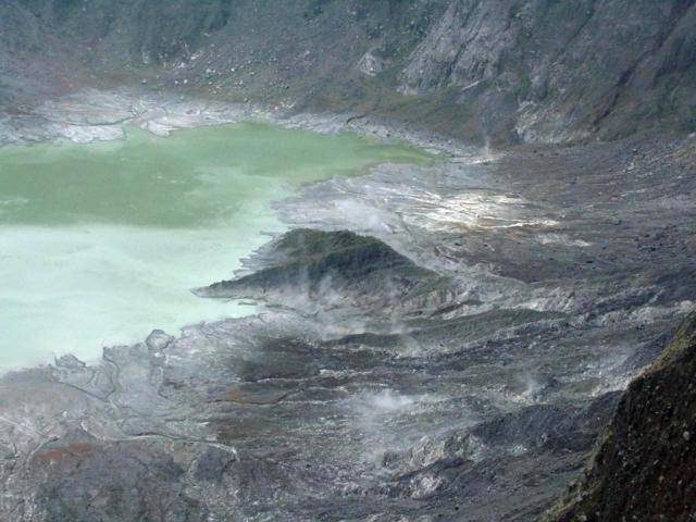 |
Figure 4. Photo of the NE end of the ~ 900-m-wide crater of El Chichón, showing the drop in the water level that has occurred during July-September 2001. The photo was taken from the E wall of the crater facing NNW. The lake, lengthwise, is 1/2-1/3 the diameter of the crater. Courtesy of King Freeland. |
A recent article (Duffield, 2001) describes an oral tradition of the Chamula Indians, descendants of the Mayan culture. A story passed down through several generations tells of frequent earthquakes, a drying river, and a sudden flood of boiling water that nearly wiped out the ancient culture. Duffield relates the story to his studies of the 1982 eruption at El Chichón, during which many of the conditions of the eruption, including frequent earthquakes and several deaths by surges of very hot water, seem to correspond to the ancient oral tradition. Duffield noted that such oral traditions, although not scientifically provable, can provide valuable insight into events that have occurred in the past, and clues to those events that may occur in the future.
Reference. Duffield, Wendell A., 2001, At least Noah had some warning: Eos, Transactions of the American Geophysical Union 82, p.305, 309.
Geological Summary. El Chichón is a small trachyandesitic tuff cone and lava dome complex in an isolated part of the Chiapas region in SE México. Prior to 1982, this relatively unknown volcano was heavily forested and of no greater height than adjacent non-volcanic peaks. The largest dome, the former summit of the volcano, was constructed within a 1.6 x 2 km summit crater created about 220,000 years ago. Two other large craters are located on the SW and SE flanks; a lava dome fills the SW crater, and an older dome is located on the NW flank. More than ten large explosive eruptions have occurred since the mid-Holocene. The powerful 1982 explosive eruptions of high-sulfur, anhydrite-bearing magma destroyed the summit lava dome and were accompanied by pyroclastic flows and surges that devastated an area extending about 8 km around the volcano. The eruptions created a new 1-km-wide, 300-m-deep crater that now contains an acidic crater lake.
Information Contacts: King Freeland, Core Laboratories, Cerrada Av. Universidad 102, Col. Pino Suarez, C.P. 86020 Villahermosa, Tabasco, Mexico; Wendell A. Duffield, USGS, Flagstaff, Arizona, USA.