Report on Irazu (Costa Rica) — October 2001
Bulletin of the Global Volcanism Network, vol. 26, no. 10 (October 2001)
Managing Editor: Richard Wunderman.
Irazu (Costa Rica) Small-magnitude seismic events; crater lake level generally constant
Please cite this report as:
Global Volcanism Program, 2001. Report on Irazu (Costa Rica) (Wunderman, R., ed.). Bulletin of the Global Volcanism Network, 26:10. Smithsonian Institution. https://doi.org/10.5479/si.GVP.BGVN200110-345060
Irazu
Costa Rica
9.979°N, 83.852°W; summit elev. 3436 m
All times are local (unless otherwise noted)
Our last report (BGVN 25:06) covered activity at Irazú through June 2000, which included feeble microseismicity and small fluctuations in the water level of the crater lake. Similar activity occurred during August 2000 through at least September 2001.
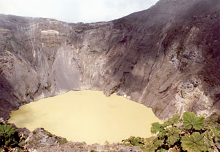
The level of the crater lake generally stayed the same, covering the entire bottom of the crater. The IRZ2 seismograph continued to register varying numbers of small seismic events: 33 in August 2000, 21 in September 2000, 16 in March 2001, 10 in May 2001, 108 in June 2001, and 68 in July 2001 (data from other months not available).
The lake was green, with bubbling occurring mostly at the N end of the crater, and also in the NW and NE. Bubbling was reported at the S end of the crater during August 2001. The N and W wall continued sliding toward the lake. Fumarolic activity continued at the NW flank.
Geological Summary. The massive Irazú volcano in Costa Rica, immediately E of the capital city of San José, covers an area of 500 km2 and is vegetated to within a few hundred meters of its broad summit crater complex. At least 10 satellitic cones are located on its S flank. No lava effusion is known since the eruption of the Cervantes lava flows from S-flank vents about 14,000 years ago, and all known Holocene eruptions have been explosive. The focus of eruptions at the summit crater complex has migrated to the W towards the main crater, which contains a small lake. The first well-documented eruption occurred in 1723, and frequent explosive eruptions have occurred since. Ashfall from the last major eruption during 1963-65 caused significant disruption to San José and surrounding areas. Phreatic activity reported in 1994 may have been a landslide event from the fumarolic area on the NW summit (Fallas et al., 2018).
Information Contacts: Observatorio Vulcanológico y Sismológico de Costa Rica, Universidad Nacional (OVSICORI-UNA), Apartado 86-3000, Heredia, Costa Rica.

