Report on Tofua (Tonga) — December 2001
Bulletin of the Global Volcanism Network, vol. 26, no. 12 (December 2001)
Managing Editor: Richard Wunderman.
Tofua (Tonga) Typical fumarolic emissions continue; geologic mapping of cinder-cone complexes
Please cite this report as:
Global Volcanism Program, 2001. Report on Tofua (Tonga) (Wunderman, R., ed.). Bulletin of the Global Volcanism Network, 26:12. Smithsonian Institution. https://doi.org/10.5479/si.GVP.BGVN200112-243060
Tofua
Tonga
19.75°S, 175.07°W; summit elev. 515 m
All times are local (unless otherwise noted)
On 1 August 2000, Jeff and Raine Williams, aboard the sailing yacht Gryphon, reported that they spent a couple nights at Uanukuhahaki island, approximately 48 km E of the volcanic islands of Kao and Tofua. They noted that "steam can be seen rising from Tofua almost continuously." They also observed that pumice stones were scattered all along the beach at Uanukuhahaki.
Tim Worthington (Christian-Albrechts-Universität zu Kiel) notes that the activity seen on 1 August 2000 is the normal state of Tofua. In September 1999, Worthington mapped a thick compound ash layer (with three distinct units) containing abundant pumice clasts that is widespread on Kotu, Ha'afeva, Matuku, and other islands in the group 30-50 km E of Tofua and Kao. The ash represents the distal part of the pyroclastic flow sequence associated with a pre-historic caldera-forming eruption on Tofua. Other workers, including Shane Cronin (GEOMAR), are looking at these units in more detail with a view to dating the eruption. The "pumice stones" seen on Uanukuhahaki may be blocks of andesitic pumice eroded from this ash sequence.
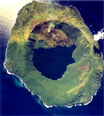
Geologic mapping and observations, November 2000. Worthington was part of a group that spent 8 days mapping and sampling at Tofua in late November 2000. Tofua is a nearly circular island 9.5 x 7.1 km in diameter. The flanks rise steeply to a well-defined caldera rim reaching 515 m elevation in the NW and SE. The inner caldera walls are precipitous, and the caldera is occupied by a large, cold, fresh-water lake standing at 30 m elevation. The most recent volcanism took place from vents within the N half of the caldera, where there are three cinder-cone complexes.
The westernmost cinder-cone complex is densely forested and rather degraded. The easternmost complex consists of four distinct but intergrown small cinder cones with well-formed craters (two have sub-craters). A series of young rubble-topped basaltic andesite lavas were erupted from these cones and flowed towards (and into) the lake. Different degrees of vegetation on each flow suggest a recurrence interval of about 50 years, and the youngest may have been emplaced during the 1958-60 eruptions. It was mapped by visiting geologists in the early 1970s.
The northernmost cinder cone is the large and vigorously degassing Lofia, with a basal diameter of ~500 m and a summit at 380 m elevation. Lofia has a summit crater 70 m in diameter with vertical inner walls, which was completely filled by dense brownish-blue SO2-rich steam during the visit. Intermittent chugging sounds resembling a train starting to move could be heard from the crater rim. From the yacht, occasional dull orange reflections were observed in clouds above the caldera rim on two nights. However, there was no evidence of recent spatter around the crater rim, nor any indication of significant volcanic activity since the 1958-60 eruptions.
On calm days the plume from Lofia rose above the caldera rim and was visible from nearby islands and to passing ships; more commonly it dispersed in the wind before passing the caldera rim. Numerous breadcrust bombs were plastered onto the NW caldera wall downwind from Lofia, and had welded to form a sparsely vegetated 20-m-thick rootless lava flow on the NW caldera rim. The region of sparse vegetation on the outer NW caldera wall extended from 300 to 515 m elevation, gaving the NW summit of Tofua a "burnt" appearance to passing ships. The spatter testifies to vigorous fire-fountaining at Lofia, whose summit is 130 m below and 700 m S of the caldera rim. The latest episode of this activity may have taken place during the 1958-60 eruptions, but the spatter almost certainly represents the accumulated result of many such episodes.
Geological Summary. The low, forested Tofua Island in the central part of the Tonga Islands group is the emergent summit of a large stratovolcano that was seen in eruption by Captain Cook in 1774. The summit contains a 5-km-wide caldera whose walls drop steeply about 500 m. Three post-caldera cones were constructed at the northern end of a cold fresh-water caldera lake, whose surface lies only 30 m above sea level. The easternmost cone has three craters and produced young basaltic andesite lava flows, some of which traveled into the caldera lake. The largest and northernmost of the cones, Lofia, has a steep-sided crater that is 70 m wide and 120 m deep and has been the source of historical eruptions, first reported in the 18th century. The fumarolically active crater of Lofia has a flat floor formed by a ponded lava flow.
Information Contacts: Tim J. Worthington, Institut für Geowissenschaften, Christian-Albrechts-Universität zu Kiel, Olshausenstr. 40, D-24118 Kiel, Germany; Jeff and Raine Williams, P.O. Box 729, Funkstown, MD 21734, USA.