Report on Popocatepetl (Mexico) — February 2002

Bulletin of the Global Volcanism Network, vol. 27, no. 2 (February 2002)
Managing Editor: Richard Wunderman.
Popocatepetl (Mexico) Eruptions through February 2002 send ash clouds to ~ 5.5 km above the summit
Please cite this report as:
Global Volcanism Program, 2002. Report on Popocatepetl (Mexico) (Wunderman, R., ed.). Bulletin of the Global Volcanism Network, 27:2. Smithsonian Institution. https://doi.org/10.5479/si.GVP.BGVN200202-341090
Popocatepetl
Mexico
19.023°N, 98.622°W; summit elev. 5393 m
All times are local (unless otherwise noted)
During October 2001 through at least February 2002, volcanic activity at Popocatépetl consisted of small-to-moderate eruptions of steam, gas, and generally minor amounts of ash, along with episodes of harmonic tremor. Ash clouds rose up to ~6 km above the summit. The number of emissions ranged from 8 per week to 154 per day on 11 December. Because of the remote location and high elevation of the summit, the dome growth within the crater was often hard to constrain, although seismicity, remote sensing, and occasional flights over the summit did shed light on the situation. The following report is compiled from updates from the Centro Nacional de Prevencion de Desastres (CENAPRED) and from reports issued by the Washington Volcanic Ash Advisory Center (VAAC).
On 25 October an ash plume reached ~1.3 km above the summit and extended ~20-30 km N. An aerial photograph of the crater taken on 25 October showed that the lava dome, which had been reported on 20 September 2001, had subsided. In addition, a new 50-m-diameter lava dome had grown in the bottom of the internal crater. CENAPRED stated that the presence of the lava dome indicated the possibility of small explosions occurring within the following days to weeks. A similar situation was observed in April 2001.
On 10 November at 0324 a small explosion produced an ash column ~1 km high that drifted E. CENAPRED's volcano cam showed incandescent fragments being hurled up to 300 m to the E. During mid-November, seismometers recorded episodes with increased emissions and periods of harmonic tremor, activity that may be associated with lava dome growth. Similar events were observed on 15 August and 10 September.
During a flight over the volcano on 21 November a new 130-m-diameter lava dome was seen growing inside the internal crater (figure 42). The growth of this lava dome corresponded with increased emissions and seismicity on 17 and 18 November. Activity increased slightly on 25 November; three volcano-tectonic earthquakes occurred with magnitudes of 2.3, 2.4, and 2.7.
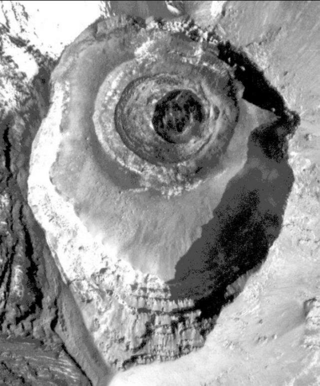 |
Figure 42. A sub-vertical aerial photo of Popocatepetl's concentric summit craters taken on 21 November 2001. The new (21 November 2001) dome lies within the innermost crater; it is 130 m in diameter, circular, and generally dark in color; much of the rest of the summit is gray to white due to varying degrees of ash on top of snow and ice. N is towards the top; the high point on the crater rim is at the bottom. Courtesy CENAPRED. |
On 6 December at 0615, two M-2.3 volcano-tectonic earthquakes occurred, located 3 km and 5 km below the crater. Fumarolic activity remained low.
A flight on 10 December confirmed the growth of a new dome, with an estimated diameter of 190 m. During 1830 to about 2200, several small-to-moderate emissions ejected incandescent fragments up to ~1 km away. This increase in activity was taken to herald the destruction of the 21 November dome. At 1958, ash was visible over the volcano on satellite imagery, and at 0732 on 11 December a bright hotspot was visible in shortwave imagery.
On 17 December at 2212 a small explosion ejected incandescent fragments up to 500 m to the E and produced an ~1-km ash column that drifted E. An ~2-hour episode of low-amplitude harmonic tremor accompanied the event.
Several moderate short explosions produced ash-and-gas columns on 18 December. An explosion at 1124 sent incandescent fragments 1 km to the ENE flank and produced an ash column to ~2.5 km above the summit that drifted NNE. Episodes of low-amplitude harmonic tremor accompanied the activity. At 1215 an ~18-m-wide plume was visible on satellite imagery reaching ~2.4 km above the summit and extending 50 km from the volcano.
A short episode of low-amplitude harmonic tremor on 19 December was followed by an explosion at 1926 that sent incandescent fragments 2 km to the E and NE. An associated seismic event lasted ~3 minutes, with a more intense phase occurring for 2 minutes, after which the seismicity returned to stable levels. Another low-amplitude harmonic tremor episode occurred the following day.
On 22 December at 1735 an explosion emitted an ash column to 2.5 km that drifted NE. The event was accompanied by an episode of low-amplitude tremor that lasted for 4 hours. Following the event an ash cloud was visible on satellite imagery reaching up to ~5.6 km above the summit. The ash cloud was centered 54 km ESE of the summit and was up to 15 km wide. One light ash fall was registered in some parts of the city of Puebla, ~60 km E of the volcano. Following the 22 December explosion, activity decreased to a low level, but episodes of low-amplitude harmonic tremor continued.
On 7 January an M 2.6 volcano-tectonic earthquake was located 3.3 km below the summit to its SE. Emissions produced small amounts of ash that rose to 800 m, and a gas plume rose 500 m and moved SE. CENAPRED suggested the plume was related to the cooling of the December 2001 lava dome. A photograph taken on 11 January showed that this dome had become partially destroyed. On 11 and 13 January, emissions sent plumes to ~2.0 km above the summit. The 11 January plume was 3 km wide and was visible on satellite imagery extending 14 km from the volcano.
At 0517 on 23 January a moderate eruption was accompanied by continuous tremor. During the eruption incandescent volcanic fragments were ejected short distances from the crater, and a steam-and-ash cloud was produced. According to pilot reports, the cloud rose to ~3.6 km above the summit. Satellite imagery showed the cloud drifting to the NE (figure 43), and by 1845 on 23 January it was visible in the vicinity of the city of Poza Rica, ~250 km to the NE. The cloud continued drifting NE over the Gulf of Mexico until it was no longer visible on satellite imagery. Small amounts of ash fell at Paso de Cortés (~7.5 km N of the summit) and the town of Tlaxcala (50 km NE).
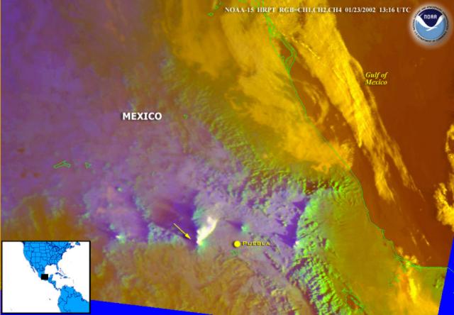 |
Figure 43. Satellite imagery related to an eruption at Popocatépetl on 23 January 2002 (capturing the scene at 1316 UTC). The image shows a distinct white ash plume extending NE ~ 40 km from the volcano. Arrow points approximately towards the summit (the source of the plume); distance from the summit to Puebla is ~ 60 km; N is up. Courtesy NOAA. |
The 23 January eruption marked the formation of a new lava dome, which was seen on an aerial photograph taken on 24 January. At that point it was 180 m in diameter and 150 m high. Thus, its volume measured ~20 times smaller than the dome formed in December 2000 (BGVN 25:12). On 28 January, seven volcano-tectonic earthquakes occurred with magnitudes of 1.8 to 2.3. A small steam plume drifted NW.
After several weeks of low-level activity, seismicity increased slightly at Popocatépetl during 15-16 February 2002. Harmonic tremor and low-magnitude volcano-tectonic earthquakes were recorded. CENAPRED stated that the activity was possibly related to the ascent of magma and to the formation of yet another new dome.
On 23 February at 2156 a minor explosion ejected incandescent fragments up to 200 m before they fell back into the crater, and a low-volume ash plume reached 700 m above the summit. The next day, short isolated harmonic tremor episodes accompanied several small emissions that produced gas plumes. An episode of low-amplitude harmonic tremor on 28 February lasted for ~6 hours.
Heightened activity, including tremor, continued through at least 28 February. CENAPRED suggested that this activity could be related to growth of another small dome after the destruction of the 21 November dome, but that remained unverified. CENAPRED reported that the activity during the end of February was similar to that during August, September, November, and December 2001, and during January 2002. The volcano was last reported at Alert Level Yellow Phase II during mid-February.
Geological Summary. Volcán Popocatépetl, whose name is the Aztec word for smoking mountain, rises 70 km SE of Mexico City to form North America's 2nd-highest volcano. The glacier-clad stratovolcano contains a steep-walled, 400 x 600 m wide crater. The generally symmetrical volcano is modified by the sharp-peaked Ventorrillo on the NW, a remnant of an earlier volcano. At least three previous major cones were destroyed by gravitational failure during the Pleistocene, producing massive debris-avalanche deposits covering broad areas to the south. The modern volcano was constructed south of the late-Pleistocene to Holocene El Fraile cone. Three major Plinian eruptions, the most recent of which took place about 800 CE, have occurred since the mid-Holocene, accompanied by pyroclastic flows and voluminous lahars that swept basins below the volcano. Frequent historical eruptions, first recorded in Aztec codices, have occurred since Pre-Columbian time.
Information Contacts: Centro Nacional de Prevencion de Desastres (CENAPRED), Delfin Madrigal 665, Col. Pedregal de Santo Domingo, Coyoacán, 04360, México D.F. (URL: http://www.cenapred. unam.mx/); Washington Volcanic Ash Advisory Center (VAAC), Satellite Analysis Branch (SAB), NOAA/NESDIS E/SP23, NOAA Science Center Room 401, 5200 Auth Road, Camp Springs, MD 20746, USA (URL: http://www.ssd.noaa.gov/).