Report on San Cristobal (Nicaragua) — April 2002

Bulletin of the Global Volcanism Network, vol. 27, no. 4 (April 2002)
Managing Editor: Richard Wunderman.
San Cristobal (Nicaragua) November ash-and-gas emissions; thousands of earthquakes through May 2002
Please cite this report as:
Global Volcanism Program, 2002. Report on San Cristobal (Nicaragua) (Wunderman, R., ed.). Bulletin of the Global Volcanism Network, 27:4. Smithsonian Institution. https://doi.org/10.5479/si.GVP.BGVN200204-344020
San Cristobal
Nicaragua
12.702°N, 87.004°W; summit elev. 1745 m
All times are local (unless otherwise noted)
Instituto Nicaragüense de Estudios Territoriales (INETER) reported that during December 2001 through May 2002 San Cristóbal maintained generally constant levels of seismicity and moderate tremor levels. Thousands of earthquakes per month were recorded, most with frequencies of 4.0 to over 10 Hz. Very few events registered with frequencies less than 1.0 Hz.
The third eruptive stage in 2001 was during 7-25 November, when strong ash-and-gas emissions and rumblings occurred and small amounts of ash fell in surrounding areas. After visiting the crater on 11 and 25 November, and 9 December, Vicente Perez (INETER) reported rockfalls and strong emissions of gas and ash. Fumarolic temperatures on 25 November were ~40-100°C, and were similar during December. On 15 January Pedro Perez observed only sporadic gas emanations during a crater visit.
During November through 23 February seismic tremor generally remained between 20 and 60 RSAM units, with the maximum tremor occurring during 8-14 November, when ash-and-gas emissions were strongest. Tremor frequency was 4.0-6.0 Hz.
Observations on 6 February revealed an overall lack of visible changes at the volcano with the exception of gas emanations in the new crater. On 24 February seismic tremor began to increase until it reached 40 RSAM units. While the tremor increased, the number of earthquakes diminished. Strong rumblings on 22 and 26 February, coinciding with the increase of tremor on 24 February, were accompanied by gas emissions.
Another increase in tremor began on the afternoon of 6 March. Strong seismicity occurred in 2- to 3-hour periods that were generally separated by less than 1 hour of less intense activity. INETER reported that seismic tremor reached more than 50 RSAM units on 7 March. Scientists visiting the volcano found that the amount and temperature of degassing had increased. Reportedly, incandescent material in the crater was reflected on the clouds above it. On 22 March at 2219 an earthquake was felt by most of the population near the volcano. Following this event, more than twelve earthquakes with magnitudes of 2.0-3.2 occurred. According to INETER, associated activity was not strong enough to warrant raising the Alert Level.
During April an average of 30 earthquakes occurred per hour (figure 10), most associated with degassing. Very few events were volcano-tectonic or explosion earthquakes. Seismic tremor remained between 40 and 45 RSAM units.
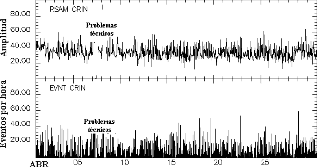 |
Figure 10. Seismic amplitude RSAM (top) and number of earthquakes per hour (bottom) at San Cristóbal during April 2002. Courtesy INETER. |
On 23 May a strong gas column was observed at San Cristóbal. The Washington Volcanic Ash Advisory Center (VAAC) stated that a surface report had indicated strong activity near the summit. A plume was visible on satellite imagery drifting SW from the summit (figure 11). A video camera near the summit indicated that the altitude of the plume was relatively low, near ~3 km. The Washingon VAAC issued a second notice stating that according to INETER, the emissions consisted solely of gas. The VAAC noted that no plume was detected in satellite imagery later that day. INETER reported that the column was the result of rain in the crater that generated steam. No other phenomena were observed that could indicate an increase in the eruptive activity of the volcano.
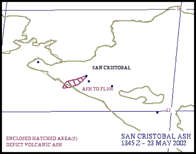 |
Figure 11. Sketch based on satellite imagery depicting a plume drifting SW from San Cristóbal on 23 May 2002. Courtesy NOAA. |
Geological Summary. The San Cristóbal volcanic complex, consisting of five principal volcanic edifices, forms the NW end of the Marrabios Range. The symmetrical 1745-m-high youngest cone, named San Cristóbal (also known as El Viejo), is Nicaragua's highest volcano and is capped by a 500 x 600 m wide crater. El Chonco, with several flank lava domes, is located 4 km W of San Cristóbal; it and the eroded Moyotepe volcano, 4 km NE of San Cristóbal, are of Pleistocene age. Volcán Casita, containing an elongated summit crater, lies immediately east of San Cristóbal and was the site of a catastrophic landslide and lahar in 1998. The Plio-Pleistocene La Pelona caldera is located at the eastern end of the complex. Historical eruptions from San Cristóbal, consisting of small-to-moderate explosive activity, have been reported since the 16th century. Some other 16th-century eruptions attributed to Casita volcano are uncertain and may pertain to other Marrabios Range volcanoes.
Information Contacts: Virginia Tenorio, Department of Geophysics, Instituto Nicaragüense de Estudios Territoriales (INETER), P.O. Box 1761, Managua, Nicaragua (URL: http://www.ineter.gob.ni/); La Noticia (URL: http://www.lanoticia.com.ni/); El Nuevo Diario (URL: http://www.elnuevodiario.com.ni/); La Prensa (URL: http://www.laprensa.com.ni/); Washington Volcanic Ash Advisory Center (VAAC), Satellite Analysis Branch, NOAA/NESDIS/E/SP23, NOAA Science Center Room 401, Camp Springs, MD 20746, USA (URL: http://www.ssd.noaa.gov/).