Report on Popocatepetl (Mexico) — June 2002

Bulletin of the Global Volcanism Network, vol. 27, no. 6 (June 2002)
Managing Editor: Richard Wunderman.
Popocatepetl (Mexico) Dome extrusions continue, accompanied by minor explosions
Please cite this report as:
Global Volcanism Program, 2002. Report on Popocatepetl (Mexico) (Wunderman, R., ed.). Bulletin of the Global Volcanism Network, 27:6. Smithsonian Institution. https://doi.org/10.5479/si.GVP.BGVN200206-341090
Popocatepetl
Mexico
19.023°N, 98.622°W; summit elev. 5393 m
All times are local (unless otherwise noted)
During March through at least late June 2002, volcanic activity at Popocatépetl consisted of small-to-moderate, but at times explosive, eruptions of steam, gas, and generally minor amounts of ash, along with episodes of harmonic tremor. Ash clouds rose up to ~2 km above the summit. Because of the remote location and high elevation of the summit, the dome growth within the crater was often hard to constrain, although seismicity and occasional flights over the summit did shed light on the situation. The following report is compiled from updates from the Centro Nacional de Prevencion de Desastres (CENAPRED) and from reports issued by the Washington Volcanic Ash Advisory Center (VAAC).
March began with activity at low and steady levels with up to 18 small steam-and-gas emissions per day and occasional episodes of harmonic tremor. The amount of ash emitted was generally minor. Occasional M 3 volcano-tectonic (VT) events were recorded. Low fumarolic activity began on 4 March and was frequently visible throughout the report period. Overflight observations on 7 March confirmed the presence of a lava dome in the crater (figure 44). A gas-and-steam plume reached ~2 km above the crater on 9 March. According to CENAPRED, the activity implied the possibility of low-level explosive activity in the coming days or weeks.
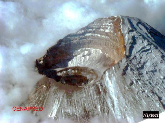 |
Figure 44. Aerial view from the NE on 7 March 2002 of the crater of Popocatépetl. The darkest circle in the center of the crater represents the newest lava-dome growth. Courtesy CENAPRED. |
Activity increased during 26-27 March when 42 gas and steam emissions reached 200-500 m above the crater, accompanied by small amounts of ash and low-amplitude harmonic tremor. The Washington VAAC issued a volcanic ash warning based upon seismic observations that indicated a possible ash-bearing eruption, but no ash was visible in satellite images. Activity decreased to levels similar to earlier in the month and continued at those levels through early April.
At 0438 on 8 April, observers recorded a moderate eruption with explosive characteristics accompanied by some visible incandescence. An accompanying ash cloud moved E towards the coastline and diffused within 24 hours. After a M 2.3 VT earthquake was recorded at 0545 on 8 April, activity returned to steady levels.
Activity remained low through mid-April, with the exception of a brief period around 11 April when observers detected a slight increase in low-amplitude tremor and fumarolic activity. An increased number of small-to-moderate exhalations per day (up to 52) accompanied by episodes of low-level harmonic and high-frequency tremor, and weak VT earthquakes characterized increased activity that began in late April and lasted through early May. According to CENAPRED, this activity was most likely related to motion of small amounts of magma towards the surface and growth of the lava dome within the crater.
An air photo taken on 29 April (figure 45) by the Department of Federal Roads showed a small dome ~170 m in diameter. On 1 May CENAPRED reported an ash plume moving W at 1.0 km above the summit. No ash was visible on satellite imagery.
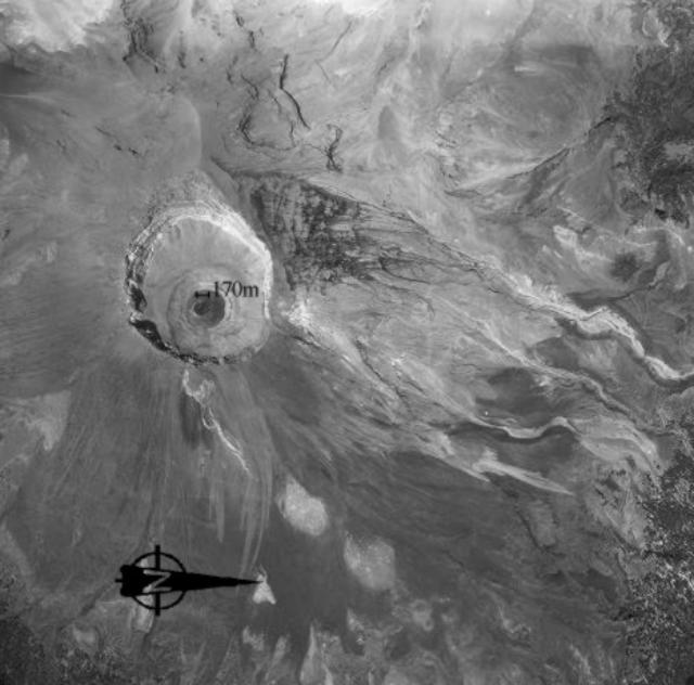 |
Figure 45. Air photo of the Popocatépetl crater taken by the Department of Federal Roads on 29 April 2002. The darkest circle in the left-center of the photo is the newest lava dome, measuring 170 m across. Subsequent flights indicated that explosive activity on 12 May destroyed part of this dome. Courtesy CENAPRED. |
Activity increased slightly during mid-May with 33 small-to-moderate exhalations and 1 hour of low-amplitude tremor on 10 May. At 0609 on 12 May, a small explosive eruption occurred, ejecting incandescent fragments on the N flank up to 500 m from the crater. During the next few days, CENAPRED reported increased numbers of exhalations per day (up to 124 on 14 May) of steam, gas, and sometimes small amounts of ash. It was later determined from overflight observations that this explosive activity destroyed part of the growing dome.
This period of increased activity decreased beginning around 17 May. During the rest of May, activity was again characterized by numerous (up to 66) small-to-moderate gas-and-steam exhalations accompanied by small amounts of ash and periods of harmonic tremor. Fumarolic activity continued at the surface. A pilot reported an ash cloud in the region on 21 May.
Activity declined to steady, low levels through June with the average number of exhalations per day dropping to less than 10, occasional isolated harmonic tremor episodes of ~15 minutes duration, and as many as five VT earthquakes per day (M 2.5).
On 17 June at 1136 an ash plume extended up to 2 km above the summit and drifted to the WSW. Shortly thereafter, CENAPRED recorded high-frequency tremor for almost 8 hours and four VT events (M 2.0-2.2). The resulting ash cloud moved across Mexico to the SW. During the following days the volcano quieted but continued to emit gas, steam, and ash in small quantities with episodes of harmonic tremor lasting less than an hour. On 27 and 29 June ash plumes reaching up to 2 km above the summit were accompanied by periods of harmonic tremor lasting up to 2 hours. The Alert Level remained at Yellow throughout the report period.
Geological Summary. Volcán Popocatépetl, whose name is the Aztec word for smoking mountain, rises 70 km SE of Mexico City to form North America's 2nd-highest volcano. The glacier-clad stratovolcano contains a steep-walled, 400 x 600 m wide crater. The generally symmetrical volcano is modified by the sharp-peaked Ventorrillo on the NW, a remnant of an earlier volcano. At least three previous major cones were destroyed by gravitational failure during the Pleistocene, producing massive debris-avalanche deposits covering broad areas to the south. The modern volcano was constructed south of the late-Pleistocene to Holocene El Fraile cone. Three major Plinian eruptions, the most recent of which took place about 800 CE, have occurred since the mid-Holocene, accompanied by pyroclastic flows and voluminous lahars that swept basins below the volcano. Frequent historical eruptions, first recorded in Aztec codices, have occurred since Pre-Columbian time.
Information Contacts: Centro Nacional de Prevencion de Desastres (CENAPRED), Delfin Madrigal 665, Col. Pedregal de Santo Domingo, Coyoacán, 04360, México D.F. (URL: https://www.gob.mx/cenapred/); Washington Volcanic Ash Advisory Center (VAAC), Satellite Analysis Branch (SAB), NOAA/NESDIS E/SP23, NOAA Science Center Room 401, 5200 Auth Road, Camp Springs, MD 20746, USA (URL: http://www.ssd.noaa.gov/).