Report on Ulawun (Papua New Guinea) — August 2002
Bulletin of the Global Volcanism Network, vol. 27, no. 8 (August 2002)
Managing Editor: Richard Wunderman.
Ulawun (Papua New Guinea) Ash eruptions during August 2002; plumes visible on satellite imagery
Please cite this report as:
Global Volcanism Program, 2002. Report on Ulawun (Papua New Guinea) (Wunderman, R., ed.). Bulletin of the Global Volcanism Network, 27:8. Smithsonian Institution. https://doi.org/10.5479/si.GVP.BGVN200208-252120
Ulawun
Papua New Guinea
5.05°S, 151.33°E; summit elev. 2334 m
All times are local (unless otherwise noted)
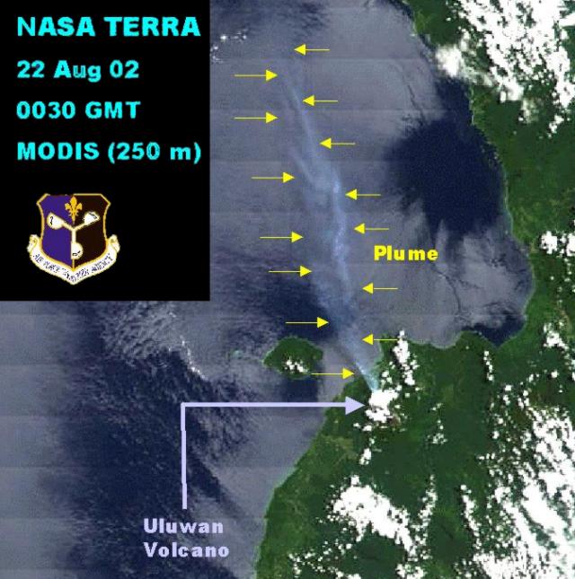
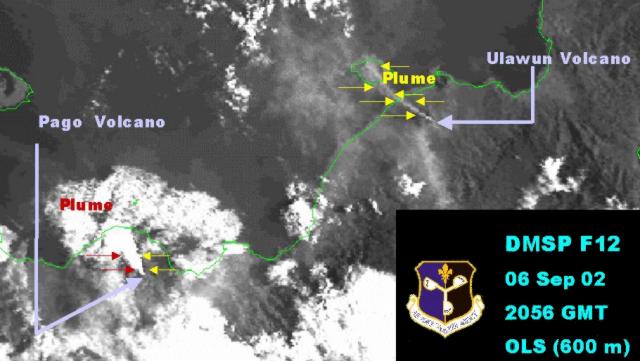
A NNW-trending plume was visible from Ulawun on MODIS imagery on 22 August 2002 (figure 6). The Darwin VAAC reported that on 28 August at 0732 a low-level ash cloud from an eruption at Ulawun was visible on satellite imagery. By 1532 the same day ash was no longer visible. According to a Post-Courier news article, ash eruptions had occurred on 26 August and during the previous week, but became larger on the 27th. As of the 28th, care centers were preparing for possible evacuations. NASA satellite images provided by the Air Force Weather Agency showed a NW-trending plume on 6 September (figure 7). The next day the Darwin VAAC reported a low-level (less than ~3.6 km altitude) ash plume visible on satellite imagery, extending NW.
 |
Figure 6. MODIS imagery on 22 August 2002 at 0030 (UTC) shows a NNW-trending plume from Ulawun. The land appears slightly darker in the image than the sea. Courtesy Air Force Weather Agency. |
 |
Figure 7. MODIS imagery on 6 September 2002 at 2056 (UTC) shows a NW-trending plume from Ulawun. Courtesy Air Force Weather Agency. |
Geological Summary. The symmetrical basaltic-to-andesitic Ulawun stratovolcano is the highest volcano of the Bismarck arc, and one of Papua New Guinea's most frequently active. The volcano, also known as the Father, rises above the N coast of the island of New Britain across a low saddle NE of Bamus volcano, the South Son. The upper 1,000 m is unvegetated. A prominent E-W escarpment on the south may be the result of large-scale slumping. Satellitic cones occupy the NW and E flanks. A steep-walled valley cuts the NW side, and a flank lava-flow complex lies to the south of this valley. Historical eruptions date back to the beginning of the 18th century. Twentieth-century eruptions were mildly explosive until 1967, but after 1970 several larger eruptions produced lava flows and basaltic pyroclastic flows, greatly modifying the summit crater.
Information Contacts: Darwin Volcanic Ash Advisory Center (VAAC), Bureau of Meteorology, Northern Territory Regional Office, PO Box 40050, Casuarina, NT 0811, Australia (URL: http://www.bom.gov.au/info/vaac/); Charles Holliday, Air Force Weather Agency (AFWA), Satellite Applications Branch, Offutt AFB, NE 68113-4039; Post Courier Online, http://www.postcourier.com.pg/20020828/news09.

