Report on Tungurahua (Ecuador) — August 2002

Bulletin of the Global Volcanism Network, vol. 27, no. 8 (August 2002)
Managing Editor: Richard Wunderman.
Tungurahua (Ecuador) High seismicity, lava fountains, and explosions during January-June 2002
Please cite this report as:
Global Volcanism Program, 2002. Report on Tungurahua (Ecuador) (Wunderman, R., ed.). Bulletin of the Global Volcanism Network, 27:8. Smithsonian Institution. https://doi.org/10.5479/si.GVP.BGVN200208-352080
Tungurahua
Ecuador
1.467°S, 78.442°W; summit elev. 5023 m
All times are local (unless otherwise noted)
This report discusses activity at Tungurahua during January-June 2002. Table 6 provides weekly totals of seismicity, which has decreased since January 2002 (figure 16). Overall seismicity (figure 17) was dominated by long-period (LP) earthquakes, emissions, few volcano-tectonic (VT) earthquakes, and occasional small explosions.
Table 6. Weekly totals of seismicity at Tungurahua during 1 January-30 June 2002. The LP data are also shown plotted on a histogram (figure 17). Courtesy of IG.
| Date | Long-Period | Hybrid |
| 01 Jan-06 Jan 2002 | 687 | 1 |
| 07 Jan-13 Jan 2002 | 306 | 5 |
| 14 Jan-20 Jan 2002 | 112 | 0 |
| 21 Jan-27 Jan 2002 | 715 | 1 |
| 28 Jan-03 Feb 2002 | 1685 | 0 |
| 04 Feb-10 Feb 2002 | 444 | 1 |
| 11 Feb-17 Feb 2002 | 570 | 1 |
| 18 Feb-24 Feb 2002 | 517 | 0 |
| 25 Feb-03 Mar 2002 | 435 | 1 |
| 04 Mar-10 Mar 2002 | 595 | 0 |
| 11 Mar-17 Mar 2002 | 587 | 0 |
| 18 Mar-24 Mar 2002 | 434 | 1 |
| 25 Mar-31 Mar 2002 | 232 | 2 |
| 01 Apr-07 Apr 2002 | 198 | 6 |
| 08 Apr-14 Apr 2002 | 15 | 0 |
| 15 Apr-21 Apr 2002 | 447 | 3 |
| 22 Apr-28 Apr 2002 | 332 | 3 |
| 29 Apr-05 May 2002 | 287 | 0 |
| 06 May-12 May 2002 | 316 | 2 |
| 13 May-19 May 2002 | 184 | 0 |
| 20 May-26 May 2002 | 204 | 0 |
| 27 May-02 Jun 2002 | 248 | 0 |
| 03 Jun-09 Jun 2002 | 110 | 0 |
| 10 Jun-16 Jun 2002 | 112 | 0 |
| 17 Jun-23 Jun 2002 | 37 | 0 |
| 24 Jun-30 Jun 2002 | 248 | 0 |
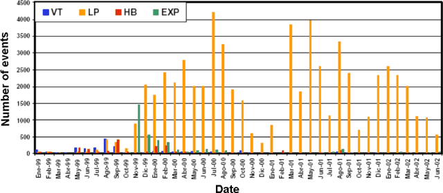 |
Figure 16. An overview of seismic events registered monthly at Tungurahua during January 1999-June 2002. After early 2000, the record was dominated by LP events. Courtesy IG. |
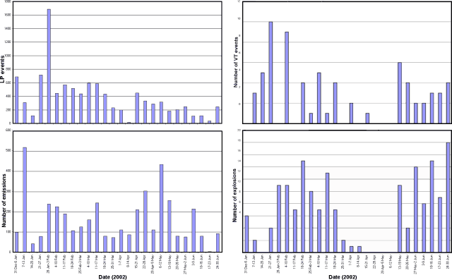 |
Figure 17. Summary of weekly seismicity at Tungurahua during January-June 2002. The number of long-period (LP) seismic events underwent a several-fold decrease later in the year. The number of emission signals was quite variable and remained abundant through the end of June 2002. Although volcano-tectonic (VT) seismic events were variable, the highest number appeared early in the reporting interval (during parts of both January and February). The number of explosion signals varied from 0-18 events/week during the reporting interval and except for a quiet period around late March to early May, continued unabated. Courtesy IG. |
Most of the LP earthquakes were shallow and associated with the exit of gases. Events during February included continuous emissions, intense fumarolic activity, tremor, and clusters of LP events (reaching more than 150 events/day, some with high amplitudes). These events were probably generated by gases associated with a small volume of new magma injected during late January, when VT earthquakes occurred several kilometers below the summit. That injection, like previous ones, accompanied the emission of steam and ash, and the possible formation of a lava lake that showed Strombolian activity. Tungurahua again responded to the injection of magma during March, when a few impressive lava flows occurred.
The Istituto Geofisico reported that shallow and deep events during May probably occurred in response to another small injection of magma beginning in mid-April, when tremor was especially high. Deformation data generally showed some deflation, and SO2 values fluctuated. The Washington VAAC frequently reported plumes and hot spots visible in satellite imagery (table 7). A more detailed description of the activity during January-June follows.
Table 7. Tungurahua plumes and hot spots visible in satellite imagery during January-June 2002. Note that the table only includes reports of plumes and hot spots visible in satellite imagery; IG reported plumes more frequently though clouds often prevented their appearance on satellite imagery. IG also made seismically based estimates of explosions. Times are listed in UTC as originally reported. Courtesy Washington VAAC.
| Date | Time (UTC) | Satellite observation (heights refer to altitude) |
| 03 Jan 2002 | 2300 | Possible small ash cloud near summit. |
| 04 Jan 2002 | 1445 | Hot spot. |
| 16 Jan 2002 | 1330 | Faint ash plume extending 34 km from the summit, estimated up to ~7.6 km. |
| 27 Jan 2002 | 0000 | Small ash cloud SW of the summit. |
| 27 Jan 2002 | 1700 | Ash plume E of the volcano, estimated up to ~9 km. |
| 03 Feb 2002 | 1930 | Faint ash plume, estimated at ~7.9 km. |
| 04 Feb 2002 | 0130 | Continuous faint ash plume extending 20 km N from the summit, estimated at ~7 km. |
| 08 Feb 2002 | 1330 | Narrow plume of ash and steam extending SE from the summit; estimated up to ~5.5 km. |
| 09 Feb 2002 | 1240 | Hot spot and faint narrow plume to the NE of the summit. |
| 09 Feb 2002 | 1600 | Narrow ash-and-steam plume moving SW at a higher level than the previous one. |
| 10 Feb 2002 | 2220 | Possible ash cloud W of the summit. |
| 11 Feb 2002 | 0030 | Eruption around 2230 resulted in a small ash cloud moving SW near ~7.6 km. |
| 13 Feb 2002 | 1815 | Thin plume of ash extended W at ~7 km. |
| 14 Feb 2002 | 1255 | Faint ash plume extending to the W, estimated at ~7 km. |
| 14 Feb 2002 | 2240 | Possible eruption around 1930 resulted in a small ash cloud towards the SE. |
| 15 Feb 2002 | 0450 | Ash no longer visible but hot-spot activity occurred during the previous 6 hours. |
| 15 Feb 2002 | 2230 | New eruption beginning around 2000, ash visible extending NW from the summit. |
| 21 Feb 2002 | 1440 | Very faint ash. |
| 26 Feb 2002 | 1245 | Narrow ash plume extending W, estimated at ~7.6 km. |
| 26 Feb 2002 | 1900 | Narrow ash plume extending W, estimated at ~7 km. |
| 27 Feb 2002 | 1300 | Possible narrow ash-and-steam plume extending to the NW of the volcano, estimated at ~6 km. |
| 10 Mar 2002 | 1645 | Small plume moving W from the volcano. |
| 15 Mar 2002 | 1415 | Ongoing ash-and-steam emission. |
| 17 Mar 2002 | 0430 | Ongoing ash emission and hot-spot activity. |
| 17 Mar 2002 | 1030 | Ongoing ash emission, new ash visible near summit, intermittent hot-spot activity. |
| 19 Mar 2002 | 0248 | Eruption began around 2130. |
| 22 Mar 2002 | 1400 | Narrow ash plume extending to the NW, estimated up to ~6.7 km. |
| 23 Mar 2002 | 2217 | Very narrow ash plume sincerely of summit. |
| 28 Mar 2002 | 0035 | Ash plume extending NW from the summit. |
| 28 Mar 2002 | 2205 | Ash plume moving W from the summit. |
| 12 Apr 2002 | 1440 | Narrow steam-and-ash plume extending to the SE of the summit. |
| 12 Apr 2002 | 2100 | Thin plume moving ESE. |
| 16 Apr 2002 | 1345 | Ash moving SW. |
| 19 Apr 2002 | 1240 | Small ash plume moving NW ~7 km from the summit. |
| 24 Apr 2002 | 1400 | Narrow ash plume extending to the SW, estimated up to ~7.6 km. |
| 28 Apr 2002 | 1430 | Thin ash cloud. |
| 13 May 2002 | 2350 | Ash cloud moving NW. |
| 14 May 2002 | 2230 | Possible ash moving NW. |
| 02 Jun 2002 | 1330 | Thin ash plume moving W. |
| 04 Jun 2002 | 2200 | Very thin line of ash extending to the W. |
| 07 Jun 2002 | 1245 | Narrow ash plume extending to the W. |
| 12 Jun 2002 | 2300 | Very narrow plume of ash extending to the W. |
| 13 Jun 2002 | 0500 | Hot spots. |
| 15 Jun 2002 | 0000 | Faint ash plume moving W from the summit. |
Activity during January-June 2002. During January 2002 steam plumes, sometimes with a little ash, were emitted almost continuously and generally reached less than 1 km high. Emissions and explosions were accompanied by moderate ash reaching 3-5 km. SO2 measurements on 13 January revealed a value of 1,030 tons/day, and a few days later had decreased to 290 tons/day. Beginning on 15 January, incandescence was observed in the crater and roaring sounds were heard from nearby villages. On 22 January, two volcano-tectonic (VT) events occurred at 0622, located at a depth of ~4 km. The VT events preceded a small cluster of long-period (LP) earthquakes and an explosion with a reduced displacement (RD) of 9.5 cm2.
On 24 January two VT events were registered at 0504 and 0605, located at depths of 5 and 4.4 km, respectively. The events preceded the occurrence of an LP cluster with dominant frequencies around 1.8, 2.4, and 3.8 Hz. Roaring sounds accompanied some of the LP earthquakes. Steam was emitted continuously and reached a height of 1 km before drifting W.
A cluster of LP events was registered on 25 January during 0700-1000 (with frequencies of 2.6-3.2 Hz); it was followed by emission signals. About 30 minutes later LP earthquakes increased and the settlements of Juive and Cusua (WNW flank) reported rockfalls. During 1000-1440 a 20-minute-long episode of harmonic tremor occurred followed by another LP cluster.
On 26 January during 1508-1629, two VT events occurred at depths of 5 and 7.5 km. One hour later, at 1739, an explosion took place with a RD of 7.2cm2. After the explosion, tremor was recorded and LP events continued for about 2 hours. For most of the activity, LP events preceded the explosions, and the seismicity was concentrated mostly at 5-7 km depth. VT events were mostly located 4-11 km beneath the summit and were aligned in a NNE direction.
LP earthquakes during late January through early February were associated with banded tremor during 24-28 January. A total of eight episodes of banded tremor were detected in one week, lasting 1-4 hours each. The LP earthquakes continued at an increased intensity at depths of 5-7 km beneath the summit. Small-to-moderate explosions also took place. On 28 January, an explosion occurred with a RD of 8.8 cm2. During these periods of increased tremor and LP events, the crater emitted gases and very little ash.
In early February a small amount of ash was deposited on the city of Ambato. Rain of moderate intensity caused mudflows to occur four times during February, with an especially large flow on 5 February.
On 4 February observations of the summit revealed new episodes of Strombolian activity, characterized by incandescence in the crater and by the ejection of large blocks to several hundred meters above the crater. During 11-18 February strong Strombolian activity was accompanied by pyroclastic flows that traveled part of the way to Juive and Cusua located on the WNW flank. Observers noted rapidly fluctuating incandescence in the crater, possibly due to disruptions in an inferred lava lake there. On 13 February a lava flow descended from the NNW part of the crater and extended 2 km below the summit. Beginning on 14 February both seismicity and incandescence decreased in intensity but ash emissions reached up to 2 km above the crater. During 18-25 February incandescence and roaring sounds decreased.
On 24 February a few large LP earthquakes occurred with 5 km focal depths and with RD values of more than 5 cm2. A tremor episode (with frequencies of 1.2-2.8 Hz) lasted ~25 minutes. During the night impressive Strombolian outbursts generated a flow of incandescent blocks. Banded tremor was associated with emissions of blocks and ash. This was followed by LP earthquakes associated with several hours of low activity. The intensity of the Strombolian activity diminished greatly with the absence of the LP earthquakes. Most of the LP events were located in a column 2-8 km beneath the summit. Some of the tremor episodes were located in the first 5 km beneath the summit. The explosions occurred at depths of 2-10 km.
During the last days of February roaring noises accompanied several cycles of Strombolian activity that were associated with lava fountains, and small ashfalls occurred on the W flank. By the end of February COSPEC measurements revealed an average value of 1,344 tons/day.
During the first weeks of March, most of the LP events were located 2-7 km beneath the summit, while the VT events were located 4-10 km beneath the summit. Some of the occasional explosions were impressive with large plumes, and some were preceded by important LP activity, suggesting the explosions were related to the ascent of gas bubbles that accumulated in the magmatic conduit. March emissions included steam, ash, and lava flows. Roaring sounds occurred almost continuously until the third week. Incandescence was observed in the crater twice during the last week of March, and a steam-and-ash plume was then visible reaching up to 2 km above the crater. Ashfall occurred in the cities of Ambato, Quero, Latacunga, Cusua, Chacauco, Penipe, Puela, Patate, Pelileo, Cotaló, and Pillate. COSPEC measurements revealed an increased average value of SO2 (>2,000 tons/day) compared to February (1,344 tons/day).
April was characterized by low seismicity, and nearly continuous tremor related to emissions of steam and ash. On 3 and 8 April two explosions occurred, with RD values of 7.3 cm2 and 4.5 cm2. Most of the LP events registered during April were small and rather sporadic. On 22 and 23 April, VT events occurred that were located at depths of 7.7 and 5.6 km, presumably related to the movement or evacuation of magmatic fluids. Following the VT events, strong steam-and-ash emissions occurred, accompanied by roaring noises and incandescence in the crater. This activity continued through the end of April and was especially strong during 24-30 April. Tremor energy decreased by the end of April. LP events were located 5-7 km beneath the summit. VT events were located at depths of 5-9 km.
During April a slight deformation was detected in the N flank. COSPEC-measured SO2 revealed low values; the mid-April average was 850 tons/day. A steam-and-ash column frequently reached up to 2 km high and drifted mainly NW. At times ash was deposited on the upper flanks. Lahars were also recorded, with the largest on 7 and 8 April. The number of LP and VT earthquakes, emissions, and tremor gradually increased during mid-May. The upper conduit filled with small volumes of magma so Strombolian activity, roaring noises, and incandescence in the crater was intense and almost continuous. During the last week of May columns of steam and ash were continuously emitted and drifted mainly W, and on 13 May, NW, depositing ash on Ambato and Baños.
During the second half of May noteworthy explosions took place on the 13th and 28th when nine and five explosions occurred, respectively, with RD values up to 7 cm2. Although similar activity continued throughout May, it was most intense during 12-13 and 28-30 May. VT events were located beneath the W-SW part of the crater at depths of 4-10 km. COSPEC-measured SO2 revealed a generally low average value of 950 tons/day during mid-May.
Strombolian activity was observed in early June along with lava fountains and incandescence. During the second week of June, the number of earthquakes and tremor episodes increased slightly and explosions occurred. The explosions were accompanied by loud noises and some by lava fountains that reached ~300 m above the summit. LP events were generally located 5-7 km beneath the summit and were thought to be related to magma injection. The VT events were located below the SW part of the crater at a depth of 4-7 km.
During the last week of June seismicity increased, followed by an important tremor episode. Powerful tremor occurred during a 3-day period (28-30 June) and was noteworthy because of the temporal variation of the frequencies from 1.5-2.7 Hz. The tremor sometimes lasted up to 1 hour with one amplitude that saturated seismograms. Many large LP events accompanied the tremor (RD over 10 cm2). Little surface activity accompanied the tremor and large LP events. The lack of an increase in the volume of ash and gas emitted seems to indicate that the gas is still trapped within the volcano and that it will eventually be released through intermittent activity or explosions. COSPEC-measured SO2 flux revealed a value of 1,800 tons/day. EDM measurements around that time indicated that the volcano inflated slightly.
Geological Summary. Tungurahua, a steep-sided andesitic-dacitic stratovolcano that towers more than 3 km above its northern base, is one of Ecuador's most active volcanoes. Three major edifices have been sequentially constructed since the mid-Pleistocene over a basement of metamorphic rocks. Tungurahua II was built within the past 14,000 years following the collapse of the initial edifice. Tungurahua II collapsed about 3,000 years ago and produced a large debris-avalanche deposit to the west. The modern glacier-capped stratovolcano (Tungurahua III) was constructed within the landslide scarp. Historical eruptions have all originated from the summit crater, accompanied by strong explosions and sometimes by pyroclastic flows and lava flows that reached populated areas at the volcano's base. Prior to a long-term eruption beginning in 1999 that caused the temporary evacuation of the city of Baños at the foot of the volcano, the last major eruption had occurred from 1916 to 1918, although minor activity continued until 1925.
Information Contacts: Patty Mothes, Geophysical Institute (Instituto Geofísico, IG), Escuela Politécnica Nacional, Apartado 17-01-2759, Quito, Ecuador, Washington Volcanic Ash Advisory Center (VAAC), Satellite Analysis Branch (SAB), NOAA/NESDIS E/SP23, NOAA Science Center Room 401, 5200 Auth Road, Camp Springs, MD 20746, USA (URL: http://www.ospo.noaa.gov/Products/atmosphere/vaac/).