Report on Papandayan (Indonesia) — November 2002
Bulletin of the Global Volcanism Network, vol. 27, no. 11 (November 2002)
Managing Editor: Richard Wunderman.
Papandayan (Indonesia) Large explosive eruption with landslide and lahars begins 11 November 2002
Please cite this report as:
Global Volcanism Program, 2002. Report on Papandayan (Indonesia) (Wunderman, R., ed.). Bulletin of the Global Volcanism Network, 27:11. Smithsonian Institution. https://doi.org/10.5479/si.GVP.BGVN200211-263100
Papandayan
Indonesia
7.32°S, 107.73°E; summit elev. 2665 m
All times are local (unless otherwise noted)
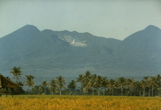
On 11 November 2002 a substantial eruption began at Papandayan. The last reported activity here, during June 1998, consisted of increased seismicity and minor phreatic explosions that ejected mud and gas (BGVN 23:07). The volcano lies ~50 km SE of Bandung.
The Volcanological Survey of Indonesia (VSI) reported that the seismograph recorded a deep volcanic earthquake in early October 2002. During mid-October, hypocenters of shallow volcanic earthquakes were migrating toward the surface. Volcanic earthquakes continued until the eruption.
One or more earthquakes at 0452 and 0454 on 11 November were felt with a Modified Mercalli intensity of II. The shaking is thought to have triggered instability at Papandayan. Associated tremor signals during 1200-1506 had ~6 mm amplitudes (peak-to-peak).
At 1530 on 11 November a phreatic eruption vented from the 1942 crater, Kawah Baru. An hour and 20 minutes later, a landslide began. The landslide, which occurred at the W wall of the old crater complex, advanced into the Cibeureum Gede river where it became a lahar and flood.
Figures 1, 2, and 3 show some of the near-source effects and processes seen two days after the 11 November eruption. The Cibeureum river is a tributary of the major, NNE-flowing Cimanuk river, which empties on Java's N coast. The lahar and flood destroyed eight houses, two bridges, and rice fields. News and web articles also mentioned some evacuations, damage to tea farms, and the reduced water-storage capacity of some impacted reservoirs. There were no reported deaths.
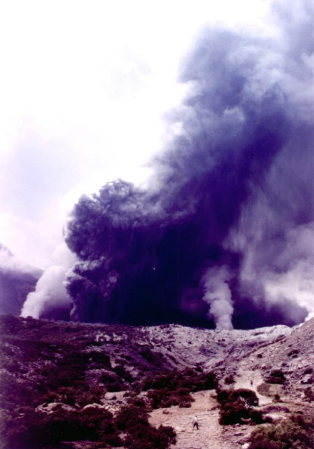 |
Figure 1. A photo showing Papandayan's phreatomagmatic eruption at Kawah Baru on 13 November 2002. For scale, note several people in open areas in the center foreground and beyond. Photo taken by Mas Atje Purbawinata (VSI). |
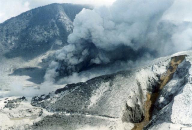 |
Figure 2. On 11 November 2002, Papandayan's cone Gunung Nangklak underwent slope failure at the old crater complex's W wall, leaving behind a fresh landslide scarp (right). The large cloud in the background consists of a modest background-level ash emission from Kawah Baru. Photograph taken on 13 November 2002 by R. D. Hadisantono (VSI). |
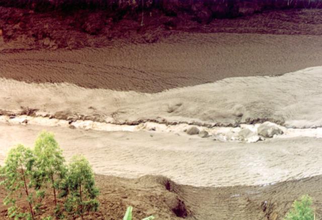 |
Figure 3. Papandayan's November eruption and landslide resulted in a lahar and flood on the Cibeureum Gede river. This is a view looking across a portion of that river as seen several days after the 11 November 2002 lahar and flood started. Downstream is towards the left. This photo taken on 13 November 2002 by Mas Atje Purbawinata (VSI). |
The eruption progressed into a phreatomagmatic (or magmatic) eruption until 14 November (figure 4). During this interval there were seven eruptive vents inside Kawah Baru; four of these discharged only sporadic magmatic eruptions, while three produced continuous ash eruptions. On the 14th, a total of 17 magmatic eruptions occurred between 0017 and 1150. The eruptions produced thick gray ash that reached 500-1,000 m above the vent.
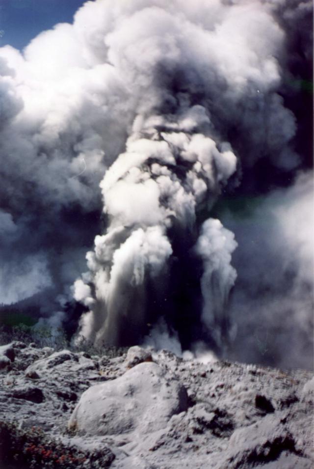 |
Figure 4. Papandayan discharges one of its many 14 November 2002 eruptions. Courtesy VSI. |
On 15 November at 0630 a larger eruption produced thick dark ash that reached 5.0 km above the summit. The Alert Level was raised to 4 (on a scale of 1-4).
On 16 November during 0600-1800 a thick white ash plume rose 300 m and drifted W. The seismograph recorded signals interpreted as intervals of continuous explosion, and continuous emission. The seismicity of that interval was also characterized by earthquakes (six volcanic, and one tectonic) and continuous tremor.
VSI reported that during 1800-0600 on 17-18 November, volcanic activity at Papandayan was dominated by ash emissions, while medium-pressure ash explosions occurred continuously. A thin white ash plume rose ~200-700 m above the crater and drifted W. The seismograph recorded explosion and tectonic earthquakes, along with continuous tremor and 2 volcanic earthquakes. Seismic signals also disclosed continuous emissions. The Alert Level was reduced to 3 at 1200 on 18 November.
On 19 November, a thick white ash plume of weak to medium pressure rose 200-500 m above the crater and drifted W. The seismograph recorded 11 shallow volcanic and 3 tectonic earthquakes, along with continuous tremor.
On 20 November a thick white ash plume reached 100-1,500 m above the crater and drifted W. Heavy rain occurred at 0502. An eruption from Nangklak crater produced a `dark-gray ash plume that reached 1.5 km above the crater and drifted NE, then N and NW. Ashfall reached a thickness up to 2 cm within a 2-km radius, directed towards the NW.
Earthquakes recorded on 20 November included 17 shallow volcanic, 1 deep volcanic, 2 tectonic, and 1 low frequency. Continuous tremor and continuous emissions of medium intensity also occurred.
A visit to the crater the next day confirmed that energetic eruptions had taken place on 20 November (figures 5, 6, and 7). Scientists found that a directed lateral blast had traveled NE as far as 2 km, stripping all trees growing along the inside of the horseshoe-shaped crater. Within this crater, the blast left blocks and smaller fragments of altered rocks and a 4-8 cm thick deposit of wet ash. Within a 500 m radius of the crater, the sides of some trees had charred due to contact with passing high-temperature gases from the blast, which had discharged from Nangklak crater (figure 6). Breadcrust bombs with maximum diameters of 50 cm were found around Nangklak crater.
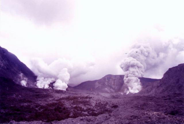 |
Figure 5. This 21 November 2002 photo documents Papandayan's multiple active vents. All the vents resided in craters within the volcano's larger horseshoe-shaped crater. Three white plumes issued from Baru crater (left), and one, more substantial plume came from the then very active Nangklak crater (right). Photographed by Igan S. Sutawidjaja (VSI). |
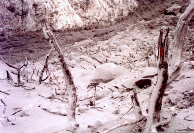 |
Figure 6. This photo was taken a day after Papandayan's 20 November eruption at a spot ~ 300 m from Nangklak crater. The area appears to be covered by an unspecified thickness of tephra. Widespread damage seen in the photo includes the near absence of smaller vegetation on the present ground surface, and the denuded, scorched, and splintered remnants of the larger vegetation. The charred sides of remaining tree stumps faced towards Nangklak crater. For scale, note the open jack-knife perched in the broken end of the closest tree. Photographed on 21 November 2002 by Igan S. Sutawidjaja (VSI). |
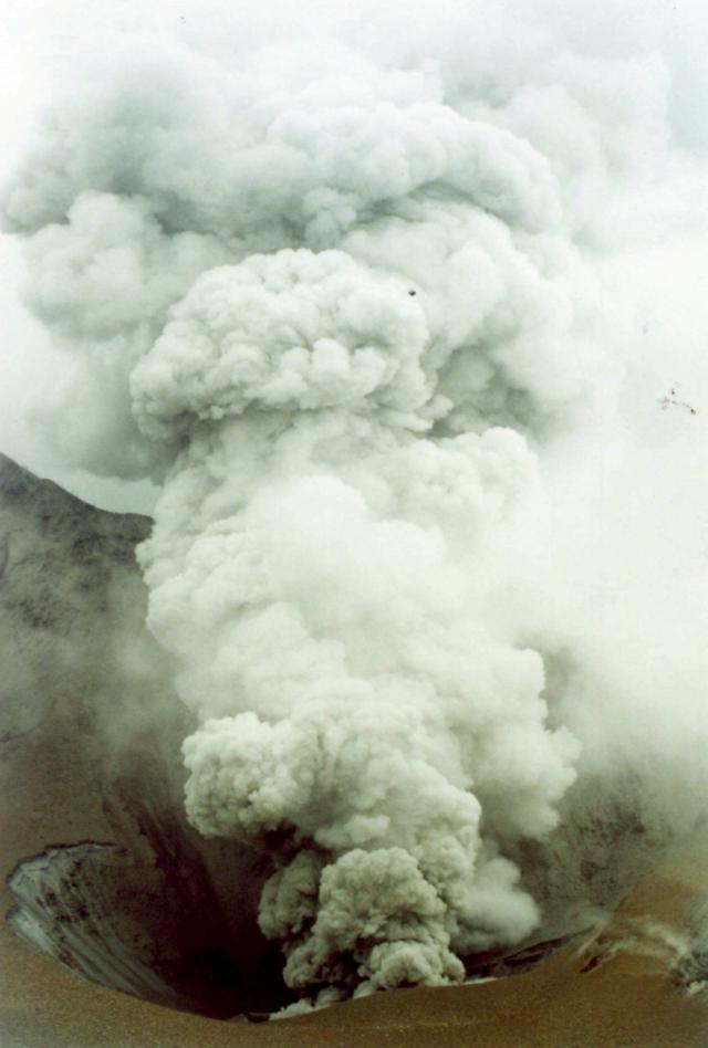 |
Figure 7. At Papandayan, ash explosions at Kawah Nangklak on 21 November 2002. Photographed by Igan S.Sutawidjaja (VSI). |
On 21 November, volcanism was dominated by explosions and ash emissions of medium-high intensity. Crater wall collapse also occurred, mostly at Kawah Baru. Through 0745 there were 98 explosions; they produced white gray ash that rose 200-600 m high and drifted W. The seismograph recorded a total of 10 shallow volcanic and 1 low-frequency earthquake, along with continuous tremor and emission (medium-high intensity). Citizens were asked to stay at least 4 km from the vent.
On 22 November there was a low level of continuous ash-and-gas explosions. A thick white plume with ash rose 300-600 m above Nangklak crater. Seismicity was dominated by explosion earthquakes (maximum amplitude, 23 mm) and also included shallow volcanic, deep volcanic, and tectonic earthquakes. A medium-intensity ash explosion along with lahars occurred along the Cibeureum Gede, and the Ciparugpug rivers.
During 23-25 November activity at Papandayan was dominated by ash explosions reaching more than 600 m above Nangklak crater. Six other craters emitted a white plume up to 200-400 m.
Geological Summary. Papandayan is a complex stratovolcano with four large summit craters, the youngest of which was breached to the NE by collapse during a brief eruption in 1772 and contains active fumarole fields. The broad 1.1-km-wide, flat-floored Alun-Alun crater truncates the summit of Papandayan, and Gunung Puntang to the north gives a twin-peaked appearance. Several episodes of collapse have created an irregular profile and produced debris avalanches that have impacted lowland areas. A sulfur-encrusted fumarole field occupies historically active Kawah Mas ("Golden Crater"). After its first historical eruption in 1772, in which collapse of the NE flank produced a catastrophic debris avalanche that destroyed 40 villages and killed nearly 3000 people, only small phreatic eruptions had occurred prior to an explosive eruption that began in November 2002.
Information Contacts: Volcanological Survey of Indonesia (VSI), Jalan Diponegoro No. 57, Bandung 40122, Indonesia (URL: http://www.vsi.esdm.go.id/).