Report on Pinatubo (Philippines) — December 2002

Bulletin of the Global Volcanism Network, vol. 27, no. 12 (December 2002)
Managing Editor: Richard Wunderman.
Pinatubo (Philippines) Likely 2001 overflow controled by cross-rim trenching
Please cite this report as:
Global Volcanism Program, 2002. Report on Pinatubo (Philippines) (Wunderman, R., ed.). Bulletin of the Global Volcanism Network, 27:12. Smithsonian Institution. https://doi.org/10.5479/si.GVP.BGVN200212-273083
Pinatubo
Philippines
15.13°N, 120.35°E; summit elev. 1486 m
All times are local (unless otherwise noted)
Pinatubo's catastrophic 1991 eruption left the volcano with a 2.5-km-wide summit caldera that eventually came to contain a lake (table 8). During 2001 a crisis occurred as the lake's surface neared the low point on the caldera's rim. PHIVOLCS provided a detailed report on trenching and release of lake water to avoid catastrophic breakout of the crater lake. The report that is summarized here was authored and contributed by Ma. Antonia V. Bornas and the Quick Response Team. The brief version given here omits the lengthy list of Team members as well as several figures and the references.
Table 8. Pinatubo crater-lake-water surface level through time and computed monthly and average lake-rise increments. See the original report for data sources. Courtesy PHIVOLCS.
| Date | Elevation | Maraunot freeboard | Monthly average | Cumulative monthly average | Annual average |
| June 1991 | 780.0 | 180.00 | -- | -- | -- |
| June 1995 | 830.0 | 130.00 | 1.042 | -- | 12.50 |
| June 1997 | 855.0 | 105.00 | 1.042 | 2.083 | 12.50 |
| 07 May 1998 | 915.0 | 45.00 | 5.455 | 7.538 | 65.45 |
| 27 Apr 1999 | 933.0 | 27.00 | 1.589 | 9.127 | 19.06 |
| 10 May 2000 | 942.0 | 18.00 | 0.726 | 9.853 | 8.72 |
| 28 Jun 2000 | 944.0 | 16.00 | 1.250 | 11.103 | -- |
| 05 Aug 2000 | 945.7 | 14.30 | 1.339 | 12.442 | -- |
| 16 Aug 2000 | 945.9 | 14.10 | 0.541 | 12.982 | -- |
| 16 Sep 2000 | 948.4 | 11.60 | 2.500 | 15.482 | -- |
| 13 Oct 2000 | 948.7 | 11.35 | 0.278 | 15.760 | -- |
| 23 Nov 2000 | 949.2 | 10.78 | 0.432 | 16.192 | -- |
| 27 Dec 2000 | 949.7 | 10.33 | 0.500 | 16.692 | -- |
| 27 Jun 2001 | 953.5 | 6.50 | 0.638 | 17.330 | -- |
| 11 Jul 2001 | 955.0 | 5.00 | 1.327 | 18.657 | 15.17 |
| Average | -- | -- | 1.166 | -- | 13.23 |
Mount Pinatubo's summit caldera lake surface rose 40 m between May 1998 and July 2001. By July 2001 lake water approached the caldera rim's lowest point, the Maraunot Notch (~960 m elevation). Its surface then stood at 955 m elevation, 5 m below the notch.
The record of the crater lake's rise implied overtopping of Maraunot Notch in the last quarter of 2001. A breach at Maraunot could lead to rapid escape of lake water into an area of abundant unconsolidated pyroclastic deposits (figure 35). Such an event would threaten upriver towns as well as the larger Botolan, Zambales (population ~40,000).
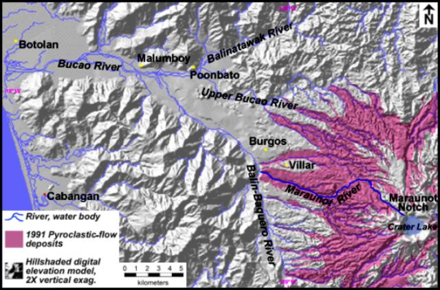 |
Figure 35. Digital terrain map of the NW Pinatubo quadrant, showing the Maraunot Notch and the contiguous Maraunot-Balin-Baquero-Bucau river system. Botolan town proper and upriver villages are shown. Digital elevations are from the PHIVOLCS-GIS lab. Sources include USGS (1991), Philippine Bureau of Mines (1983), and Fire and Mud (1996). Courtesy PHIVOLCS. |
The beheaded upper Maraunot river sits on the NW flank (figure 36) and flows 15 km NW into the Balin-Baquero river. Lahars have long threatened to inundate Botolan town proper. As with the 1991 pyroclastic flows, lahars obliterated villages in the Balin-Baquero and Bucao valleys (e.g. Villar, Burgos, and Poonbato).
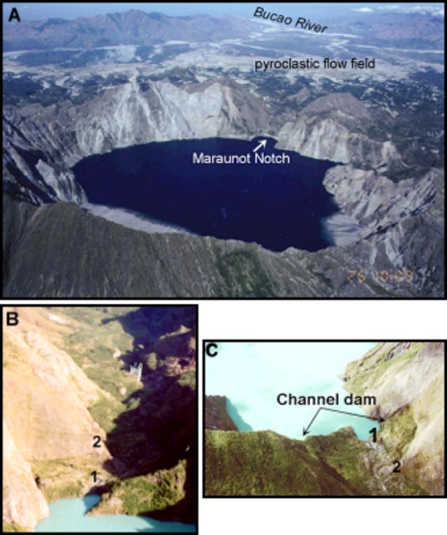 |
Figure 36. Oblique aerial photograph showing the Pinatubo crater, the Maraunot Notch, and the Maraunot-Bucao river system (looking NW) as seen in 2000. Photo courtesy of S. Suto, PHIVOLCS. |
Notch and dam characteristics. The valley of the Maraunot Notch contains 150-m-high walls composed of dome rocks and lithified block-and-ash deposits, cut by steep NW- and E-trending faults. Dome rocks also crop out within the first kilometer-long reach of the Maraunot channel and are inferred to form its bedrock. Less competent deposits fill the valley floor and edge off abruptly at the crater, damming the crater lake. This dam is approximately 85 m wide at the edge or crest but narrows as it slopes 8° down-valley to its toe at a prominence of dome rock 70 m away and 10 m below the crest (the nose).
Comprising the dam are a lower pre-1991 terrace of three boulder-rich breccia units and an upper sequence of 1991 deposits. Pre-1991 breccia units are poorly indurated and contain dense dacite-andesite clasts (median diameter, 10-15 cm) in coarse (B1) or fine (B2) ash or coarse sand (B3) matrix. Exposures of the dam in 1998 indicated that pre-1991 breccia may be as much as 14 m thick at the crest. The units also occur as in-channel terraces along the first 700-m reach of the Maraunot River. An overlying 1991 eruption sequence also occurs. It is unconsolidated and up to several meters thick, but has been gullied down to a meter thick along the channel thalweg, creating a 5 m-wide natural spillway at the dam's axis. Thus, unconsolidated 1991 eruption deposits at the dam's upper part left it vulnerable to rapid erosion and possible catastrophic breach.
A potential breach was expected on the occasion of intense rainfall. Dam failure was thought to be potentially initiated by erosion or headcutting of 1991 deposits where the valley narrows or "noses" and the channel drops. The removal of material would lead to increasing flow perimeter and head, which would increase discharge and weaken the dam. Discharge would escalate into a tremendous rush of water, accelerating erosion headward in a runaway process that culminated in dam failure. This same process has been documented in numerous cases of overtopped natural and man-made dams that have breached.
In the worst case, a 10- to 20-m-depth of the channel dam corresponding to the vertical gap between the crest and shallow channel bedrock could have been breached, releasing lake volumes of 28 x 106 to 55 x 106 m3. For a 10- to 20-m-deep breach, estimated peak discharges at the breach in such a circumstance are 3,000 and 11,000 m3/s. The breakout flow would be expected to erode and incorporate pyroclastic-flow and lahar sediments at the mid- to lower reaches of the Maraunot River, causing it to bulk up 3-6 times. Resulting large lahars could reach 3- to 7-fold larger distances than in previous typhoons (e.g. 1993). Faced with this hazard, PHIVOLCS proposed in early August 2001 to trench across the channel dam. This formed the core element of a rapid mitigation plan that included information drives, evacuation of risk areas, and lahar watches.
Trenching took place during 23 August-5 September 2001. The bulk of the trench was manually dug by an 80-man crew using pick axes and shovels and, later, by sluicing with a portable 50 m-long pressure hose. Excavation followed the channel thalweg or the natural spillway from crest to toe of the dam. The fully-excavated trench was 70 m long, 4 m wide, and nearly 3.5 m deep. It contained a 1-m-wide and 1.5-m-deep inner terrace that resulted from belated prioritization of depth over width (figures 37 and 38). Its bottom was originally graded ~2%. At the mouth it sloped steeply into 5 m-long plug that confined the lake until its release. In the end, about 700 m3 of material was excavated. On 4 September, observers were stationed at four sites. Evacuation of Botolan began the following day in anticipation of potential lahars.
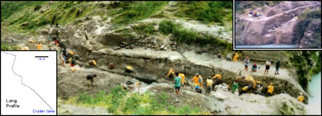 |
Figure 37. Oblique photo of Pinatubo's Maraunot Trench looking NE, taken the day before the channel was opened. Inset shows the mouth on 1 September 2001, ~ 2 m above the lake level; bottom lefthand inset is the profile of the trench. Courtesy PHIVOLCS. |
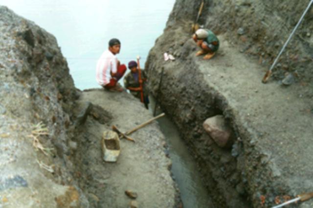 |
Figure 38. View showing of the mouth and the terraced inner geometry of the Pinatubo's Maraunot Trench, 6 September 2001. Courtesy PHIVOLCS. |
On 6 September, with a 10-cm-head of water, the plug was removed by sluicing. At 0653, after less than 1.25 hours of sluicing, lake water spill into the trench commenced, but discharge remained sluggish in the first four hours (~0.03 m3/s). Political developments led to the trench being left in a state that thwarted rapid, planned breaching.
Monitoring the newly opened trench. From 6 September to 5 November, local rainfall and outflow conditions and changes in configuration of the Maraunot trench were monitored. An estimated 4.4 x 10⁶ m3 (~86,000 m3/day) of rainwater entered the crater between 6 September and 5 November. In response, discharge across the trench fluctuated but rarely exceeded 1 m3/s under a lake head generally under 1 m. The total water output at the trench was roughly 3 x 10⁶ m3 (~59,000 m3/day) for the same period.
Time-series profiles of the trench floor revealed a total 1.5 m of downcutting in the period 8 September-21 October, an average of ~3.5 cm/day. As the terminus lowered close to bedrock and precipitation waned, however, the floor more or less stabilized, as did the trench's mouth-to-terminus elevation drop of 2.2 m. No substantial lateral erosion occurred at the 5-15 reach or in the first 30 m reach between 6 September and 5 November. Nevertheless, there was significant lateral erosion of as much as 2 m at the 55-65 m reaches and beyond. Erosion was attributed largely to the steeper channel and more turbulent flow at the trench's terminal reaches.
The pre-1991 breccia matrix eroded with vertical scour experienced uniformly across the entire floor and lateral scour (sidecutting) confined to the terminal reaches. Matrix erosion resulted in armoring of the trench floor with dense boulders. This partly accounted for restrained vertical scouring.
Trenching impacts to the lake breakout problem. Although the trench did not trigger a rapid breach as PHIVOLCS originally intended, the monitoring determined that the armoring provided by coarse pre-1991 breccia limited vertical scouring of the dam. Lateral matrix erosion and bank collapse were considered to deliver even further armor to the trench bed, as well as some sideways expansion of the channel.
Trenching by itself had significantly reduced the breakout hazard. The lake was averted from growing an extra 11 x 106 m3 and relieved of another 3 x 10⁶ m3 with a trench now draining it. This minimized the magnitude of lake breakout. Had natural overtopping been allowed to occur under sustained intense rainfall, initial outflow could have easily scoured a wider channel across the loose 1991 deposits, attaining discharge rates possibly too high for pre-1991 breccia to counteract with armoring.
Geological Summary. Prior to 1991 Pinatubo volcano was a relatively unknown, heavily forested lava dome complex located 100 km NW of Manila with no records of historical eruptions. The 1991 eruption, one of the world's largest of the 20th century, ejected massive amounts of tephra and produced voluminous pyroclastic flows, forming a small, 2.5-km-wide summit caldera whose floor is now covered by a lake. Caldera formation lowered the height of the summit by more than 300 m. Although the eruption caused hundreds of fatalities and major damage with severe social and economic impact, successful monitoring efforts greatly reduced the number of fatalities. Widespread lahars that redistributed products of the 1991 eruption have continued to cause severe disruption. Previous major eruptive periods, interrupted by lengthy quiescent periods, have produced pyroclastic flows and lahars that were even more extensive than in 1991.
Information Contacts: Ma. Antonia V. Bornas and theQuick Response Team, Geology and Geophysics Research and Development Division, Philippine Institute of Volcanology and Seismology, C.P. Garcia Ave., University of the Philippines Campus, Diliman 1101, Quezon City, Philippines.