Report on Tinakula (Solomon Islands) — January 2003
Bulletin of the Global Volcanism Network, vol. 28, no. 1 (January 2003)
Managing Editor: Edward Venzke.
Tinakula (Solomon Islands) Observers and infrared data indicate eruptive activity since 1989
Please cite this report as:
Global Volcanism Program, 2003. Report on Tinakula (Solomon Islands) (Venzke, E., ed.). Bulletin of the Global Volcanism Network, 28:1. Smithsonian Institution. https://doi.org/10.5479/si.GVP.BGVN200301-256010
Tinakula
Solomon Islands
10.386°S, 165.804°E; summit elev. 796 m
All times are local (unless otherwise noted)
Following an eruption and tsunami from Tinakula (figure 1) during September-December 1971 (CSLP Cards 1297, 1300, and 1301), there were brief reports of large steam plumes and ash plumes in June 1984 (SEAN 09:06) and June 1985 (SEAN 10:06). This report includes observations from a variety of sources. John Seach has provided information about activity during 1989-90 and 1995, as well as some insight into hazards faced by island residents in the area. Passengers on tour expedition ships noted continuing activity in May 1999 and November 2002. MODIS thermal alerts were triggered on three occasions during January-April 2001. In April 2002 excellent observations of eruptive activity were made by scientists on an Australian research vessel.
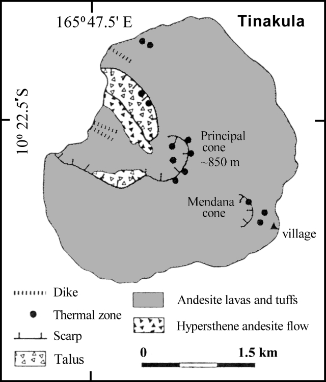 |
Figure 1. Sketch map of Tinakula island based on work and publications by G.W. Hughes (1972) and colleagues and summarized by Eissen and others (1991). |
Observations in 1989-90 and 1995. John Seach observed Tinakula volcano from the Reef Islands (54 km ENE) from August 1989 to February 1990. Typical activity consisted of Vulcanian eruptions and ash emission to 200-400 m above the summit. Eruptions occurred in distinct bursts separated by intervals ranging from minutes to hours. Reports from sailors indicated that lava bombs frequently rolled down to the sea on the NW side of the volcano, and glowing avalanches were observed at night.
Tinakula was approached by motorized canoe on two occasions in 1995, but dangerous seas made landing impossible. Ongoing ash emissions originated from the summit area. The upper slopes of the volcano were bare and exposed to gas emissions. Regions of mass wasting on the flanks were common, and blocks of lava and rubble were found at sea level at various locations around the island. However, some of the lower flanks were covered with thick vegetation. During a Solair flight from Santa Cruz to Honiara in late September 1995, activity was observed at the summit crater with ash emissions drifting several kilometers towards the W.
The island has not been inhabited since the tsunami in 1971, but islanders from the outer Reef Islands occasionally travel to tend gardens on the SE flank. The ocean between Santa Cruz Island and Reef Islands is dangerous, with many currents and high seas regularly capsizing boats. Landing on the island is always dangerous due to prevailing swells and the lack of a suitable beach. The dominant SE trade winds blow ash and gases away from inhabited islands for most of the year, but a large eruption occurring in westerly winds may affect populations in the Reef Islands. Volcanic bombs (5 cm in diameter) of an unknown age located in villages on the Reef Islands (over 50 km away) were reported to have fallen from the sky.
Observations during May 1999. On the morning of 16 May 1999, Matthew Mumford, on a sailing expedition aboard the Akademik Shuleykin, noted as they approached Tinakula that ". . . a cloud of darkness was blown skyward before our bow. As the ash moved across the sky, the contrast of gray against the white pillows of cloud gave a clear indication of how active this volcano continues to be."
MODVOLC Thermal Alerts, 2000-2002. MODIS alerts for Tinakula on 15 January 2001, 6 March 2001, and 16 April 2001 provide objective evidence of continued volcanic activity. The maximum alert ratio was low (-0.75), indicating small-scale activity. The absence of alerts since April 2001 was judged more likely to be because the level of activity has dipped below the -0.8 alert-ratio threshold rather than because of a genuine cessation of activity.
Observations during April 2002. Scientists from the RV Franklin briefly investigated Tinakula during the SOLAVENTS expedition, 26 March-21 April 2002. A vent high up on the W flank was actively expelling gas/steam, which could be heard as a low roar 50 m from shore. Small avalanches down the steep W side were common, and one larger eruption observed from the vessel's bridge lasted about 5 minutes. Small optical transmission anomalies were detected in the water column and are probably turbidity induced-particulate plumes. A weak methane anomaly was also recorded ~2.8 km off the NW coast of Tinakula. The following is based on extracts from the daily narrative section of the cruise report (McConachy and others, 2002).
The Franklin arrived ~3.2 km off the W coast of Tinakula at 0705 on 6 April 2002 (figures 2-5) and in perfect conditions the Zodiac rescue boat was deployed with Able Seaman Graham and scientists Richard Arculus and Donn Tolia to commence water sampling. The zodiac was safely back on deck by 0815. The scientists reported a roaring noise from Tinakula's active crater heard when the boat was 50 m offshore.
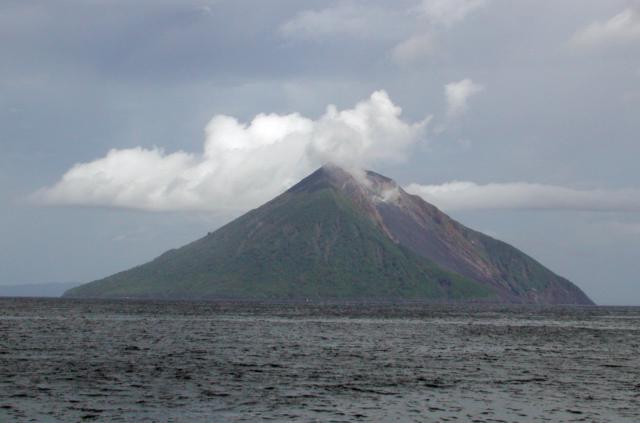 |
Figure 2. Photo showing the N coast of Tinakula as viewed from the zodiac boat off the R/V Franklin, 6 April 2002. The landslide scarp descends to the sea on the NW side of the island. Ndeni Island can be seen in the background S of Tinakula. Photographed by Donn Tolia, Director, Geological Survey of the Solomon Islands; courtesy of CSIRO. |
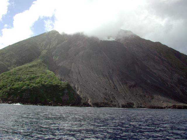 |
Figure 3. Close-up view of Tinakula showing the landslide scarp and embayment on the NW coast. The breached summit crater is mostly hidden by steam emissions. Photographed by Donn Tolia, Director, Geological Survey of the Solomon Islands; courtesy of CSIRO. |
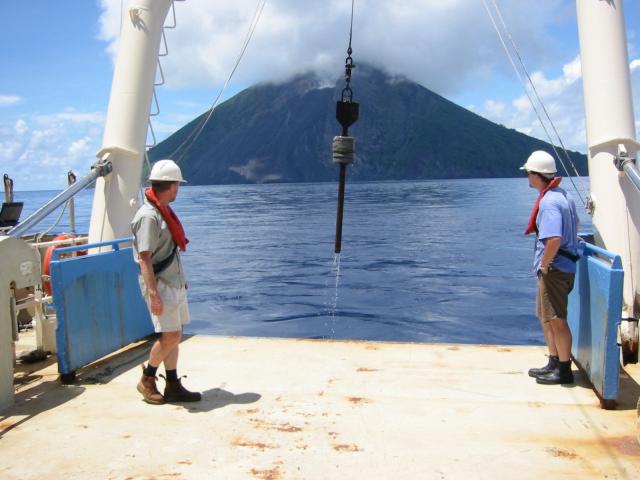 |
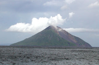
Figure 4. Photo of Tinakula taken from the RV Franklin, 6 April 2002. Photographed by Susan Belford; courtesy of CSIRO. |
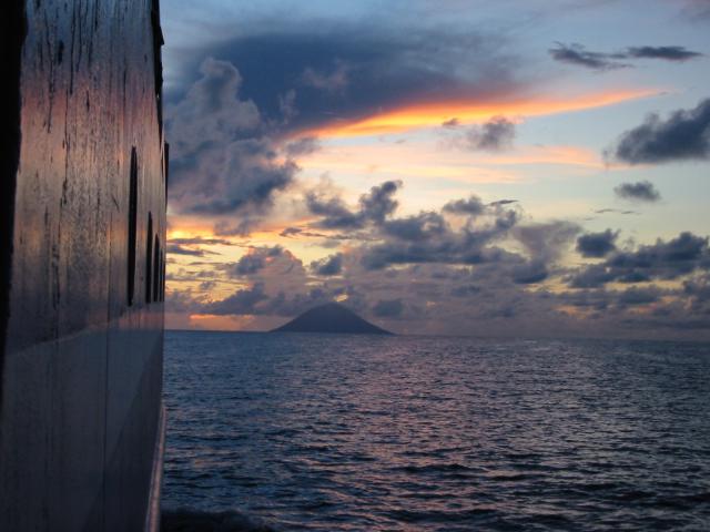 |
Figure 5. Photo of Tinakula in the distance taken from the RV Franklin, 6 April 2002. Photographed by Susan Belford; courtesy of CSIRO. |
From virtually the same location a grab sample collected material from the 1971 eruption at around 950 m depth. An excellent, 75%-full load of exceptionally well-sorted black volcanic sand was recovered, consisting of plagioclase, pyroxene and red-brown fragments; no foraminifera were visible. A CTD-Hydrocast followed at around 0910. During this operation, smoke came from a vent 2/3 way up the summit on the W side of the sector collapse, and minor avalanches came down scree slopes on the N side of the collapse area. A number of light transmission anomalies were observed on the down cast and sampled on the upcast. They are most likely particle plumes following isopycnals (constant density surfaces) sloughing off the main slope.
Observations during November 2002. Passengers on the Zegrahm Expeditions cruise ship Clipper Odyssey observed that Tinakula was "active" on the morning of 18 November 2002, but no description of the activity was provided.
References. McConachy, T.F., Yeats, C.J., Arculus, R.J., Beattie, R., Belford, S., Holden, J., Kim, J., MacDonald, L., Schardt, C., Sestak, S., Stevens, B., and Tolia, D., 2002, SOLAVENTS-2002: Solomons Australia Vents Expedition Aboard the RV Franklin, 26 March-21 April 2002, edited by C.J. Yeats, CSIRO Exploration and Mining Report 1026F, 456 p.
Hughes, G.W., 1972, Geological map of Tinakula: Nendö sheet EOI 1, Soloman Geol. Survey, Honiara.
Eissen, J-P., Blot, C., and Louat, R., 1991, Chronology of the historic volcanic activity of the New Hebrides island arc from 1595 to 1991: Rapports Scientifiques et Technique, Sciences de la Terre, No. 2, ORSTOM, France.
Geological Summary. The small 3.5-km-wide island of Tinakula is the exposed summit of a massive stratovolcano at the NW end of the Santa Cruz islands. It has a breached summit crater that extends from the summit to below sea level. Landslides enlarged this scarp in 1965, creating an embayment on the NW coast. The Mendana cone is located on the SE side. The dominantly andesitic volcano has frequently been observed in eruption since the era of Spanish exploration began in 1595. In about 1840, an explosive eruption apparently produced pyroclastic flows that swept all sides of the island, killing its inhabitants. Recorded eruptions have frequently originated from a cone constructed within the large breached crater. These have left the upper flanks and the steep apron of lava flows and volcaniclastic debris within the breach unvegetated.
Information Contacts: Timothy F. McConachy, CSIRO Exploration and Mining, PO Box 136, North Ryde, NSW 1670, Australia (URL: http://mnf.csiro.au/); Diego Coppola and David A. Rothery, Department of Earth Sciences, The Open University, Milton Keynes, MK7 6AA, United Kingdom; John Seach, PO Box 16, Chatsworth Island, NSW 2469, Australia (URL: http://www.volcanolive.com/); Jeff and Cynthia Gneiser, Zegrahm & Eco Expeditions, 192 Nickerson Street ##200, Seattle, WA 98109, USA (URL: https://www.zegrahm.com/); Matthew Mumford, Unit 1.02, 26 Kippax Street, Surrey Hills, NSW 2010, Australia.