Report on Yasur (Vanuatu) — January 2003

Bulletin of the Global Volcanism Network, vol. 28, no. 1 (January 2003)
Managing Editor: Edward Venzke.
Yasur (Vanuatu) Eruptive activity from the summit crater continued through 2002
Please cite this report as:
Global Volcanism Program, 2003. Report on Yasur (Vanuatu) (Venzke, E., ed.). Bulletin of the Global Volcanism Network, 28:1. Smithsonian Institution. https://doi.org/10.5479/si.GVP.BGVN200301-257100
Yasur
Vanuatu
19.532°S, 169.447°E; summit elev. 361 m
All times are local (unless otherwise noted)
Eruptive activity has continued at Yasur since a more vigorous phase began in October 2001 that lasted at least into January 2002 (BGVN 27:01). This report includes details for a period of mild activity during 24-28 July 2000 (not previously included in the Bulletin). Since that time visitors noted activity continuing in October 2000 and September 2001 (BGVN 26:11), as well as October and December 2001 (BGVN 27:01). Accounts are provided below of activity during January, August, November, and December 2002. Finally, MODIS thermal-alert data confirm intermittent lower level activity in 2001, and an increase in vigor beginning in August 2002.
Observations during July 2000. Roberto Carniel, Douglas Charley, and Marco Fulle arrived on Tanna Island on 24 July 2000 and camped at the base of the E slope of the cone. The lake that used to fill part of the surrounding Ash Plain had disappeared after heavy rains during the rainy season caused the overflow of the lake, damaging several houses in the village of Sulphur Bay. In the active crater, three smaller craters were distinguished, named A, B, and C, from left to right as seen from the E rim, where local guides bring tourists. This spot lies no more than 150 m from the most active C vents (figure 30). During the visit Crater B was slightly active, while Crater A appeared dormant.
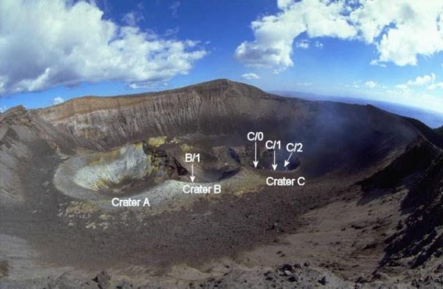 |
Figure 30. Photo showing the three subcraters within the active summit crater of Yasur, 24 July 2000. The N end of the island of Tanna and the Pacific Ocean can be seen in the right background. Courtesy of Marco Fulle. |
On the afternoon of 24 July the activity was moderate to high. Between 1620 and 1640 frequent spattering was observed by Carniel at the C/1 and C/2 vents. Between 1640 and 1820 eight eruptions were observed at vent C/0, with another 10 eruptions at vent C/1. On average the latter vent exhibited the bigger eruptions, in one case accompanied by gray emissions.
During the morning of 25 July the activity was again quite intense; observations were sometimes disturbed by a strong wind. Between 0825 and 0910 the explosions were mostly concentrated in the C/0 vent (six eruptions). Some of them were accompanied by the emission of brown ash at the end. During this period three silent explosions with only brown ash emitted were observed at vent B/1, completely inactive the previous day. C/1 showed only one eruption. After 20 minutes with no eruptions, from 0930 to 1130 the activity was mostly concentrated in the C/1 vent, where 17 eruptions were observed, some ended by a brown ash emission. The vent also showed about ten minutes of frequent spattering around 1120; during the same period B/1 vent produced two more silent ash eruptions and a brief spattering was observed at a vent, C/2, that looked different from C/1 but did not show any other activity after this. After 0930 vent C/0 did not show any activity.
During the afternoon, new visual observations were made by Carniel. From 1700 to 1725 very low activity was observed. Two successive silent brown ash eruptions from vent B/1 accompanied the start of a more intense phase for vent C/1. This vent erupted 15 times between 1725 and 1855, sometimes also showing continuous spattering and glow. Again no activity was seen at vent C/0.
During the morning of 26 July visual observations were made between 0835 and 1125. The first ten minutes were characterized by continuous and loud spattering at vent C/1, which showed a total of 18 explosions, some of them extremely loud and/or accompanied by the emission of gray ash. Vent C/0 showed only three eruptions, but all very loud and followed by a brown ash emission. One single silent ash eruption was observed at vent B/1 at 0945.
Carniel made other visual observations between 1700 and 1750 on the afternoon of 26 July, when the activity was characterized by a variable level of continuous spattering from vent C/1, which also showed 10 eruptions. During this period vent C/0 showed a single eruption at 1736. No activity was observed in crater B.
After a morning characterized by rain, Carniel and Fulle climbed the volcano again on the afternoon of 27 July. The air was still humid and gas stayed over the craters. The volcano was very quiet between the eruptions, with no sounds and no spattering at any vent. Between 1630 and 1730 there were 14 eruptions observed at vent C/1, but most of them were gas-rich emissions with very few bombs reaching the vent rim. Only two eruptions slightly bigger than spattering were observed at vent C/0.
On the morning of 28 July 2000, before leaving the volcano, the team made their last visual observations. Activity was moderate and visibility not very good. Many eruptions were very loud and they could be ascribed to C/1 from the sound alone, even when not visible. At 0920 a rockfall was heard from the S side of the caldera rim.
Observations during January 2002. The International Federation of Red Cross and Red Crescent Societies noted on 16 January 2002 that scientists were on alert for heightened volcanic activity at Yasur following a M 7.2 earthquake on 3 January. The earthquake produced landslides in Vanuatu's capital, Port Vila on Efate Island, and damaged buildings and bridges in the city, but there were no deaths or serious injuries. During 5 January to at least 16 January ash fell on Tanna Island, polluting water sources. The week of 6 January the Vanuatu government restricted access to the volcano's crater citing an increased risk of an eruption since the 3 January earthquake.
The Volcanic Ash Advisory Center in Wellington notified aviators of an eruption on 25 January around 1300. A pilot reported that the ash cloud rose to ~2 km altitude and slowly drifted S. The ash cloud was not visible on satellite imagery, possibly due to heavy meteorological cloud cover.
Observations during August 2002. The European Volcanological Society posted a report from the Institut de Recherche pour le Développement (IRD) on 3 September 2002. At that time the increasing level of activity at Yasur since October 2001 and the M 6 earthquake of 29 August 2002 had prompted IRD to upgrade the hazard status to Alarm Level 3, closing access to the volcano. The earthquake was strongly felt by residents of the entire district around the volcano. This was the first time since the seismic station was installed in October 1992 that a shock of such magnitude was recorded. Elders of the Yasur district confirmed that such an earthquake had not been experienced within living memory. The installation of two new seismological monitoring stations is planned, to complement the existing alarm system installed 2 km from Yasur and the Isangel station.
Observations during November 2002. On 22 November 2002 a group of passengers from the Zegrahm Expeditions cruise ship Clipper Odyssey visited the summit area. They observed Strombolian activity from one crater and heard thunderous whooshing sounds followed by thick yellow and white smoke from another.
Observations during December 2002. John Seach visited to the volcano on 7 December 2002, approaching by 4WD vehicle across the dry bed of Lake Siwi, which drained in 2000 after a collapse of the natural dam on the N end of the ash plain. Reports from Sulphur Bay village indicated that many houses were destroyed by the flooding. Flowing water from the lake eroded a 5-m-deep section of ground at the location of the dam (figure 31).
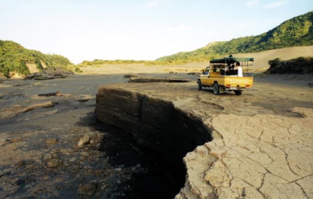 |
Figure 31. Erosion channel at the N end of the ash plain at Yasur caused by draining of Lake Siwi. Courtesy of John Seach. |
Three fumaroles were active on the caldera wall near the parking area at the summit. The crater rim was climbed from the SE and observations made from 1700 to 1930. Yasur showed a high level of activity with up to three vents erupting simultaneously inside the main crater. Eruptions occurred every one or two seconds during the 2.5-hour stay at the summit. Most eruptions were Strombolian with glowing bombs sent up to 150 m above the crater (figure 32). Projectiles generally fell back inside the crater, but the northern-most vent occasionally sent glowing lava bombs over the N and NE crater rims. Mild Vulcanian eruptions occurred at times with ash ejected to 100 m above the crater. Bombs were ejected as either glowing orange blobs of lava or black crusted material. Eruptions were accompanied by loud explosions and ground shaking. Bombs impacting on the ash made a sound like raindrops.
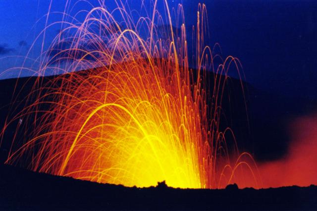 |
Figure 32. Time-lapse night photo of a Strombolian eruption from Yasur (southern vent) on 7 December 2002. Courtesy of John Seach. |
Seismic counts made by the Institute of Research and Development (Noumea) showed an increase in eruptive activity at Yasur in the beginning of December 2002 with Level 3 events increasing from 10 to 40 per hour (see BGVN 27:01 for description of seismic count data). Seismic counts remained elevated until the end of January 2003 when activity reduced to pre-December 2002 levels.
MODVOLC Thermal Alerts, 2001-2002. MODIS alerts occurred only three times in 2001 but increased in frequency, size, and alert ratio during 2002 (figure 33). The alerts that occurred in 2001, on 10 March, 4 April, and 31 August, were characterized by a single alert-pixel with very low alert ratio. Ground reports for this period noted mild eruptive activity, with vigorous Strombolian activity beginning in late December 2001 (BGVN 26:11 and 27:01). From 31 January 2002 MODIS indicates quasi-continuous activity throughout the year, which was at its most intense in the two months beginning 29 August 2002 (2210 local time). This followed the M 6 volcanic earthquake at 1500. A map of alert-pixel coordinates places them consistently E of the crater, but this may be a geolocation error rather than being indicative of a new vent.
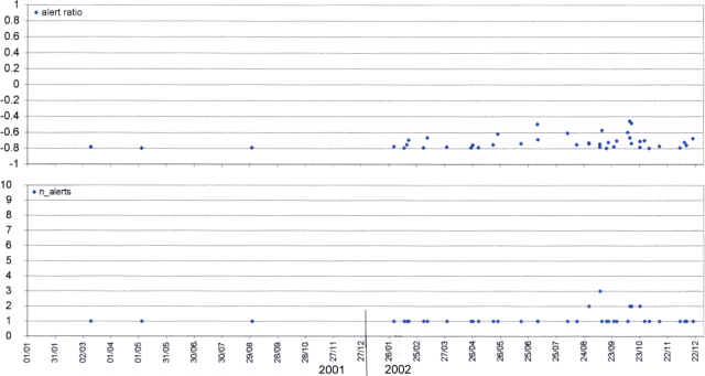 |
Figure 33. MODIS thermal alerts on Yasur during 2001-2002. Courtesy of Diego Coppola and David Rothery, The Open University. |
Geological Summary. Yasur has exhibited essentially continuous Strombolian and Vulcanian activity at least since Captain Cook observed ash eruptions in 1774. This style of activity may have continued for the past 800 years. Located at the SE tip of Tanna Island in Vanuatu, this pyroclastic cone has a nearly circular, 400-m-wide summit crater. The active cone is largely contained within the small Yenkahe caldera, and is the youngest of a group of Holocene volcanic centers constructed over the down-dropped NE flank of the Pleistocene Tukosmeru volcano. The Yenkahe horst is located within the Siwi ring fracture, a 4-km-wide open feature associated with eruption of the andesitic Siwi pyroclastic sequence. Active tectonism along the Yenkahe horst accompanying eruptions has raised Port Resolution harbor more than 20 m during the past century.
Information Contacts: Roberto Carniel, Università di Udine, Italy (URL: http://www.swisseduc.ch/stromboli/); Douglas Charley, Département de la Géologie, des Mines et des Ressources en eau, Vanuatu; Marco Fulle, Osservatorio Astronomico, Trieste, Italy (URL: http://www.swisseduc.ch/stromboli/); Diego Coppola and David A. Rothery, Department of Earth Sciences, The Open University, Milton Keynes, MK7 6AA, United Kingdom; John Seach, PO Box 16, Chatsworth Island, NSW 2469, Australia (URL: http://www.volcanolive.com/); Jeff and Cynthia Gneiser, Zegrahm & Eco Expeditions, 192 Nickerson Street ##200, Seattle, WA 98109, USA (URL: https://www.zegrahm.com/); International Federation of Red Cross and Red Crescent Societies, PO Box 372, CH-1211 Geneva 19, Switzerland (URL: http://www.ifrc.org/); Wellington Volcanic Ash Advisory Center (VAAC), MetService, PO Box 722, Wellington, New Zealand (URL: http://vaac.metservice.com/); Michel Lardy, Institut de Recherche pour le Développement (IRD), CRV, BP A 5 Nouméa, Nouvelle Calédonie; Société Volcanologique Européenne, C.P. 1, 1211 Geneva 17, Switzerland (URL: http://www.sveurop.org/).