Report on Monowai (New Zealand) — February 2003
Bulletin of the Global Volcanism Network, vol. 28, no. 2 (February 2003)
Managing Editor: Edward Venzke.
Monowai (New Zealand) Volcanic earthquake swarm during 1-24 November eruption
Please cite this report as:
Global Volcanism Program, 2003. Report on Monowai (New Zealand) (Venzke, E., ed.). Bulletin of the Global Volcanism Network, 28:2. Smithsonian Institution. https://doi.org/10.5479/si.GVP.BGVN200302-242050
Monowai
New Zealand
25.887°S, 177.188°W; summit elev. -132 m
All times are local (unless otherwise noted)
Numerous eruptions of Monowai Seamount (also known as Orion Seamount), an active volcano located in the Kermadec Island arc, were detected by the Polynesian Seismic Research (Reseau Sismique Polynesien, RSP) seismic network in Tahiti (figure 8). Strong T-phase waves were recorded at all of the stations in the RSP network (figure 9). The last reports of Monowai eruption activities were in January 1998 (BGVN 23:01), June 1999 (BGVN 24:06), and May 2002 (BGVN 27:05).
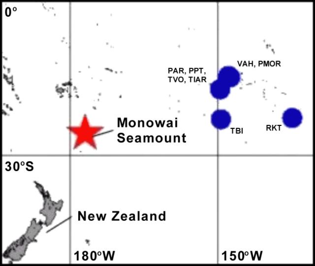 |
Figure 8. Map of the South Pacific Ocean showing the location of some RSP (Reseau Sismique Polynesien) seismic network stations (circles indicate area of island group with labeled stations) and Monowai Seamount (star). All seismic stations are inland; there are no hydrophones in the network. Stations shown include VAH and PMOR (Tuamotu archipelago), PAE, PPT, TVO, and TIAR (Society Islands), TBI (Austral Islands), and RKT (Gambier archipelago). Courtesy of Laboratoire de Geophysique, Tahiti. |
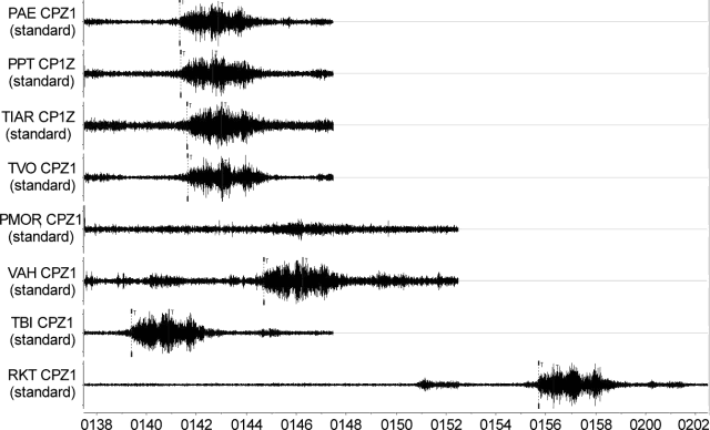 |
Figure 9. Example of strong T-phase waves detected by the RSP from Monowai, 18 November 2002 (times are UTC). All the seismic stations in the network recorded the wave generated during eruption of the volcano. Note the good signal coherency between most stations. The record at the PMOR station, located in the north of Rangiroa, was masked for the T waves. Courtesy of Laboratoire de Geophysique, Tahiti. |
Geophysical network. The Polynesian Seismic Network is composed of short-period seismic stations on Rangiroa atoll in the Tuamotu archipelago (stations VAH and PMOR), on Tahiti in the Society Islands (stations PAE, PPT, TVO, and TIAR), on Tubuai in the Austral Islands (station TBI), and on Rikitea in the Gambier archipelago (station RKT). There are also three long-period seismic stations in Tahiti, Tubuai, and Rikitea. In addition, Comprehensive Test Ban Treaty (CTBT) instruments located in Tahiti include a mini-array of micro-barographs, a primary seismic station (station PS18 at Papeete), and a radionuclide station.
Earthquake swarm. A volcanic earthquake swarm started on 1 November 2002 at 1200 UTC with strong explosive T-phase waves recorded by the RSP network (figure 10). The swarm stopped temporarily between 8 and 17 November; a second, very intense swarm started on 17 November (figure 11) and ended on 24 November. From inversion of T-phase wave arrival times, it was deduced that the swarm was located around Monowai Seamount. Because of the small aperture of the RSP network, the location is poorly constrained in longitude, but well constrained in latitude (figure 12). The source of the T-phase waves is most probably at Monowai.
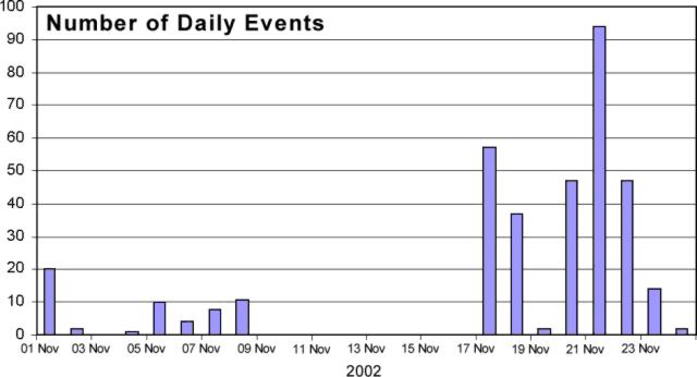 |
Figure 10. Daily history of the Monowai swarm. The maximum number of daily events was on 21 November, but the higher amplitude T-phase waves were detected during 17-19 November. Courtesy of Laboratoire de Geophysique, Tahiti. |
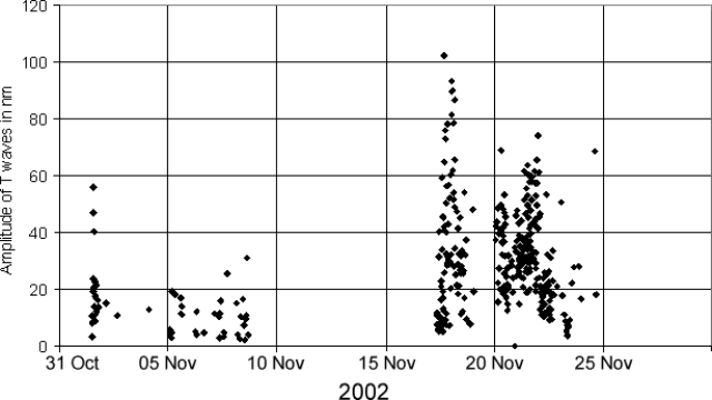 |
Figure 11. Daily history of amplitude (in nanometers) of Monowai swarm T-phase waves recorded at TVO station on Tahiti. The maximum intensity was between 17 and 19 November. These amplitudes should correlate to ground vibrations generated by the volcanic eruptions. Courtesy of Laboratoire de Geophysique, Tahiti. |
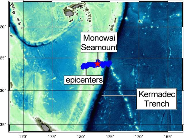 |
Figure 12. Map showing the best source locations of the swarms using the entire seismic network. The star is Monowai Seamount, and the dots are possible source epicenters. The effect of linearity observed on the epicenters is due essentially to the aperture size of the network, but note that the latitude is well constrained. Courtesy of Laboratoire de Geophysique, Tahiti. |
Regarding T-Phase waves. A short-period wave group from a seismic source that has propagated in part through the ocean is called T-phase or T(ertiary)-wave (Linehan, 1940; Tolstoy and Ewing, 1950; Walker and Hammond, 1998). The wave group propagates with low attenuation as hydro-acoustic (compressional) waves in the ocean, constrained within a low sound speed wave guide (the sound fixing and ranging - SOFAR - channel) formed by the sound speed structure in the ocean. The T-phase signal may be picked up by hydrophones in the ocean or by land seismometers. Upon incidence with the continental shelf/slope, the wave group is transformed into ordinary seismic waves that arrive considerably later than seismic wave groups from the same source that propagated entirely through the solid earth.
References. Brothers, R.N., Heming, R.F., Hawke, M.M., and Davey, F.J., 1980, Tholeiitic basalt from the Monowai seamount, Tonga-Kermadec ridge (Note): New Zealand Journal of Geology and Geophysics, v. 23, p. 537-539.
Davey, F.J., 1980, The Monowai Seamount: an active submarine volcanic centre of the Tonga-Kermadec Ridge (Note): New Zealand Journal of Geology and Geophysics, v. 23, p. 533-536.
Linehan, D, 1940, Earthquakes in the West Indian region: Transactions, American Geophysical Union, Pt. II, p. 229-232.
Tolstoy, I., and Ewing, M., 1950, The T phase of shallow-focus earthquakes: Bulletin of the Seismological Society of America, v. 40, p. 25-51.
Walker, D.A., and Hammond, S.R., 1998, Historical Gorda Ridge T-phase swarms; relationships to ridge structure and the tectonic and volcanic state of the ridge during 1964-1966: Deep-Sea Research Part II, v. 45, n. 12, p. 2531-2545.
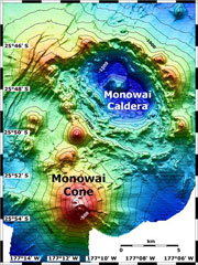
Geological Summary. Monowai, also known as Orion seamount, is a basaltic stratovolcano that rises from a depth of about 1,500 to within 100 m of the ocean surface about halfway between the Kermadec and Tonga island groups, at the southern end of the Tonga Ridge. Small cones occur on the N and W flanks, and an 8.5 x 11 km submarine caldera with a depth of more than 1,500 m lies to the NNE. Numerous eruptions have been identified using submarine acoustic signals since it was first recognized as a volcano in 1977. A shoal that had been reported in 1944 may have been a pumice raft or water disturbance due to degassing. Surface observations have included water discoloration, vigorous gas bubbling, and areas of upwelling water, sometimes accompanied by rumbling noises. It was named for one of the New Zealand Navy bathymetric survey ships that documented its morphology.
Information Contacts: Dominique Reymond and Olivier Hyvernaud, Laboratoire de Geophysique, CEA/DASE/LDG, Tahiti, PO Box 640, Papeete, French Polynesia.