Report on Reventador (Ecuador) — February 2003

Bulletin of the Global Volcanism Network, vol. 28, no. 2 (February 2003)
Managing Editor: Edward Venzke.
Reventador (Ecuador) Ashfall in January, mudflows in February-March; additional data from November
Please cite this report as:
Global Volcanism Program, 2003. Report on Reventador (Ecuador) (Venzke, E., ed.). Bulletin of the Global Volcanism Network, 28:2. Smithsonian Institution. https://doi.org/10.5479/si.GVP.BGVN200302-352010
Reventador
Ecuador
0.077°S, 77.656°W; summit elev. 3562 m
All times are local (unless otherwise noted)
On 3 November 2002, an unexpected eruption occurred at Reventador (BGVN 27:11). The following report provides an update on recent activity and additional information about the November eruption, including discussion of a site visit after the eruption and satellite data.
Recent activity. Seismicity was low during mid-December 2002. On 10 January, Instituto Geofísico (IG) reported that several lahars occurred that day in the Marquer and Reventador rivers. Ashfall was reported in the N sector of Quito, ~90 km to the WSW. In the afternoon a bluish gas column was observed exiting the crater. IG personnel stated that lava was slowly advancing and that 80-90% of the 3 November 2002 pyroclastic-flow deposits were covered by lahars.
During late February, rain generated mudflows that ended near the Montana River and disrupted traffic on a highway. White steam exited the volcano. Seismicity remained low, and was characterized by bands of harmonic tremor and volcano-tectonic (VT) earthquakes.
Intense rains during the first few days of March caused mudflows and again disrupted traffic. A gas column reached 300-500 m above the summit. Low-level seismicity was characterized by bands of harmonic tremor and a few isolated earthquakes. The seismic station in Copete registered high-frequency signals associated with lahars.
Site visit during 17-19 November 2002. The following report of an investigation of the 3 November 2002 explosion (BGVN 27:11) was submitted by Claus Siebe (Instituto Geofísico (IG), UNAM). Siebe, Jesús Manuel Macías, and Aurelio Fernández were able to fly to Quito on 17 November. On 18 November they interviewed Ing. Marcelo Riaño (general manager of the Trans-Equatorian Oil-Pipeline) as well as Patricia Mothes, Minard Hall, and Hugo Yepes (IG).
On 19 November they arrived in El Chaco (~34 km from Reventador) and traveled to the confluences of the Ríos Marker and Montana with the Río Coca (both are located 8 km from the crater). A small apron of fresh lahar deposits ~300 m wide covered the area adjacent to the Río Marker where the road had been before the 3 November eruption. Several dozens of workers with heavy machinery were trying to make a temporary passage over the gravel and boulder surface for the waiting trucks. For a few minutes they could see for the first and only time a ~1-km-high brownish ash column rising from the crater before incoming clouds hindered further visual contact.
"At the time of our visit, the Río Marker was diminished to such an extent that we could jump from boulder to boulder from one side to the other of the stream without getting wet. The vegetation around the confluence of the rivers was completely destroyed, and surviving trees were scorched and defoliated. The base layer of the fresh deposits consisted of up to 2.5-m-thick, partly matrix-supported, partly clast-supported pyroclastic-flow deposit with abundant wood and charcoal fragments (abundant scoriaceous boulder- and gravel-sized clasts were subrounded while dense clasts were angular). This was overlain by a sequence of several sandy-gravelly lahar units with abundant charcoal supporting larger boulders as well as clasts from the underlying pyroclastic-flow deposit.
About 400 m from the Río Marker, after passing a narrow zone of unaffected vegetation, we were able to reach the Río Montana, where a similar situation was encountered (figure 7). Here, at places the lahar deposits were still steaming with a sulfurous smell. The bridge over the river was destroyed, but the oil pipeline was still basically intact (figure 8). Since the area did not seem safe (the last lahar had been emplaced less than 24 hours prior) the team returned to El Chaco, where they interviewed several people and obtained photographs of the pyroclastic flow and its deposits taken on 3 November 2002 (figures 9-11).
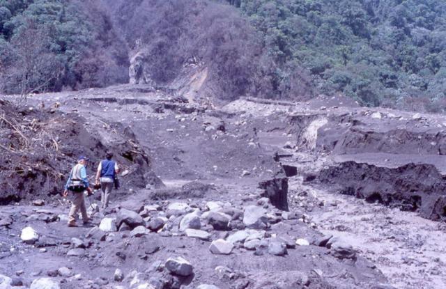 |
Figure 7. Fresh lahar deposits at Reventador near the confluence of Río Montana with Río Coca on 19 November 2002. According to workers trying to repair the road the still-warm and steaming surface of the lahar deposit shown in the photo was produced during the afternoon of 18 November after heavy rain. This was the 10th lahar event since 3 November. Courtesy of Claus Siebe. |
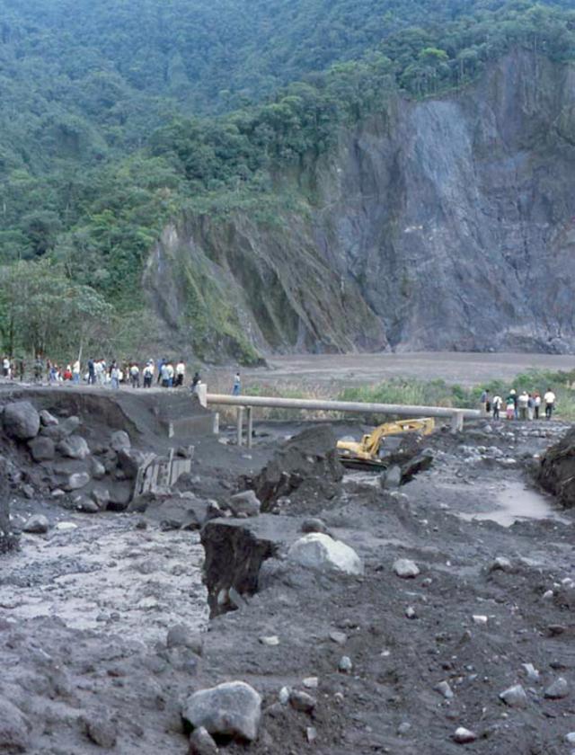 |
Figure 8. Photo looking downstream near the confluence of Río Montana with Río Coca on the ESE flank of Reventador. In the foreground are the fresh lahar deposits. In the middle ground is the destroyed concrete bridge over the Río Montana as well as the oil-pipeline immediately behind. The bulldozer is trying to built a temporary passage for hundreds of trucks waiting on both sides of the road. In the background is the Río Coca with distal-debris avalanche deposit (19,000 Y BP) forming the vegetated hills behind the river. Photo taken on 19 November shortly after 1300 by Claus Siebe. Courtesy of Claus Siebe. |
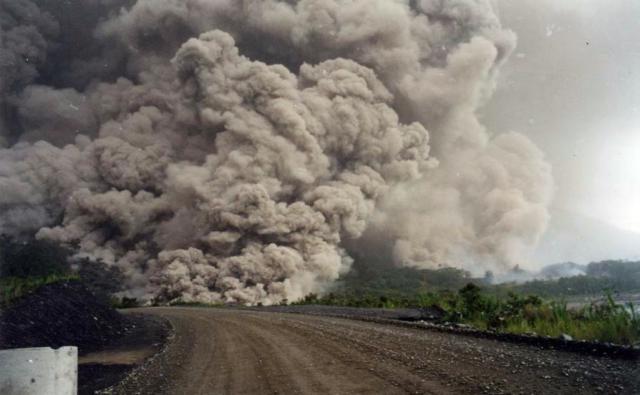 |
Figure 9. Pyroclastic flow descending Reventador's SE slopes during the morning of 3 November 2002. Photo was taken from the E (Transoceanic road in the foreground). This anonymous photo was purchased at a small hotel in El Chaco. Courtesy of Claus Siebe. |
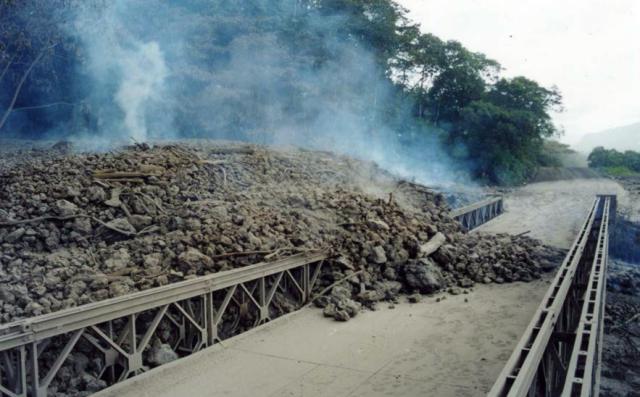 |
Figure 10. Fresh pyroclastic-flow deposits from Reventador, produced on 3 November 2002, ponding against the bridge over the Río Montana. This anonymous photo was purchased at a small hotel in El Chaco. Courtesy of Claus Siebe. |
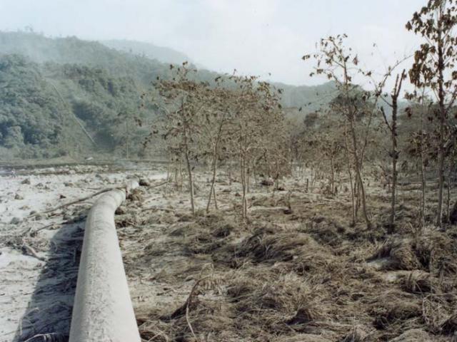 |
Figure 11. Distal pyroclastic-flow deposits from Reventador and scorched vegetation along the Transandean oil-pipeline near the confluence of the Río Montana with the Río Coca. This anonymous photo was purchased at a small hotel in El Chaco. Courtesy of Claus Siebe. |
At about 2200 we drove to the summit of a hill (2,959 m elevation) N of Sta. Rosa, 27.5 km from the summit of Reventador. Although the night was clear and we had a good view, the summit was covered by clouds and no incandescence from an advancing lava flow could be seen.
From conversations with personnel from PETROECUADOR, road workers, peasants, etc., the team obtained the following information. Workers from TECHINT, an Argentinian company building a second pipeline parallel to the existing one, were at their campsite near the Río Montana when the eruption started in the early hours of 3 November (it was still dark). The eruption came without prior warning, but they were able to evacuate before strong explosions around 0900 sent pyroclastic flows along the Ríos Montana and Marker. These flows destroyed the road and parts of the new pipeline still under construction. The old pipeline was displaced several meters horizontally but never broke. At places the pyroclastic-flow deposits came to rest in direct contact with the tube. Temperature measurements at points of contact yielded values of 80°C. In subsequent days several lahars came down the Ríos Montana and Marker after heavy rains, further damaging the road (but not the pipeline). The pipeline has continued its operation; it delivers more than 400,000 barrels of oil per day to the Pacific coast.
Inhabitants of the small village of El Reventador, located ~12 km downstream from the confluence of the Ríos Montana and Coca voluntarily evacuated their homes when they heard the explosions around 0900.
One of the scoriaceous juvenile rock samples collected near the confluence of Río Marker with Río Coca was analyzed by X-ray fluorescence and thin sections were made of the same sample. The results revealed that the rock is an andesite (SiO2= 58.1%) similar in composition to those erupted in 1976 (55-58% SiO2).
Satellite data. Simon Carn (NASA/UMBC) reported that TOMS observations of the Reventador eruption clouds during 3-4 November suggest modest SO2 burdens and spatial separation of the emitted SO2 and ash. Carn, with input from Andy Harris, also constructed a timeline of notable events during 3-6 November along with potentially useful satellite images and overpasses (table 2).
Table 2. Preliminary timeline of the November 2002 eruption of Reventador, compiled using satellite imagery and information from IG and the Washington VAAC. Courtesy of Simon Carn and Andy Harris.
| Date | Time (UTC) | Satellite | Event |
| 3 Nov 2002 | 0700 | -- | Seismic events recorded |
| 3 Nov 2002 | 0945 | GOES-8 | Clear - no hot spot |
| 3 Nov 2002 | 1000 | -- | Eruption begins; 3 km ash column, incandescent ejecta |
| 3 Nov 2002 | 1015, 1045, 1115 | GOES-8 | Clear - no hot spot |
| 3 Nov 2002 | 1245, 1315, 1345 | GOES-8 | Ash |
| 3 Nov 2002 | 1400 | -- | Main eruption phase; pyroclastic flows reported |
| 3 Nov 2002 | 1415 | GOES-8 | Ash, ring-shaped cloud? |
| 3 Nov 2002 | 1445 | GOES-8 | Ash |
| 3 Nov 2002 | 1510 | MODIS Terra | Ash |
| 3 Nov 2002 | 1515 | GOES-8 | Ash |
| 3 Nov 2002 | 1530 | GOME | SO2 |
| 3 Nov 2002 | 1543 | EP TOMS | SO2, ash |
| 3 Nov 2002 | 1545, 1615, 1645 | GOES-8 | Ash |
| 3 Nov 2002 | 1707 | NOAA-16 AVHRR | Ash |
| 3 Nov 2002 | 1715 | GOES-8 | Ash |
| 3 Nov 2002 | 1722 | SeaWiFS | Ash |
| 3 Nov 2002 | 1745 | GOES-8 | Ash |
| 3 Nov 2002 | 1810 | -- | Ash begins to fall in Quito |
| 3 Nov 2002 | 1815, 1845, 1915, 1945 | GOES-8 | Ash |
| 3 Nov 2002 | 2000 | -- | Ash covers large area of Ecuador, reaching coast |
| 3 Nov 2002 | 2015 | GOES-8 | Ash, gravity waves? |
| 3 Nov 2002 | 2045, 2115, 2145, 2215 | GOES-8 | Ash, gravity waves |
| 4 Nov 2002 | 0345, 0415, 0445, 0515, 0545, 0615 | GOES-8 | Cloud-covered |
| 4 Nov 2002 | 0625 | MODIS Aqua | Ash, SO2 |
| 4 Nov 2002 | 0645 | GOES-8 | Cloud clearing- possible hot spot |
| 4 Nov 2002 | 0710 | NOAA-16 AVHRR | Ash |
| 4 Nov 2002 | 0715, 0745 | GOES-8 | Hot spot |
| 4 Nov 2002 | 0815, 0845 | GOES-8 | Strong hot spot and plume |
| 4 Nov 2002 | 0915 | GOES-8 | Strong hot spot and minor plume |
| 4 Nov 2002 | 0945, 1015 | GOES-8 | Strong hot and detached minor plume |
| 4 Nov 2002 | 1045 | GOES-8 | Hot spot |
| 4 Nov 2002 | 1115 | GOES-8 | Ash, strong hot spot and main plume |
| 4 Nov 2002 | 1145, 1215, 1245, 1315, 1345, 1415 | GOES-8 | Ash, main plume extends W |
| 4 Nov 2002 | 1445 | GOES-8 | Ash, main plume (N arm) reaches coast |
| 4 Nov 2002 | 1515 | GOES-8 | Ash |
| 4 Nov 2002 | 1530 | GOME | SO2 |
| 4 Nov 2002 | 1555 | MODIS Terra | SO2 |
| 4 Nov 2002 | 1632 | EP TOMS | SO2, ash |
| 4 Nov 2002 | 1715 | GOES-8 | Plume still attached to hot spot |
| 4 Nov 2002 | 1835 | NOAA-16 AVHRR | Ash |
| 4 Nov 2002 | 1845 | MODIS Aqua | SO2 |
| 5 Nov 2002 | 1645, 1715, 1745 | GOES-8 | Low-level ash |
| 5 Nov 2002 | 1815, 1845, 1915 | GOES-8 | Low-level ash |
| 6 Nov 2002 | 1530 | GOME | SO2 |
| 6 Nov 2002 | 1544, 1634, 1545, 1634, 1546 | EP TOMS | SO2 |
The TOMS overpass at 1543 UTC on 3 November captured the early phase of the eruption. An ash signal was localized over the volcano and a more extensive SO2 cloud containing ~12 kilotons SO2 was spreading E and W.
At 1632 UTC on 4 November, TOMS detected several distinct cloud masses. A cloud containing no detectable ash and ~11 kilotons SO2 was situated E of Ecuador on the Perú/Colombia border, a maximum distance of ~600 km from Reventador beyond which a data gap intervened. A second cloud containing ~42 kilotons SO2 and a weak ash signal was observed over the Pacific Ocean around 700 km from the volcano. The highest ash concentrations were detected in a cloud straddling the coast of Ecuador ~260 km W of the volcano that covered ~70,000 km2. This cloud contained little SO2. It is assumed that these clouds (total ~53 kilotons SO2) were erupted on 3 November.
A plume was also detected extending ~200 km W of Reventador, containing ~10 kilotons SO2. Based on high temporal resolution GOES imagery this plume first appeared sometime between 1045 UTC and 1115 UTC on 4 November. Nearby Guagua Pichincha was also reported active at this time by the Washington VAAC, and may have contributed some SO2; the highest SO2 concentrations in the Reventador plume were measured in the TOMS pixel covering Guagua Pichincha.
On 5 November neither SO2 nor ash were detected by TOMS, although a ~700-km-wide data gap occurred off the coast of Ecuador. The TOMS orbit was better placed on 6 November but no SO2 or ash were apparent. However, renewed SO2 emissions were detected on 7 November.
Geological Summary. Volcán El Reventador is the most frequently active of a chain of Ecuadorian volcanoes in the Cordillera Real, well east of the principal volcanic axis. The forested, dominantly andesitic stratovolcano has 4-km-wide avalanche scarp open to the E formed by edifice collapse. A young, unvegetated, cone rises from the amphitheater floor to a height comparable to the rim. It has been the source of numerous lava flows as well as explosive eruptions visible from Quito, about 90 km ESE. Frequent lahars in this region of heavy rainfall have left extensive deposits on the scarp slope. The largest recorded eruption took place in 2002, producing a 17-km-high eruption column, pyroclastic flows that traveled up to 8 km, and lava flows from summit and flank vents.
Information Contacts: P. Ramon, M. Hall, P. Mothes, and H. Yepes, Instituto Geofísico (IG), Escuela Politécnica Nacional, Quito (URL: http://www.igepn.edu.ec/); Simon A. Carn, Joint Center for Earth Systems Technology (NASA/UMBC), University of Maryland-Baltimore County, 1000 Hilltop Circle, Baltimore, MD (URL: https://jcet.umbc.edu/); Andy Harris, HIGP/SOEST, University of Hawaii at Manoa, HI 96822 USA (URL: http://goes.higp.hawaii.edu/); Claus Siebe and Gabriel Valdez Moreno, Instituto de Geofísica, UNAM, Mexico, D.F.; Jesús Manuel Macías, CIESAS-Mexico, Juarez 87, Tlalpan, DF. CP14000; Aurelio Fernández Fuentes, Centro Universitario de Prevencion de Desastres, Universidad de Puebla, Mexico; Washington Volcanic Ash Advisory Center (VAAC), Satellite Analysis Branch (SAB), NOAA/NESDIS E/SP23, NOAA Science Center Room 401, 5200 Auth Road, Camp Springs, MD 20746, USA (URL: http://www.ospo.noaa.gov/Products/atmosphere/vaac/).