Report on Nyiragongo (DR Congo) — August 2003

Bulletin of the Global Volcanism Network, vol. 28, no. 8 (August 2003)
Managing Editor: Edward Venzke.
Nyiragongo (DR Congo) Continued lava lake activity during May-June; ashfall in local villages
Please cite this report as:
Global Volcanism Program, 2003. Report on Nyiragongo (DR Congo) (Venzke, E., ed.). Bulletin of the Global Volcanism Network, 28:8. Smithsonian Institution. https://doi.org/10.5479/si.GVP.BGVN200308-223030
Nyiragongo
DR Congo
1.52°S, 29.25°E; summit elev. 3470 m
All times are local (unless otherwise noted)
Reports from the staff of the Goma Volcano Observatory (GVO) during May to 5 July 2003 noted that the hazard status remained at Yellow ("Vigilance"). Seismicity was characterized by tectonic, long-period, and short-period earthquakes. Deformation across the majority of fractures lacked significant extensional displacements, but the fractures in the S of Shaheru had compressional displacements. In spite of significant crater activity, geochemical and deformation measurements did not suggest any danger to the inhabited zones on the S flank.
During 4-24 May there was ashfall at Kibati (below 2,000 m on the SSE flank, ~8 km from the summit), Rusayo (~8 km from the summit on the SW flank), and Goma (~18 km S). Nightly red glows and degassing were observed each day. Crater observations revealed two pits containing lava fountains, with a NE-SW lengthening of the principal pit. An active lava flow was observed on 7 May inside the crater. During 18-24 May volcanic ash, including Pele's hair, continued to fall in villages around the volcano, including Goma. During 8-28 June the lava lake continued to emit a gas-and-ash plume. The lake was ~700 m below the edge of the crater. Collapses in the crater were observed during 13-14 and 18-20 June.
Seismicity. During 4-24 May 2003, seismic activity was dominated by persistent volcanic tremor. During 4-10 May, only two long-period earthquakes and a short-period fracture earthquake were recorded, although during 11-17 May an increased number of long-period earthquakes were distributed on the N flank along the fracture trending from Nyiragongo to Nyamuragira. A small number of short-period earthquakes occurred to the WSW along the Nyiragongo-Sake axis (Sake is ~24 km NW of Goma). During 18-24 May long-period earthquakes continued to appear in the NE-SE direction; some isolated long-period events were observed ENE towards Kibumba.
During 8-21 June persistent tremor continued, and six long-period earthquakes were reported. These tremors suggested intense activity in the crater. Weaker seismicity during the following week, 22-28 June, remained dominated by tremors caused by lava lake activity.
All earthquakes were recorded at the Kibumba, Rusayo, and Bulengo seismic stations and occurred at depths of 0-27 km, with an aseismic zone at 3-7 km.
Deformation and temperature. During 4-10 May 2003, measurements of deformation along the cracks in the S flank indicated neither contraction nor extension when compared with the previous week. During the next two weeks, no deformation occurred along the cracks at numerous other S-flank sites.
Contraction during 8-14 June along the Shaheru fractures (~2 km S of the crater) was 8 mm in Lower Shaheru and 29 mm in Higher Shaheru, suggesting that magma in the fractures S of Nyiragongo had not moved. During 15-21 June, temperature measurements in fractures at Nyiragongo, Shaheru, and Monigi (~1.5 km NE of the Goma airport) varied less than those measured in April-May. Average temperatures were in the range of 14.6-63.1°C.
During 22-28 June deformation measurements of fractures did not reveal any notable variation compared to previous measurements at Monigi, Mugara, and Nyiragongo Cants. Temperatures measured in the Monigi and Lemera fractures did not vary, while those at Mugara showed a slight increase of 3.6°C between 21 May and 28 June.
Crater observations, 22-23 May 2003. Kasereka and Yalire (GVO) remained at the summit of Nyiragongo during 22-23 May. During their SSE-flank ascent, vegetation was covered with slag and ash from Kibati (2,000 m) to the summit (3,470 m). Two types of Pele's hair were observed: those with a length of 20-40 cm were present from Shaheru (2,200 m) to the huts (3,250 m), and those shorter than 15 cm were present from the huts to the summit.
Upon arrival at the summit they observed a gas plume that covered the entire crater. The crater could only be seen for a few seconds at a time. However, the bottom of the crater was entirely occupied by the lava lake, and not by separate lava-filled pits; the crater bottom had an elliptical form elongated in a NE-SW direction. This lava lake was, when calm, characterized by undulatory movements of low amplitude, and, when agitated, projected materials 40-60 m high. A collapse in the crater was not recorded by the seismic network. For three hours that evening there were explosions in the crater, followed by ashfall on the summit.
For one hour on the morning of 23 May there was a total lull, with no growls or explosions, that corresponded to a decline of volcanic tremor recorded at the Bulengo, Kibumba, and Rusayo stations. The atmosphere immediately above the crater then cleared for at least 10 minutes, and photos were taken of the crater floor showing the single lava lake at the bottom of the crater (figure 31). Measurements could not be taken of the depth of the lava lake surface because the atmosphere was clouded by the gas plume. Analyses by the GVO showed that the pH of rainwater from the air was 4.13 and its conductivity was 2.08 ms/cm.
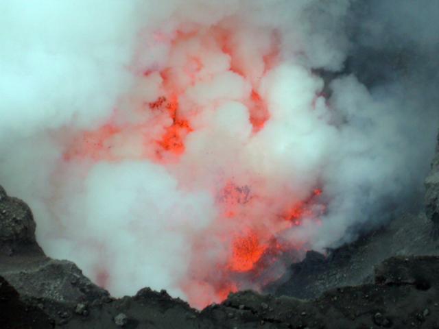 |
Figure 31. Photograph of the lava lake (seen through the gas plume) occupying the bottom of the Nyiragongo crater, 23 May 2003. Courtesy of the Goma Volcano Observatory. |
Geological Summary. The Nyiragongo stratovolcano contained a lava lake in its deep summit crater that was active for half a century before draining catastrophically through its outer flanks in 1977. The steep slopes contrast to the low profile of its neighboring shield volcano, Nyamuragira. Benches in the steep-walled, 1.2-km-wide summit crater mark levels of former lava lakes, which have been observed since the late-19th century. Two older stratovolcanoes, Baruta and Shaheru, are partially overlapped by Nyiragongo on the north and south. About 100 cones are located primarily along radial fissures south of Shaheru, east of the summit, and along a NE-SW zone extending as far as Lake Kivu. Many cones are buried by voluminous lava flows that extend long distances down the flanks, which is characterized by the eruption of foiditic rocks. The extremely fluid 1977 lava flows caused many fatalities, as did lava flows that inundated portions of the major city of Goma in January 2002.
Information Contacts: Goma Volcano Observatory, Departement de Geophysique, Centre de Recherche en Sciences Naturelles, Lwiro, D.S. Bukavu, DR Congo.