Report on Momotombo (Nicaragua) — September 2003
Bulletin of the Global Volcanism Network, vol. 28, no. 9 (September 2003)
Managing Editor: Edward Venzke.
Momotombo (Nicaragua) Some seismic swarms and tornillos; stable fumarole temperatures
Please cite this report as:
Global Volcanism Program, 2003. Report on Momotombo (Nicaragua) (Venzke, E., ed.). Bulletin of the Global Volcanism Network, 28:9. Smithsonian Institution. https://doi.org/10.5479/si.GVP.BGVN200309-344090
Momotombo
Nicaragua
12.423°N, 86.539°W; summit elev. 1270 m
All times are local (unless otherwise noted)
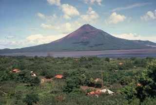
Instituto Nicaraguense de Estudios Territoriales (INETER) reports from March 2002 through September 2003 indicate that seismicity has generally been low. Occasional visits to the summit of Momotombo (figure 10) are made to sample gases and take temperature measurements.
 |
Figure 10. Photograph of Momotombo (unknown date) showing the E flank and the 1905 lava flows. Note that a small steam plume is rising from the crater fumaroles. Lake Managua is in the background. Courtesy of INETER. |
The first visit during this time period was on 13 April 2002. Temperature measurements in the crater fumaroles showed little variation from previous measurements, except for fumarole 14, which showed an increase from 434 to 583°C. There were no visits in May; seismic monitoring recorded only one earthquake.
Seismicity increased during the early part of June, with a seismic cluster from 1 to 11 June SW of Momotombo consisting of more than 120 earthquakes. Thirty of these earthquakes occurred on 9 June. An event on 8 June was felt at the geothermal plant W of the volcano. The majority of these events were volcano-tectonic earthquakes with frequencies between 15 and 20 Hz. The unusual tornillos (screw-type events) have continued to occur at Momotombo, usually lasting 2-5 seconds with a dominant frequency of 5 Hz.
Only 16 earthquakes were recorded in July, four of them on 12 July; none were located. Tornillos continued with a frequency of 7.5 Hz in both July and August. Seismicity increased in August with a small seismic cluster and 176 registered earthquakes, mainly volcano-tectonic. The majority of the activity took place on 1 and 2 August, including one event felt by staff at the geothermal plant. Seismicity dropped dramatically in September, October, and November, with 7 and 12 volcano-tectonic events in September and October, respectively, and none in November. Visits were made on 19, 20, 21, and 22 November for gas sampling and temperature measurements. Temperatures were measured in 12 fumaroles and around the seismic stations at the base of the volcano. The highest temperatures were found at fumaroles 3, 4, 5, 8, and 9, with the maximum temperature of 768°C at fumarole 9. Temperatures at the three fumaroles around the seismic station were 89.9°C, 99.1°C, and 90.2°C.
Seismicity increased again in December 2002 and January 2003. A seismic cluster of 88 events was recorded during 24-25 December. Locations determined for 18 of the events put them all very close to the volcano. In January 55 tectonic earthquakes were registered. After January, seismicity dropped considerably. No earthquakes were registered in February, and only one was recorded in March.
Site visits in February included walking around the crater; no morphological changes were observed. The visit also included gas sampling and temperature measurements. Fumaroles 8 and 9 measured 759°C and 762°C, respectively; more monitoring on 8 and 27 March showed that temperatures were staying relatively constant. No visits were made in April, May, or June, but seismic monitoring continued. Although only one volcano-tectonic earthquake registered in April, tornillos continued, with frequencies above 12 Hz. There were 35 volcano-tectonic events in May, including a three-hour-long cluster on 30 May. Six seismic events registered in June.
A visit was made to the volcano on 12 July 2003; temperatures were similar to the previous months, ranging from 243°C at fumarole 13 to 737°C at fumarole 9. Two earthquakes registered in August; seismicity stayed low through September.
Geological Summary. Momotombo is a young stratovolcano that rises prominently above the NW shore of Lake Managua, forming one of Nicaragua's most familiar landmarks. Momotombo began growing about 4500 years ago at the SE end of the Marrabios Range and consists of a somma from an older edifice that is surmounted by a symmetrical younger cone with a 150 x 250 m wide summit crater. Young lava flows extend down the NW flank into the 4-km-wide Monte Galán caldera. The youthful cone of Momotombito forms an island offshore in Lake Managua. Momotombo has a long record of Strombolian eruptions, punctuated by occasional stronger explosive activity. The latest eruption, in 1905, produced a lava flow that traveled from the summit to the lower NE base. A small black plume was seen above the crater after a 10 April 1996 earthquake, but later observations noted no significant changes in the crater. A major geothermal field is located on the south flank.
Information Contacts: Martha Navarro, Emilio Talavera, and Virginia Tenorio, Instituto Nicaraguense de Estudios Territoriales (INETER), Dirección General de Geofísica, Apartado Postal 2110, Managua, Nicaragua (URL: http://www.ineter.gob.ni/).