Report on Dukono (Indonesia) — November 2003

Bulletin of the Global Volcanism Network, vol. 28, no. 11 (November 2003)
Managing Editor: Edward Venzke.
Dukono (Indonesia) Nearly continuous explosions, long ash plumes, and local ashfall
Please cite this report as:
Global Volcanism Program, 2003. Report on Dukono (Indonesia) (Venzke, E., ed.). Bulletin of the Global Volcanism Network, 28:11. Smithsonian Institution. https://doi.org/10.5479/si.GVP.BGVN200311-268010
Dukono
Indonesia
1.6992°N, 127.8783°E; summit elev. 1273 m
All times are local (unless otherwise noted)
Ash explosions during 29 September-19 October rose 50-100 m above the crater. Some of the explosions were accompanied by blasting sounds, and ash fell to the E around the Tobelo area. White-gray ash eruptions continued during 27 October-30 November accompanied by booming sounds, a 100-m-high gray ash column, and more ashfall in the Tobelo area. The hazard status remained at Alert Level 2 (on a scale of 1-4) throughout this period.
The monitoring effort by the Volcanological Survey of Indonesia has been affected by the civil unrest on Halmahera. By 19 November the Dukono observatory had been completely destroyed by the recent "riots," with no idea when it might be rebuilt. Officially there is no longer a VSI officer there, but sometimes two staff check on the volcano. On 18 November they called Bandung with news that activity had increased, with larger, more frequent eruptions (every 5-15 minutes) generating higher plumes. Over the few weeks prior to 18 November eruptive activity has been tending towards bigger explosions, sometimes producing pyroclastic falls and lava flows down to the beach.
Ash plumes from Dukono have been identified in satellite imagery by the Darwin Volcanic Ash Advisory Centre almost every week since early June 2003. Plumes were usually reported rising to altitudes of 3-4.5 km and extending downwind 45-75 km from the summit. Longer plumes to distances of 80-130 km were reported after 18 August. Distinct visual plumes reaching distances of over 200 km were seen in November (figure 2), with a maximum of ~300 km during 12-18 November. Aviation notices continued to be issued through December, warning of almost continuous activity and plumes extending ~90 km from the volcano.
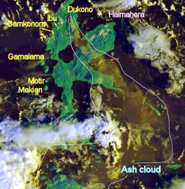 |
Figure 2. Satellite image showing an ash plume extending S and SE from Dukono on 17 November 2003. The volcano is located below the "D" in Dukono, and the approximate extent of the ash cloud has been outlined. Courtesy of Darwin VAAC. |
Paul Taylor provided the following account from Baptist missionary Charles W. Cole. He also noted that the Tobelo "o dukono" just means "(the) volcano," but that the word is now used as a proper name for the volcano on Halmahera. On 16 November 2003 Cole wrote: "The situation in Tobelo continues to be on edge as unknown parties continue to explode bombs. After the distribution of the food packets in Ternate, Kenneth and Oky accompanied the Tobelo pastors on a seven hour ride in a small van to Tobelo. When they arrived in Tobelo it looked like it had just snowed. The ground and all the buildings were covered with white ash. This past week it has rumbled and put out large clouds of white ash. Entire villages and neighborhoods have been destroyed (not by ash)."
Geological Summary. The Dukono complex in northern Halmahera is on an edifice with a broad, low profile containing multiple peaks and overlapping craters. Almost continuous explosive eruptions, sometimes accompanied by lava flows, have occurred since 1933. During a major eruption in 1550 CE, a lava flow filled in the strait between Halmahera and the Gunung Mamuya cone, 10 km NE. Malupang Wariang, 1 km SW of the summit crater complex, contains a 700 x 570 m crater that has also had reported eruptions.
Information Contacts: Dali Ahmad, Hetty Triastuty, Nia Haerani, and Suswati, Volcanological Survey of Indonesia (VSI), Jalan Diponegoro No. 57, Bandung 40122, Indonesia (URL: http://www.vsi.esdm.go.id/); Charles W. Cole, Jakarta, Indonesia; Paul W. Taylor, Australian Volcanological Investigations, PO Box 291, Pymble, NSW 2073, Australia; Andrew Tupper, Darwin Volcanic Ash Advisory Centre (VAAC), Commonwealth Bureau of Meteorology, Northern Territory Regional Office, PO Box 40050, Casuarina, NT 0811, Australia (URL: http://www.bom.gov.au/info/vaac/).