Report on Kavachi (Solomon Islands) — January 2004
Bulletin of the Global Volcanism Network, vol. 29, no. 1 (January 2004)
Managing Editor: Richard Wunderman.
Kavachi (Solomon Islands) Ongoing submarine eruptions; shifting summit elevations; bathymetry
Please cite this report as:
Global Volcanism Program, 2004. Report on Kavachi (Solomon Islands) (Wunderman, R., ed.). Bulletin of the Global Volcanism Network, 29:1. Smithsonian Institution. https://doi.org/10.5479/si.GVP.BGVN200401-255060
Kavachi
Solomon Islands
8.991°S, 157.979°E; summit elev. -20 m
All times are local (unless otherwise noted)
This report covers activity at Kavachi submarine volcano since the eruptions in August to mid-September 2001 and on 27 November 2001 (BGVN 26:11). It includes information from Corey Howell of The Wilderness Lodge on the island of Gatokae (Nggatokae), ~ 35 km NE of Kavachi, and a research cruise of the Commonwealth Scientific and Industrial Research Organization (CSIRO) (McConachy and others, 2002).
On his visit to the site of the volcano on 25 November 2001, Howell described a colored stain in the seawater. His photo of the setting portrays a calm sea surface without visible agitation and very little froth floating on the surface; the stain rose from depth. Elsewhere on his website he commented about trolling and catching fish within upwelled material on this date: "Trolling around the vent at Kavachi delivered the goods once again with 23 large rainbow runner, two Spaniards, [bara]cuda, and bigeye trevally-112 kilos [kg] of fish, which fed the entire village. We dropped two very large Spaniards, both taking the lure right in the middle of the vent upwelling, and saw countless sharks, runner, trevally, and yellowfin."
Howell noted that explosive eruptions occurred daily during 27 November-13 December 2001. Strong monsoon winds prevented visits then. In discussing regional weather patterns he noted that the prevailing monsoon westerly winds common at Kavachi from December to March reach 15-18 knots, increasing to 25-30 knots during torrential rain squalls. Conditions become choppy with seas 1-2 m with an underlying 2-3 m SW groundswell. Seas such as these could influence erosion at Kavachi.
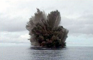
Howell visited Kavachi again on 14 and 28 January 2002, and he passed some 15 km from Kavachi on 17 January 2002. In his summary of those observations and visits, written on 30 January 2002, Howell noted that he had measured the summit's current depth at 60 m. He saw a continuous stream of sulfur, small fragments of volcanic rock, and gases escape, resulting in a vigorous dirty-yellow to light-brown upwelling at the surface. Columns of bubbles rose to the surface and slicks of sulfur prevailed down-current, forming an extensive plume of discolored water several kilometers in length. Occasional explosive eruptions produced columns composed of and occasionally ash, rock, and water, rising to a height of ~ 1 km and visible for at least 40 km.
He went on to say that the vent had emitted a range of loud sonic cracks and booms at intervals of 2-15 minutes. These sounds were loud and clear to witnesses standing in the boat but were heard best in the water, leading to "a sensation that can only be described as being shot point-blank with a high-powered rifle sans pain." Below 10 m water depth divers heard a continual barrage of different sounds coming from the vent. Several powerful earthquakes were felt on nearby Gatokae Island during this observation period (November 2001-January 2002); however, the large regional earthquake that struck Port Vila, Vanuatu, was not felt on the island. When Howell visited Kavachi on 14 January he noted a slick of unidentified materials coming from the vent column. On 28 January he saw extensive trails of yellow sulfur extending down current.
CSIRO conducted two echo-sounding bathymetric surveys of Kavachi a bit over 22 months apart, enabling morphologic comparisons. The earlier survey took place on 14 May 2000 (research cruise FR04/00, Project SHAARC; McInnes and others, 2000) (see BGVN 25:04). The later survey occurred on 28 March 2002 (research cruise FR03/2002, Project SOLAVENTS 2002; McConachy and others, 2002).
Comparing the 2000 to the 2002 bathymetry (figure 7, top and bottom) showed that Kavachi had changed, in places significantly. In 2002 the summit had dropped to clearly well below sea level, compared with 3 m below in 2000. Some lower parts of the volcano appeared to be at lesser depths, perhaps due to mass wasting carrying material downslope and depositing it there. The CSIRO 2002 cruise kept some distance from the summit area, and the shallowest point surveyed was just E of the summit at 85 m depth. Neither of the cruises crossed over the apex of the Kavachi summit.
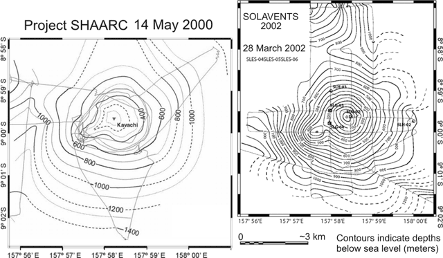 |
Figure 7. Bathymetric maps of Kavachi made by the CSIRO Project SHAARC cruise on 14 May 2000 (left) and the CSIRO Project SOLAVENTS cruise on 28 March 2002 (right). For both maps the fine lines represent ship's tracks during echo soundings. Contour intervals on the SHAARC map are 100 m, for the SOLAVENTS map, 50 m. The SOLAVENTS map shows locations of hydrocast samples (SLH) and bottom grab samples (SLG). Courtesy of Tim McConachy, CSIRO. |
During the CSIRO 2002 cruise an unusual rise in the surface seawater temperature was recorded NW of the summit area and scum resembling oil slicks was noted on the surface in places. Methane analyses of water collected through hydrocasts (a technique where sample bottles are lowered by a cable) suggest hydrothermal sources on the flanks of Kavachi. A bottom grab sample taken at 95 m depth just E of the summit gave off a pungent hydrogen sulfide odor; the black volcanic sand recovered contained small specks (up to pea size) of yellow sulfur and traces of pyrite. A second grab sample, collected NW of the summit, contained gravel-size pieces of more altered, gray to cream colored rock as well as black volcanic sand and gravel. A third grab sample SW of the summit contained black volcanic sand and gravel, but no evidence of native sulfur or sulfide.
About a fortnight after their 28 March 2002 visit, the crew received an email from Howell (dated 18 April 2002), in which he noted that observers on the weather coast of Gatokae (the island's SW side, which faces toward Kavachi) reported eruptions each day that week except Monday. The eruptions usually occurred only once or twice in a 24-hour period.
Howell visited Kavachi again on 16 March 2002, finding the summit then at a depth of 34 m. He determined the summit's coordinates using a Garmin GPS (global positioning system) with a nominal accuracy of ~ 9 m. When this position was plotted on the map generated by the CSIRO 2002 cruise and contoured, Kavachi appeared quite conical in shape with a prominent SW ridge defined by the 350 m contour. Howell's work placed the new summit ~ 315 m E of its previous location (fixing it at 8°59.64'S, 157°58.409'E; whereas the 2000 SHAARC research cruise fixed it at 8°59.65'S, 157°58.23'E).
According to Howell, during October to November 2002 Kavachi ultimately rose to form an island 10-15 m above sea level. In accord with this emergence from the sea, Wright and others (in press) noted four alerts in the MODIS-MODVOLC satellite thermal detection system during November 2002. Howell stated that subsequently the island eroded in late-season SE seas and swells. When visited on 16 November 2003, Howell found the summit at ~ 32 m below sea level, a significant change from the island seen three months earlier.
In summary, table 2 shows discontinuous observations of elevation/depth of the summit of Kavachi over a period of about 3.5 years (2000-2003).
Table 2. A compilation listing the stated elevations (+) and depths (-) of Kavachi's summit over a 3.5-year period. Courtesy of Tim McConachy (CSIRO) and Corey Howell (The Wilderness Lodge).
| Date | Summit depth / elevation | Source |
| 14 May 2000 | -2 to -5 m | CSIRO |
| 28 Jan 2002 | -60 m | Howell |
| 16 Mar 2002 | -34 m | Howell |
| 28 Mar 2002 | Well below sea level | CSIRO |
| Oct/Nov 2002 | +10 m | Howell |
| ~Aug 2003 | +15 m | Howell |
| 16 Nov 2003 | -32 m | Howell |
References. McConachy, T.F., Yeats, C.J., Arculus, R.J., Beattie, R., Belford, S., Holden, J., Kim, J., MacDonald, L., Schardt, C., Sestak, S., Stevens, B., and Tolia, D. (edited by C.J. Yeats), 2002, SOLAVENTS-2002, Solomons Australia Vents Expedition aboard the RV Franklin, 26 March-21 April 2002: CSIRO Exploration and Mining Report 1026F, Final Cruise Report FR03-2002, 456 p.
Peterson, M.G., Wallace, S., and Tolia, D., 1999, Records of explosive Surseyan eruptions from Kavachi, Solomon Islands, in 1961, 1970, 1976, 1978, 1991, 1998, and 1999, Keith, A.W.C., and Rodda, P., eds.: Abstracts of Papers Presented at the STAR (Science, Technology and Resources) Network, SOPAC Miscellaneous Report 355, p. 53.
McInnes, B.I.A., Arculus, R., Massoth, G., Baker, E., Chadwick, J., DeRonde, C., McConachy, T., Posai, P., and Qopoto, C., 2000, Project SHAARC, Investigation of submarine, hydrothermally active arc volcanoes in the Tabar-Lihir-Tanga-Feni Island and Solomon Island chains: CSIRO Exploration and Mining Open File Report 762F, 20 p.
Wright, R., Flynn, L.P., Garbeil, H., Harris, A.J.L., and Pilger, E., (in press), MODVOLC: near-real-time thermal monitoring of global volcanism, Journal of Volcanology and Geothermal Research, Elsevier (2004)
Geological Summary. Named for a sea-god of the Gatokae and Vangunu peoples, Kavachi is located in the Solomon Islands south of Vangunu Island. Sometimes referred to as Rejo te Kvachi ("Kavachi's Oven"), this shallow submarine basaltic-to-andesitic volcano has produced ephemeral islands up to 1 km long many times since its first recorded eruption during 1939. Residents of the nearby islands of Vanguna and Nggatokae (Gatokae) reported "fire on the water" prior to 1939, a possible reference to earlier eruptions. The roughly conical edifice rises from water depths of 1.1-1.2 km on the north and greater depths to the SE. Frequent shallow submarine and occasional subaerial eruptions produce phreatomagmatic explosions that eject steam, ash, and incandescent bombs. On a number of occasions lava flows were observed on the ephemeral islands.
Information Contacts: Timothy F. McConachy, CSIRO Division of Exploration and Mining, P.O. Box 136, North Ryde, NSW 1670, Australia; Corey Howell, The Wilderness Lodge, P.O. Box 206, Honiara, Solomon Islands (URL: http://www.thewildernesslodge.org/).