Report on Tungurahua (Ecuador) — January 2004

Bulletin of the Global Volcanism Network, vol. 29, no. 1 (January 2004)
Managing Editor: Richard Wunderman.
Tungurahua (Ecuador) Frequent ash plumes, prompting occasional ash falls through January 2004
Please cite this report as:
Global Volcanism Program, 2004. Report on Tungurahua (Ecuador) (Wunderman, R., ed.). Bulletin of the Global Volcanism Network, 29:1. Smithsonian Institution. https://doi.org/10.5479/si.GVP.BGVN200401-352080
Tungurahua
Ecuador
1.467°S, 78.442°W; summit elev. 5023 m
All times are local (unless otherwise noted)
A comprehensive summary of activity at Tungurahua (figure 22) over the period January-16 December 2003 was reported in BGVN 28:11. During 17-23 December, volcanic activity continued at relatively high levels, with 5-19 moderate explosions and 62-83 long-period earthquakes each day. A signal from a lahar was recorded in the Cusúa sector NW of the volcano during the afternoon of 18 December. According to the Washington VAAC, during late 2003-early 2004, plumes from Tungurahua were visible on satellite imagery to a maximum altitude of ~ 7.5 km.
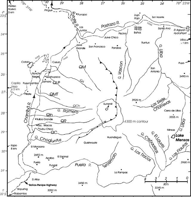 |
Figure 22. A map of Tungurahua emphasizing local roads, settlements, and drainages (quebradas in Spanish). Some of the latter are abbreviated as follows (counterclockwise from N): QA = Quebrada Achupashal, QC = Quebrada Confesionario, QM = Quebrada Mandur, QMT = Quebrada Motilones, QLP = Quebrada La Piramide, QPU = Quebrada Palma Urcu, QR = Quebrada Rea. The map is a composite of various published maps, particularly those by Hall and others in a previously referenced publication. The one contour shown, at 4,300 m elevation on the upper flanks, was the approximate limit of glacial ice when the 1:25,000 Tungurahua topographic map sheet was made for the Instituto Geográfico Militar in 1984. At the time of this report Pete Hall noted that remaining glacial ice was only apparent in restricted regions near the summit crater. |
During 24-30 December the volcano emitted gas, and ash accompanied by low seismicity. On 28 December an emission sent a plume to 1.5 km above the summit, drifting E and NE. Ash fell in the Runtún sector E of the volcano. Emissions on 28 December deposited ash in Runtún and the city of Baños. On 30 December aircraft personnel reported seeing an ash cloud ~ 800 m above the volcano. According to the Washington VAAC, ash was visible on satellite imagery to a maximum altitude of ~ 8 km.
Emissions of gas, and ash, with low-level seismicity (12-14 long-period earthquakes per day), continued over the period 31 December to 5 January. Plumes rose to a maximum height of 3 km above the crater on 31 December and an emission on 4 January caused minor ash fall in the Puela sector (SW). Similar conditions applied in the week 7-13 January. On 8 January, emissions reached ~ 1 km above the volcano, traveling W and SW, and emissions on 12 January deposited ash in the Bilbao, Cusúa, Pillate, Ulba, Pondoa, Baños, Juive, Ambato, and Patate sectors (figure 3 and table 8). Gas, and ash emissions continued over 14-19 January, with emissions to ~ 1 km above the crater containing variable amounts of ash drifting to the N and NE, accompanied by low seismicity. Similar conditions applied over the week 21-26 January. On 22 January at 0626 an explosion sent a plume to ~ 2 km above Tungurahua. On the evening of 24 January ash fell in the areas of Puela and Penipe (~ 8 km SW); and during 24-25 January ash fell in Riobamba (~ 30 km SW). Patricia Mothes of Ecuador's Geophysical Institute reported on 30 January that the volcano was very quiet with no explosions since the previous Saturday, and that a country-wide drought caused extensive fires.
Table 8. A list showing settlements and their approximate distances and bearing from Tungurahua's summit. Many of these have been referred to in previous Bulletin reports with their locations undisclosed. Information sources included various maps, previously cited references, and Patricia Mothes of the Geophysical Institute.
| Town or Location | Distance and Direction |
| Ambato | 31 km NW |
| Banos | 8 km N |
| Bilbao | 8 km W |
| Cevallos | 23 km NW |
| Cotalo | 8 km NW |
| Cusua | 8 km NW |
| Guaranda | 64 km SW |
| Juive | 7 km NNW |
| Latacungo | 63 km NNW |
| Matus | 11 km SSW |
| Macas | 100 km SSE |
| Mocha/Yanayacu | 25 km W |
| Overo | 20 km WNW |
| Pelileo | 8 km N |
| Penipe | ~15 km SW |
| Pillate | 8 km W |
| Puela | 8 km SW |
| Puyo | 50 km E |
| Quero | 22 km NW |
| Riobamba | 30 km S |
| Rio Negro | 26 km ENE |
| Runtun | 6 km NNE |
| San Juan | 40 km WSW |
| San Juan de Pillate | 9 km W |
| Santa Fe de Galan | 15 km WSW |
| Valle del Patate | 15 km NW |
Bulletin editors have compiled a sketch map focused on Tungurahua's geography and a table showing other commonly used place names mentioned in this and previous reports (figure 22 and table 1). Tungurahua, and adjacent Holocene volcanoes El Alfair and Sangay, all lie to the S within Sangay National Park. On maps, roads are absent from Tungurahua's S and E flanks but pass around the W and N flanks. With regard to glacial ice, figure 3 shows the extent of ice depicted in 1984. Regarding the extent of glacial ice at the present time, Pete Hall noted that ice had been retreating from all summits in Ecuador (as in many other places, presumably due to global warming of the atmosphere). In discussing Tungurahua's alpine glacier, Hall made this comment: "The ice cap that was only on the tip top summit of the cone prior to [Tungurahua] entering into activity is still there, but buried under meters of black ash. We can still spot it when explosions in the crater eat away at it from the crater side. Occasionally we see ice on the outer flank, but only at the summit. Thus the ice cap is exceedingly small... ~300 m in diameter...."
Figure 23 shows the vulnerable N-flank town of Baños. It is the largest settlement in close proximity to Tungurahua. A host of gravity-driven processes could bury portions of the town in minutes. Figure 24 shows a satellite image of the E-drifting plume from Tungurahua on 14 January 2004.
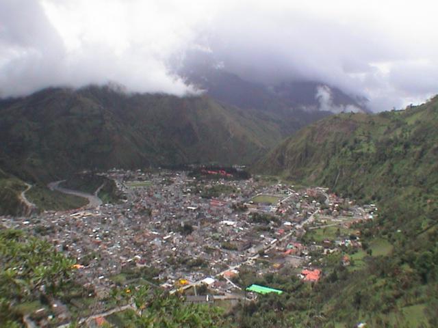 |
Figure 23. Oblique view looking at the town of Baños, 8 km N of Tungurahua's summit on the Pastaza River, June 2003. Copyrighted photo used with permission of Tim Travis. |
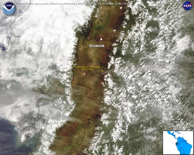 |
Figure 24. Satellite image showing ash plume from Tungurahua on 14 January 2004 (at 1530 UTC). The image came from the Moderate Resolution Imaging Spectroradiometer (MODIS), an instrument aboard the Terra satellite. Photo courtesy NOAA/NASA. |
Geological Summary. Tungurahua, a steep-sided andesitic-dacitic stratovolcano that towers more than 3 km above its northern base, is one of Ecuador's most active volcanoes. Three major edifices have been sequentially constructed since the mid-Pleistocene over a basement of metamorphic rocks. Tungurahua II was built within the past 14,000 years following the collapse of the initial edifice. Tungurahua II collapsed about 3,000 years ago and produced a large debris-avalanche deposit to the west. The modern glacier-capped stratovolcano (Tungurahua III) was constructed within the landslide scarp. Historical eruptions have all originated from the summit crater, accompanied by strong explosions and sometimes by pyroclastic flows and lava flows that reached populated areas at the volcano's base. Prior to a long-term eruption beginning in 1999 that caused the temporary evacuation of the city of Baños at the foot of the volcano, the last major eruption had occurred from 1916 to 1918, although minor activity continued until 1925.
Information Contacts: Geophysical Institute (IG), Escuela Politécnica Nacional, Apartado 17-01-2759, Quito, Ecuador (URL: http://www.igepn.edu.ec/); Washington Volcanic Ash Advisory Center (VAAC), Satellite Analysis Branch (SAB), NOAA/NESDIS E/SP23, NOAA Science Center Room 401, 5200 Auth Road, Camp Springs, MD 20746, USA (URL: http://www.ospo.noaa.gov/Products/atmosphere/vaac/); Tim Travis [contact information removed by request] (URL: http://www.DownTheRoad.org/).